OSINT from Satellite images

SRao

New Member
Joined
Jan 22, 2020
Messages
88
Likes
96
Country flag
2004 : you can see the Chinese black topped road and big circle to turn a round
View attachment 49197

2019: Same road. Black topped with circle. No change
View attachment 49196


As seen India doesnt have a road till this location. So we are on foot.

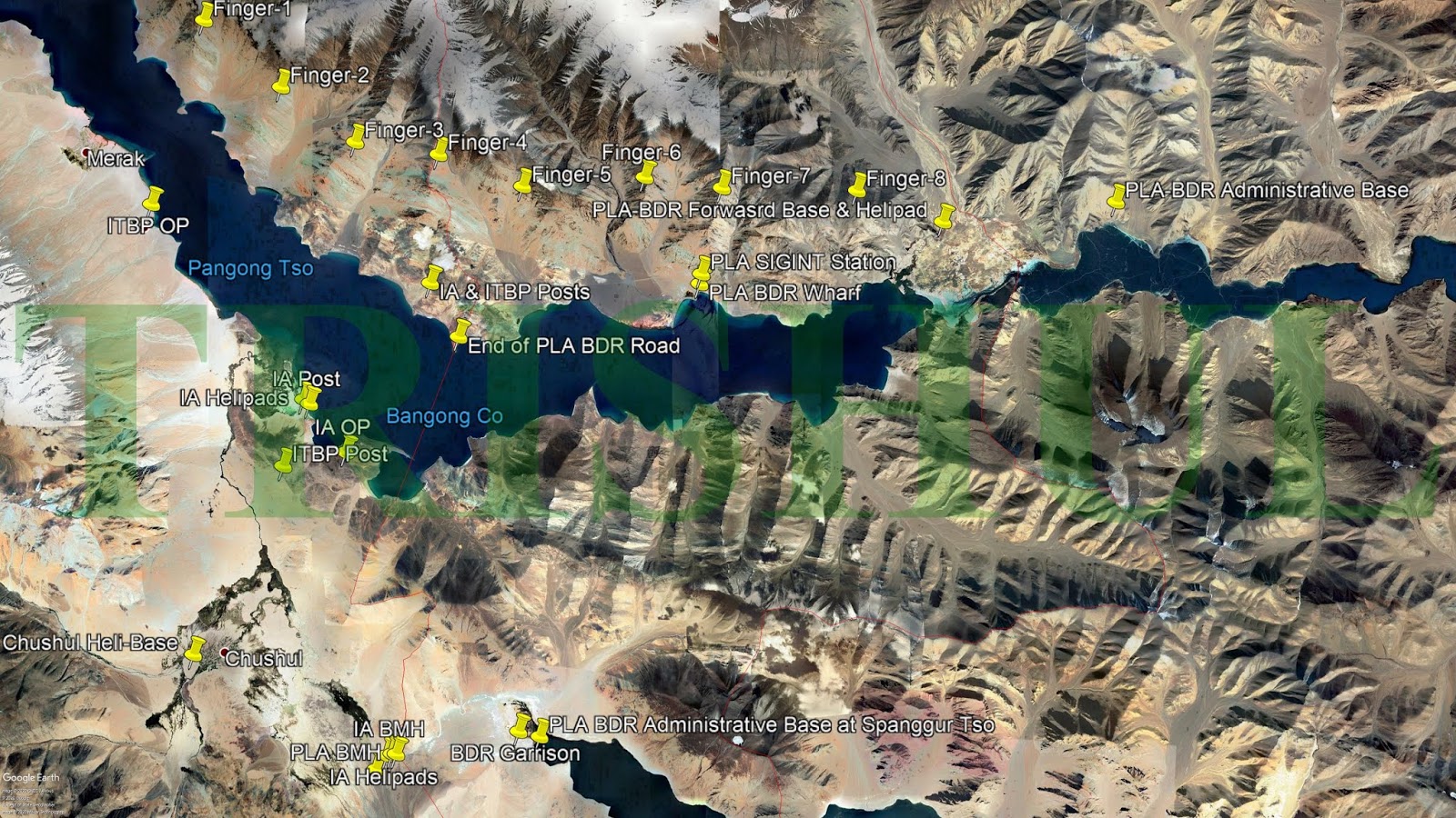
Now theres an issue what "finger" is this.

Most called it finger 4 on twitter and other forums


2) Iyer and Destresfa calls it finger 4
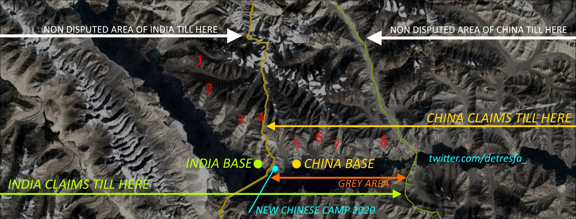
Doesn't matter finger 4 or 5. In the above picture, India has permanent presence till just before finger 4 ("India Base"), and China apparently has built permanent roads right under the nose of this India Base -a) without India knowing about this dangerous activity, or b) accepting that China has now occupied areas upto Finger 4, and India can do nothing about it.

If China has built blacktopped roads in finger 4, I would imagine they would have built roads all the way from finger 8 to finger 4! In effect, all these areas have been ceded by India to China all these years. China would definitely have fortified all these areas, and will not allow even a crow to enter these very sensitive areas, let alone IA patrols!

Under this scenario, to say IA is sending patrols all the way upto finger 8 seems incredulous- they are crossing over the chinese areas/roads in finger 4? Under the nose of chinese?

Chinese behavior in SCS is so drastically different- they will chase away/sink any boats that they think are in their area of control, rapidly build artificial islands/airstrips to tighten their grip. But here they are just lazy and lax?

No, something doesn't add up.
 

Tanmay

New Member
Joined
Dec 6, 2017
Messages
1,220
Likes
2,734
Country flag
Doesn't matter finger 4 or 5. In the above picture, India has permanent presence till just before finger 4 ("India Base"), and China apparently has built permanent roads right under the nose of this India Base -a) without India knowing about this dangerous activity, or b) accepting that China has now occupied areas upto Finger 4, and India can do nothing about it.

If China has built blacktopped roads in finger 4, I would imagine they would have built roads all the way from finger 8 to finger 4! In effect, all these areas have been ceded by India to China all these years. China would definitely have fortified all these areas, and will not allow even a crow to enter these very sensitive areas, let alone IA patrols!

Under this scenario, to say IA is sending patrols all the way upto finger 8 seems incredulous- they are crossing over the chinese areas/roads in finger 4? Under the nose of chinese?

Chinese behavior in SCS is so drastically different- they will chase away/sink any boats that they think are in their area of control, rapidly build artificial islands/airstrips to tighten their grip. But here they are just lazy and lax?

No, something doesn't add up.
Yes. Thats exactly my question to Lt.Gen Panag and Shooklaw.
How do we exactly patrol till finger 8 or even beyond finger 4.
The Chinese have a base at finger 6/7 itself. Near the Sirijap ground since 2004 or before
 

SRao

New Member
Joined
Jan 22, 2020
Messages
88
Likes
96
Country flag
Yes. Thats exactly my question to Lt.Gen Panag and Shooklaw.
How do we exactly patrol till finger 8 or even beyond finger 4.
The Chinese have a base at finger 6/7 itself. Near the Sirijap ground since 2004 or before
But you do see videos where Indian/Chinese soldiers are face-to-face. How is that possible if China is permanently present on the east side of finger 4 and india on the west? Where did the scuffle happen? To the west of F4 inside India? If so, India was sleeping. Was it to the east of, or in F4? Then PLA was sleeping- which I think is not possible given they are constantly trying to move westward and occupy land, inch-by-inch. Their strategy of occupying land by a thousand cuts, cannot be to occupy land, build permanent roads, and then retreat, allowing the enemy to freely patrol there!

I dont think Finger4 or other areas are permanently occupied by chinese- blacktop roads not withstanding. These are still areas that are grey zone, and so either parties were free to send in patrols. This time around the chinese have moved in men and equipment to F4, to rectify their lapse ( baffling to build roads and not have permanent presence). And this is causing India to wake up to the new reality.
 

Tanmay

New Member
Joined
Dec 6, 2017
Messages
1,220
Likes
2,734
Country flag

@DFIlite the western side of finger 4 i.e. facing Indian post seems to be very steep without any dirt track in GE images. How did their vehicles travel to our side. The area seems be be a vertical fall withoutmotorable ground.

1.PNG


So how did they manage to reach the plain area?

2.PNG
 

Tanmay

New Member
Joined
Dec 6, 2017
Messages
1,220
Likes
2,734
Country flag

Chinis have good landscaping. Maintain clean designs of facilities. Looks very TFTA.
Indian bases on other hand are a hazy distribution of buildings. Just layman fanboy stuff.


Tanmay

New Member
Joined
Dec 6, 2017
Messages
1,220
Likes
2,734
Country flag

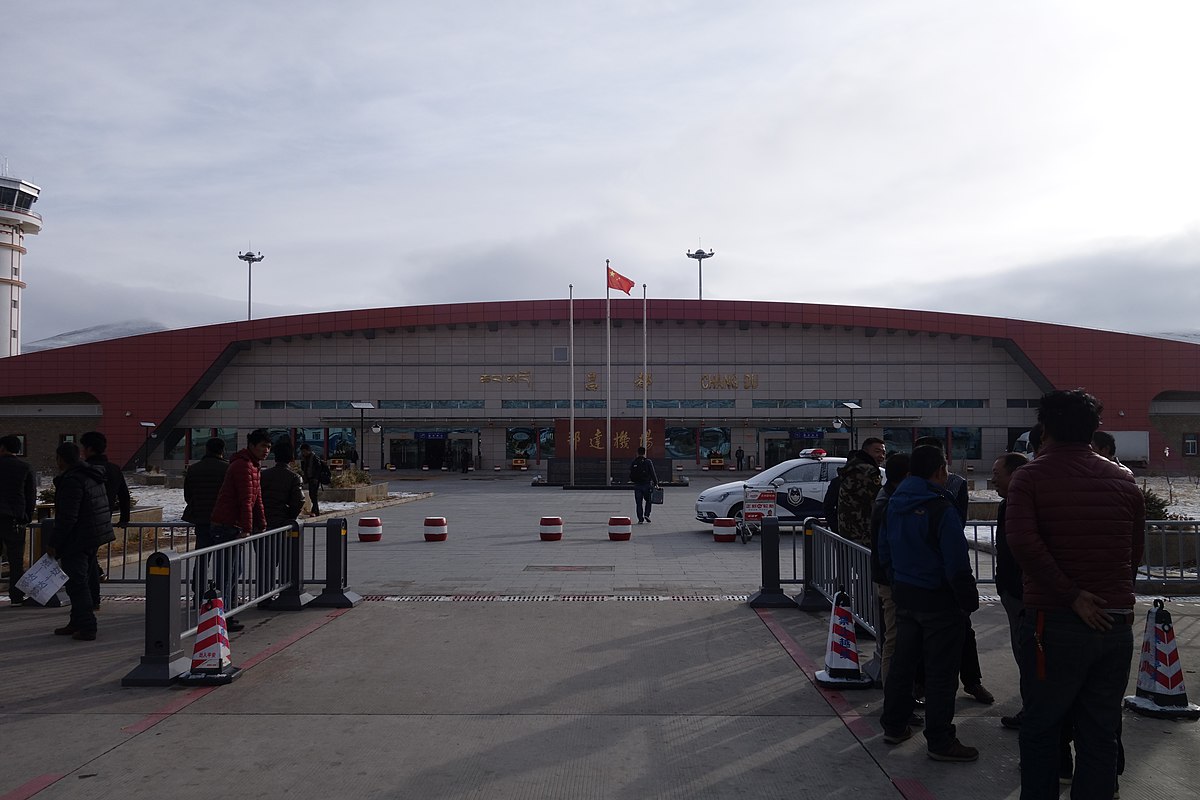
Also called Bangda airport. 180 kms away from Arunachal Pradesh.

04.PNG


A second parallel runway has been constructed after 2015. It has 2 parallel runways and a taxiway,
Runway length > 5.5 kms

01.PNG


After 2015 as you can see in follwing two images sports facilities have been constructed. Usual feature of most Chinese military bases. More living quarteres also built

02.PNG
03.PNG


Large parts of nearby land are not visible. This seems like they have asked google to block some imagery (weird guess)

30°41'12.15"N 96°53'4.54"E - Zoom full and scroll around. you will notice around this coodrinate.

Wild guess- It looks like parts along a river are being blocked from viewing.

https://en.wikipedia.org/wiki/Salween_River One of the river in th region from google maps
 

BeEverVectorMan

Tihar Jail
Banned
Joined
Jun 8, 2020
Messages
341
Likes
961
Country flag
Good work fellas, inspite having restricted 2d mapping you all are getting each area scanned and discussed

Thanks for such work
 

Tanmay

New Member
Joined
Dec 6, 2017
Messages
1,220
Likes
2,734
Country flag
This is Galwan Valley Region.

Big river is Shyok.

The SSN Road (aka D-S-DBO road) marked in black, passes by the Shyok riverbank. ITBP/IA camps are present on that road since 2011 and enlarged post 2015 as per satellite images.

Galwan is the smaller river.
Red line is LoAC (Indian perception it seems)

Do note the plateau like region marked in Pink Circle.
01.PNG


16th June 2020 imagery


Zooming to the pink circle. Its a somewhat flatter portion of hill. Makes it very distinct. So easy to identify in images.

02.PNG


03.PNG


Image below is at 34°45'10.18"N 78°14'18.69"E. The Pink Circle seems to be a flat portion of a hill as seen below.


So above buildup is on Chinese side

Image below is at 34°45'35.00"N 78°13'11.00"E.

Again on Chinese side.

Processed images by @DFIlite

So all in all, a large buildup by Chinese
 

Tanmay

New Member
Joined
Dec 6, 2017
Messages
1,220
Likes
2,734
Country flag
2004 : you can see the Chinese black topped road and big circle to turn a round
View attachment 49197

2019: Same road. Black topped with circle. No change
View attachment 49196


As seen India doesnt have a road till this location. So we are on foot.

Now theres an issue what "finger" is this.

Most called it finger 4 on twitter and other forums

1) Trishul calls it finger 4 http://trishul-trident.blogspot.com/


2) Iyer and Destresfa calls it finger 4


butttttttt

Today Lt.Gen Panag called it as finger 5

View attachment 49198


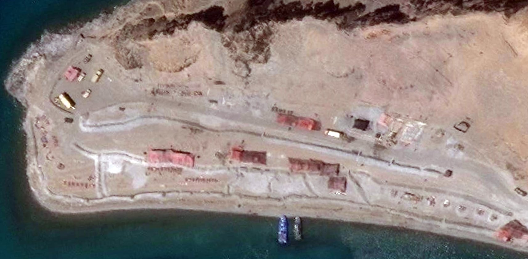
New images of what looks like Finger 4 to me. This is insane, Chinis have intruded a lot. We have definitely lost access to stuff beyond finger 4


Tanmay

New Member
Joined
Dec 6, 2017
Messages
1,220
Likes
2,734
Country flag
I am also in . I used to have terraserver account but now they shut shop

@Tanmay where did you got these latest images of finger 4 from ?
Sirji,
All latest images are from different twitter accounts which I mention in posts.

Those twitter accounts are not mine.
example: The image i post is address linked to the twiter account too. Just reverse google search

Occasionaly i do use planet labs. But the free stuff aint good resolution.
 

Concard

New Member
Joined
Jun 18, 2020
Messages
1,282
Likes
9,726
Country flag
Hello Guys my first on DFI,

Do you guys have any information about what it would like in Ladakh starting September where most Chinese bases are located? I have a feeling whatever Modi has planned is going to happen in Winter. Land invasion would be impossible through Ladakh I believe. I hope this is not off topic. It would be interesting to hear from you about the conditions in Winter concerning our border with China/Tibet. As someone from RSS I have a strong feeling Modi will not simply let this go.
 

IndianHawk

New Member
Joined
Sep 24, 2016
Messages
9,058
Likes
37,675
Country flag

Chinis have good landscaping. Maintain clean designs of facilities. Looks very TFTA.
Indian bases on other hand are a hazy distribution of buildings. Just layman fanboy stuff.


Indian bases are build upon real war experiences. Chinese neat buildings shows that they haven't fought a war in decades.
 

ladder

New Member
Joined
Mar 28, 2013
Messages
7,258
Likes
12,233
Country flag
Sirji,
All latest images are from different twitter accounts which I mention in posts.

Those twitter accounts are not mine.
example: The image i post is address linked to the twiter account too. Just reverse google search

Occasionaly i do use planet labs. But the free stuff aint good resolution.
With the image of Chinese development at finger finger 4/5. Why don't you visit again the image leaked by Chini of 5 IA/ITBP on ground with limbs tied. Report back if you find any matching.
 

Tanmay

New Member
Joined
Dec 6, 2017
Messages
1,220
Likes
2,734
Country flag
Indian bases are build upon real war experiences. Chinese neat buildings shows that they haven't fought a war in decades.
Well, I guess its Chinese trying to imitate American way of housing/infrastucture blocks and symmetrical architecture. example : Parallel roads, Rectuangular blocks in which houses are built. + large central building
Basically showing imposing images.

We on other hand go with stuff spread here and there according to natural barriers and ease and land acquisition issues
 

Tanmay

New Member
Joined
Dec 6, 2017
Messages
1,220
Likes
2,734
Country flag
With the image of Chinese development at finger finger 4/5. Why don't you visit again the image leaked by Chini of 5 IA/ITBP on ground with limbs tied. Report back if you find any matching.


I wont post the image of our troops restrained.


But to me it seems like Finger 4. Eastern side.

8.PNG

The photo of our troops restrained has a blue boat which is on shore+water. So the boat could come upto the land easily.

See the first photo. Boats are on shoreline. The land on eastern side of finger 4 is beach like. Its on same level as water. Troops were restrained while probaby trying to stop this activity it seems.

On western side (facing us) its a cliff.

Go to Google earth and check. The elevation of the land and water is same.(+-5 feet)
 
Thread starter Similar threads Forum Replies Date
DFIlite DFIlite twitter OSINT post OSINT 22
Haldilal OSINT Images Contribution Members Corner 74
Haldilal DFI OSINT Images Contribution. OSINT 8
H OSINT compilation thread Knowledge Repository 54
Similar threads


Articles

Top