OSINT from Satellite images

Tanmay

Senior Member
Joined
Dec 6, 2017
Messages
1,220
Likes
2,734
Country flag
27°43'10.19"N 68°47'58.37"E

PAF Sukkur


Looks like a flat land. Nothing interesting.
View attachment 36101


Drag the slider to 2016-17. This looks like an underground hardened building. Possibly a PAF command and control centre just like our IACCS. The 3 longish tubes are probably entry points or ventilation shafts. IAF will need some serious firepower to knock these off.

There should exist more such new hardened infra around other bases.

View attachment 36103

View attachment 36102

If anyone can find other such facilities in Pakistan, Please tag me when you post
 

Tanmay

Senior Member
Joined
Dec 6, 2017
Messages
1,220
Likes
2,734
Country flag
27°43'10.19"N 68°47'58.37"E

PAF Sukkur


Looks like a flat land. Nothing interesting.
View attachment 36101


Drag the slider to 2016-17. This looks like an underground hardened building. Possibly a PAF command and control centre just like our IACCS. The 3 longish tubes are probably entry points or ventilation shafts. IAF will need some serious firepower to knock these off.

There should exist more such new hardened infra around other bases.

View attachment 36103

View attachment 36102

He picked it up in September 2019, 2 months after I first posted on DFI. Some more insight as follow on


<blockquote class="twitter-tweet"><p lang="en" dir="ltr">Good work. It&#39;s about 8-9 stories deep underground. I wanted to ask, why they went in for water from canal, if this is nuke proof shelter. If nuke is hit. Water will be contaminated. Also powerline nearby. Coming from across the canal. <a href="https://t.co/LihxenO1FK">pic.twitter.com/LihxenO1FK</a></p>&mdash; Anup Sayare (@sayareakd) <a href="">September 27, 2019</a></blockquote> <script async src="https://platform.twitter.com/widgets.js" charset="utf-8"></script>
 

Tanmay

Senior Member
Joined
Dec 6, 2017
Messages
1,220
Likes
2,734
Country flag
I will just post what he found later

Multan Airbase Command and Control Centre

30°11'32.48"N 71°24'55.27"E


Funnily this structure dates back to 2013. India began constructing similar IACCS centres much later and many of these are still under contruction in India. Easy to find those if you read news.
 

Tanmay

Senior Member
Joined
Dec 6, 2017
Messages
1,220
Likes
2,734
Country flag
Dinjan Airfield, Assam

Its an old (WW2 era perhap)airfield, which now probably is only being used by Helicopters. Its primary use is as an EW site.

However recent Satellite Images show thats the runway is being relaid.

Previous : Runway in bad condition. Helo Landing sites visible as dark patches

10.PNG


Now:

11.PNG


Its situated right next to AFS Chabua.. (AFS Dinjan showed as red marker in pic)
12.PNG


P.S.: India should atleast put some pressure on Google to show Arunachal as part of India. Google shows it as disputed, hence border in red line.
Atleast in India , google should be forced to do it, if not worldwide
 

Tanmay

Senior Member
Joined
Dec 6, 2017
Messages
1,220
Likes
2,734
Country flag
Extreme slow progress of facilities for Akash SAM missile can be seen here for a north eastern airbase

2017 : work begins

15.PNG


2018 : some land clearance
16.PNG


2019: Ramp in construction

17.PNG


2020: Ramp still under construction. 4 rectangular pads seen

18.PNG


Ramp is used to station the Rajendra 2D Radar. 4 rectangle pads for parking 4 Akash SAM launchers..

Each airbasee has 2 such Ramps and 8 such pads for one Akash squadron
 

Tanmay

Senior Member
Joined
Dec 6, 2017
Messages
1,220
Likes
2,734
Country flag
I have a few doubts

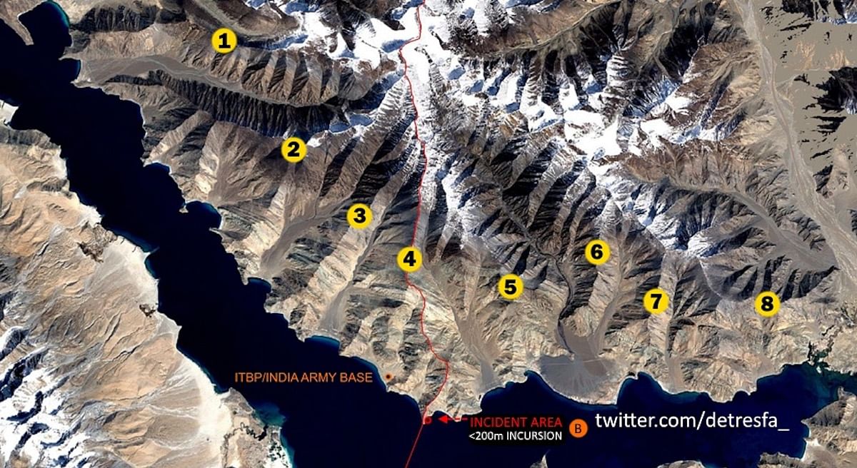
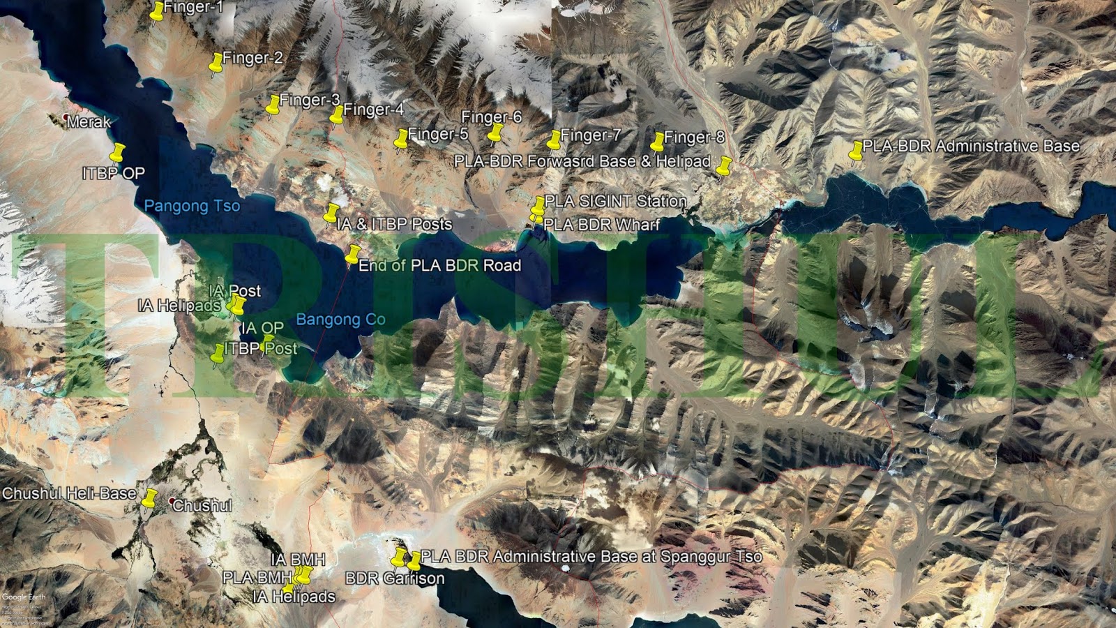
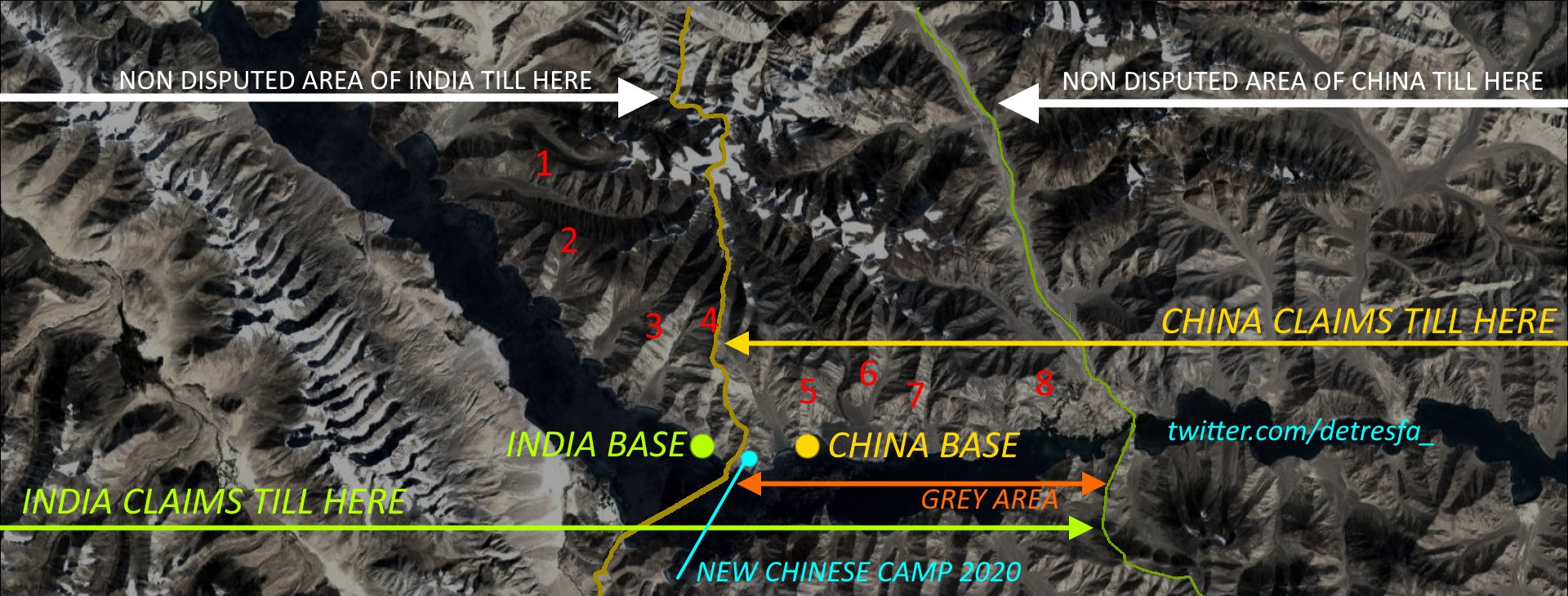
1) As per GE the chinese road till finger 4 has been present since even before 2004 (easrliest sat imagery).
So nothing new about road construction there. It was always a black topped road since atleast 2 decades


2) Indian black topped road ends at finger 3. An ITBP post is at the end of the road.
And the terrain between finngers 3 and 4 doesnt seem to even have a dirt track. So Indian vehicles cannot reach finger 4. While Chinese can send heavy armored 4x4 since 2 decades
 
Last edited:

Tanmay

Senior Member
Joined
Dec 6, 2017
Messages
1,220
Likes
2,734
Country flag

Cross posting from BR.

As evident from GE imagery and this video our own road was completed by 2013-14

Road from Phobrang (just a bit north of where the Pangong lake starts on our land)
 

SRao

Regular Member
Joined
Jan 22, 2020
Messages
88
Likes
96
Country flag
Dinjan Airfield, Assam

Its an old (WW2 era perhap)airfield, which now probably is only being used by Helicopters. Its primary use is as an EW site.

However recent Satellite Images show thats the runway is being relaid.

Previous : Runway in bad condition. Helo Landing sites visible as dark patches

View attachment 48087


Now:

View attachment 48086


Its situated right next to AFS Chabua.. (AFS Dinjan showed as red marker in pic)
View attachment 48088

P.S.: India should atleast put some pressure on Google to show Arunachal as part of India. Google shows it as disputed, hence border in red line.
Atleast in India , google should be forced to do it, if not worldwide
Pichai, an Indian by birth, and having used Indian resources like the IITs, is now licking Chinese boots. Dont expect much from such mercenaries who will sell their country for a few bucks. He will only toe the Chinese line.
 

Tanmay

Senior Member
Joined
Dec 6, 2017
Messages
1,220
Likes
2,734
Country flag
Looking at Galwan Valley incident.

The yellow line aka Road to SSN joins Durbuk-Shyok-Daulat Beg Oldie
So this is the D-S-DBO road
SSN means Sub Sector North

gal.PNG
 

Tanmay

Senior Member
Joined
Dec 6, 2017
Messages
1,220
Likes
2,734
Country flag
I have a few doubts

1) As per GE the chinese road till finger 4 has been present since even before 2004 (easrliest sat imagery).
So nothing new about road construction there. It was always a black topped road since atleast 2 decades


2) Indian black topped road ends at finger 3. An ITBP post is at the end of the road.
And the terrain between finngers 3 and 4 doesnt seem to even have a dirt track. So Indian vehicles cannot reach finger 4. While Chinese can send heavy armored 4x4 since 2 decades

As I had already pointed out on 31st May, the Chinese already had a blacktopped road with turnaround till finger 4 since 2004 (or even 1999, as they probably built it while we were busy with Kargil war)

So even I didnt understand what Panag and Shukla were saying. To say that we patrolled till fingerr 8 when our road ends at finger 3 and chinese road exists till finger 4, means we were at severe disadvantage since past 20 years. How did we patrol beyond finger 4? On foot. But chinese could easily send heavy vehicles to prevent patrol from going ahead. What Panag did during his tenure to prevent or destroy Chinese road needs to be clear.


SRao

Regular Member
Joined
Jan 22, 2020
Messages
88
Likes
96
Country flag
As I had already pointed out on 31st May, the Chinese already had a blacktopped road with turnaround till finger 4 since 2004 (or even 1999, as they probably built it while we were busy with Kargil war)

So even I didnt understand what Panag and Shukla were saying. To say that we patrolled till fingerr 8 when our road ends at finger 3 and chinese road exists till finger 4, means we were at severe disadvantage since past 20 years. How did we patrol beyond finger 4? On foot. But chinese could easily send heavy vehicles to prevent patrol from going ahead. What Panag did during his tenure to prevent or destroy Chinese road needs to be clear.


Something doesn't square up.

If area till Finger 4 was under chinese control - if they have built up blacktopped roads till this area means, they must have brought in heavy roadmaking equipment, men, and other resources, over time, and now they must be having heavy presence there. If PLA is ruthless everywhere else, with everyone else, to say that they were kind enough to let IA patrols "INSIDE" areas they control is pure BS! And I dont believe that they would not have had permanent presence till finger 4 if they controlled it. This being an area where every advantage will be held on to fiercely, chinese being so lax is unbelievable.
 

Tanmay

Senior Member
Joined
Dec 6, 2017
Messages
1,220
Likes
2,734
Country flag
Something doesn't square up.

If area till Finger 4 was under chinese control - if they have built up blacktopped roads till this area means, they must have brought in heavy roadmaking equipment, men, and other resources, over time, and now they must be having heavy presence there. If PLA is ruthless everywhere else, with everyone else, to say that they were kind enough to let IA patrols "INSIDE" areas they control is pure BS! And I dont believe that they would not have had permanent presence till finger 4 if they controlled it. This being an area where every advantage will be held on to fiercely, chinese being so lax is unbelievable.
2004 : you can see the Chinese black topped road and big circle to turn a round
fin1.PNG


2019: Same road. Black topped with circle. No change
fin2.PNG


As seen India doesnt have a road till this location. So we are on foot.

Now theres an issue what "finger" is this.

Most called it finger 4 on twitter and other forums

1) Trishul calls it finger 4 http://trishul-trident.blogspot.com/


2) Iyer and Destresfa calls it finger 4


butttttttt

Today Lt.Gen Panag called it as finger 5

fin3.jpg


Thread starter Similar threads Forum Replies Date
DFIlite DFIlite twitter OSINT post OSINT 22
Haldilal OSINT Images Contribution Members Corner 69
Haldilal DFI OSINT Images Contribution. OSINT 8
H OSINT compilation thread Knowledge Repository 54
Similar threads


Global Defence

New threads

Articles

Top