OSINT from Satellite images
- Thread starter sayareakd
- Start date
More options
Who Replied?- Joined
- Jun 19, 2020
- Messages
- 2,735
- Likes
- 5,773
No probably Airbus.Is That MH370 ???
Pink road = DSDBO
Orange road = a new blacktopped road as an alternate road from TACHQ to DBO. Probably to provide depth. The road is along Chip Chap river which enters India at DBO
Maroon Road = New road which is NOT blacktopped. Probably mostly a patrol route/ mule track. But seems to be BMP/Tank road as a wild guess from me
Bottommost Orange Road = Alternate Sasoma - Saser La - Murgo Road incase Galwan is interdicted
Blue river = Shyok
Light Blue / Cyan River = Chip Chap (enters Indian side at DBO)
A few samples of road condition
Orange road = a new blacktopped road as an alternate road from TACHQ to DBO. Probably to provide depth. The road is along Chip Chap river which enters India at DBO
Maroon Road = New road which is NOT blacktopped. Probably mostly a patrol route/ mule track. But seems to be BMP/Tank road as a wild guess from me
We zoom to the point where Shyok river (Blue) meets Chip Chap river (Cyan)
See the below 2 images of the confulence (of Shyok and Chip Chap steam)
The big grey land is Shyok river. Smaller stream is ChipChap
No road outline in 2019
A faint white outline of road is visible in August 2020 (poor quality planetlab image)
continued below
We now zoom into the Sasoma- Saser La - Murgo road (Orange Road)
A small short Brown offshoot road can be seen

You can makethe road outline and a bridge. The bridge seems to be a foot bridge (NOT vehicle bridge)

Probably we are making a parallel road from Murgo to DSDBO via Shyok River.
The road will be along Shyok river from the foot bridge(south end) to the confluence point(north end)
This road will then join the top orange road.
So the bottom orange road will be connected to the top orange road via Shyok river
People with access to better satellite imagery may confirm.
Coordinates of foot bridge : 35° 4'45.27"N 77°46'17.72"E
Coordinates of confluence point : 35°16'30.68"N 77°44'34.60"E
A small short Brown offshoot road can be seen
You can makethe road outline and a bridge. The bridge seems to be a foot bridge (NOT vehicle bridge)
Probably we are making a parallel road from Murgo to DSDBO via Shyok River.
The road will be along Shyok river from the foot bridge(south end) to the confluence point(north end)
This road will then join the top orange road.
So the bottom orange road will be connected to the top orange road via Shyok river
People with access to better satellite imagery may confirm.
Coordinates of foot bridge : 35° 4'45.27"N 77°46'17.72"E
Coordinates of confluence point : 35°16'30.68"N 77°44'34.60"E
Did the Chinese leave back their tents/housing intact after vacating Doklam?
The place is littered with housing and possible equipment and possible vehicles
27°17'44.73"N 88°54'52.17"E

2018 : No Blue structure

2019 : Blue structure ( 27°18'36.53"N 88°57'37.66"E) comes up. Road seems better

2018: status (wasnt august 2017 the end of the standoff? I see a dozen trucks parked on top left)

2019 : New things which look like vehicle visible now near housing. And other changes visible

There doesnt seem to be any road from Bhutanese side. So they cant bring trucks
The Chinese have left structures intact. Both their roads still have access. No roadblocs or destruction of road.
The place is littered with housing and possible equipment and possible vehicles
27°17'44.73"N 88°54'52.17"E
2018 : No Blue structure
2019 : Blue structure ( 27°18'36.53"N 88°57'37.66"E) comes up. Road seems better
2018: status (wasnt august 2017 the end of the standoff? I see a dozen trucks parked on top left)
2019 : New things which look like vehicle visible now near housing. And other changes visible
There doesnt seem to be any road from Bhutanese side. So they cant bring trucks
The Chinese have left structures intact. Both their roads still have access. No roadblocs or destruction of road.
the photo in the post here DOES NOT have any LAC shown, as you can see from the above post that the LAC is 30km away from this part of Shyok riverWe now zoom into the Sasoma- Saser La - Murgo road (Orange Road)
A small short Brown offshoot road can be seen
View attachment 55348
You can makethe road outline and a bridge. The bridge seems to be a foot bridge (NOT vehicle bridge)
View attachment 55349
Probably we are making a parallel road from Murgo to DSDBO via Shyok River.
The road will be along Shyok river from the foot bridge(south end) to the confluence point(north end)
This road will then join the top orange road.
So the bottom orange road will be connected to the top orange road via Shyok river
People with access to better satellite imagery may confirm.
Coordinates of foot bridge : 35° 4'45.27"N 77°46'17.72"E
Coordinates of confluence point : 35°16'30.68"N 77°44'34.60"E
See the yellow lie between the area I described and the LAC. 30 km approx
@sayareakd @DFIlite Does this look like a Command and Control centre ? Or a normal building
32°35'5.11"N 71°33'7.82"E
Pakistan- Near Mianwali airbase


32°35'5.11"N 71°33'7.82"E
Pakistan- Near Mianwali airbase
Pakis made a new airbase and built HAS for it. While Phalodi and north eastern airbases remain without HAS 
Not to mention Sukhois dont fit in existing HAS
wonder if IAF would have rejected Sukhois because they dont fit in HAS, like Arjuns dont fit on older bridges and logistics
Not to mention Sukhois dont fit in existing HAS
wonder if IAF would have rejected Sukhois because they dont fit in HAS, like Arjuns dont fit on older bridges and logistics
Well a leak from our side is of great importance for our understanding.
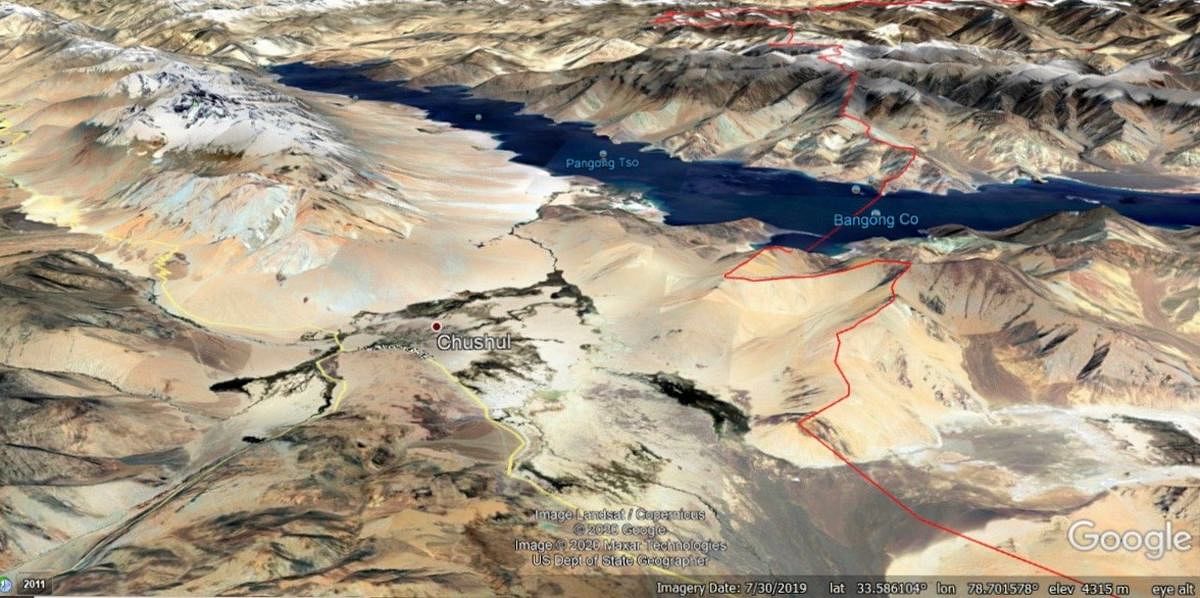
1) Google Earth and Google Maps dont depict LAC. At most they show claim lines
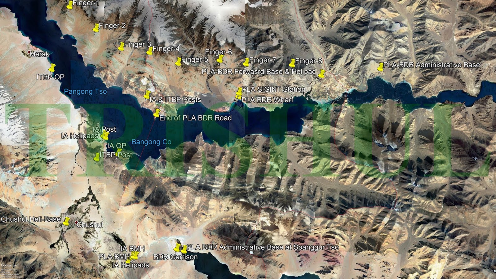
2) Detresfa/Iyerr, Lt.Gen Panag, Trishul --- all showed wrong interpretation of Finger areas and LAC
Most interesting stuff. If red is Chinese Claim line, How is the "Chinese road turning point " outside the Chinese claim line. Also our own map has LAC marked differently as PINK line(approx). So LAC itself is outside chinese claim line(Chinese claim line as per google earth) ????

P.S. My marking of Helmet top and Black Top may be incorrect/approximate
So this numbering of fingers by detresfa and Iyer is surely wrong
Even Lt.Gen Panag seems wrong wrt finger 4. But he is correct about the fact that finger 8 is LAC and all fingers to the west of Sirijap
Even Trishul is wrong

1) Google Earth and Google Maps dont depict LAC. At most they show claim lines
2) Detresfa/Iyerr, Lt.Gen Panag, Trishul --- all showed wrong interpretation of Finger areas and LAC
Most interesting stuff. If red is Chinese Claim line, How is the "Chinese road turning point " outside the Chinese claim line. Also our own map has LAC marked differently as PINK line(approx). So LAC itself is outside chinese claim line(Chinese claim line as per google earth) ????
P.S. My marking of Helmet top and Black Top may be incorrect/approximate
So this numbering of fingers by detresfa and Iyer is surely wrong
Even Lt.Gen Panag seems wrong wrt finger 4. But he is correct about the fact that finger 8 is LAC and all fingers to the west of Sirijap
Even Trishul is wrong

Last edited by a moderator:
scatterStorm
New Member
- Joined
- May 28, 2016
- Messages
- 2,243
- Likes
- 5,360
Google maps are local maps and each country can ask google to show there representation of maps. You can also say that tech giants can shape opinion too.Well a leak from our side is of great importance for our understanding.
1) Google Earth and Google Maps dont depict LAC. At most they show claim lines
2) Detresfa/Iyerr, Lt.Gen Panag, Trishul --- all showed wrong interpretation of Finger areas and LAC
Most interesting stuff. If red is Chinese Claim line, How is the "Chinese road turning point " outside the Chinese claim line. Also our own map has LAC marked differently as PINK line(approx). So LAC itself is outside chinese claim line(Chinese claim line as per google earth) ????
View attachment 58207
P.S. My marking of Helmet top and Black Top may be incorrect/approximate
So this numbering of fingers by detresfa and Iyer is surely wrong
Even Lt.Gen Panag seems wrong wrt finger 4. But he is correct about the fact that finger 8 is LAC and all fingers to the west of Sirijap
Even Trishul is wrong

Take the case of Libya and Venezuela. These tech giants are known to work with CIA, FBI to push there agenda. No wonder Chinese threw out google from there country.

Army now holding 30 dominating heights, earlier unoccupied, on southern bank of Pangong Tso
The heights include Rezang La and Reqin La, a series dominating Spanggur Gap covering Patrol Points 27 to 31, among others.
 theprint.in
According to government sources, the heights include the Rezang La and Reqin La, both dominating the Spanggur Gap and covering Patrol Points 27 to 31. They also include the dominating heights of Black Top, Hanan, Helmet, Gurung Hill, Gorkha Hill and Magar Hill among others.
PP 27 seems to be marked in above image
This is a weird find and could be a DFI exclusive OSINT if my finding is correct
@DFIlite @sayareakd @Yusuf
A possible new mountain tunnel missile facility for Pakistan
2004 : Construction begins

2010 : Road and tunnel begins. Yellow markers are possible tunnels


What seems like smaller roads leading to tunnels

Long Rectaungular halls like those are generally missile preparations halls.
A motor pool garrage like structure is visible

Locations:
Tunnel 1 : 32°34'53.33"N 72°18'22.86"E

Tunnel 2 : 32°34'54.05"N 72°18'18.51"E
Tunnel 3 : 32°34'52.02"N 72°18'4.80"E

Tunnel 4 : 32°35'10.46"N 72°18'25.39"E

Possibly more stuff could exist. But thats what i could find
@DFIlite @sayareakd @Yusuf
A possible new mountain tunnel missile facility for Pakistan
2004 : Construction begins
2010 : Road and tunnel begins. Yellow markers are possible tunnels
What seems like smaller roads leading to tunnels
Long Rectaungular halls like those are generally missile preparations halls.
A motor pool garrage like structure is visible
Locations:
Tunnel 1 : 32°34'53.33"N 72°18'22.86"E
Tunnel 2 : 32°34'54.05"N 72°18'18.51"E
Tunnel 3 : 32°34'52.02"N 72°18'4.80"E
Tunnel 4 : 32°35'10.46"N 72°18'25.39"E
Possibly more stuff could exist. But thats what i could find
Pakistani military base facing afghanistan with 2 deployed Artillery. Just around 10 km away from Pakistan-Afghanistan border
The base is pretty different from the usual rural landscape around it
Location : 34°51'49.29"N 71°31'13.75"E


The base is pretty different from the usual rural landscape around it
Location : 34°51'49.29"N 71°31'13.75"E
@sayareakd @DFIliteThis is a weird find and could be a DFI exclusive OSINT if my finding is correct
@DFIlite @sayareakd @Yusuf
A possible new mountain tunnel missile facility for Pakistan
2004 : Construction begins
View attachment 61063
2010 : Road and tunnel begins. Yellow markers are possible tunnels
View attachment 61064View attachment 61065
What seems like smaller roads leading to tunnels
View attachment 61066
Long Rectaungular halls like those are generally missile preparations halls.
A motor pool garrage like structure is visible
View attachment 61067
Locations:
Tunnel 1 : 32°34'53.33"N 72°18'22.86"E
View attachment 61068
Tunnel 2 : 32°34'54.05"N 72°18'18.51"E
Tunnel 3 : 32°34'52.02"N 72°18'4.80"E
View attachment 61069
Tunnel 4 : 32°35'10.46"N 72°18'25.39"E
View attachment 61070
Possibly more stuff could exist. But thats what i could find
Another possible jackpot and DFI exclusive
A second tunnel facility at different location near Islamabad under construction as of 2020
10 km away from Islamabad Airport
2004 Virgin mountain with no human activity
2005 : Construction begins with roads
2020 : Expansion of construction activity
Tunnel 1 : 33°28'3.90"N 72°46'50.55"E
Tunnel 2 : 33°27'44.08"N 72°46'8.25"E
Tunnel 3 : 33°27'26.02"N 72°46'35.19"E
So two possible Pakistani Nuclear Storage Tunnel facilities uncovered !!
| Thread starter | Similar threads | Forum | Replies | Date |
|---|---|---|---|---|
|
|
DFIlite twitter OSINT post | OSINT | 22 | |
|
|
OSINT Images Contribution | Members Corner | 74 | |
|
|
DFI OSINT Images Contribution. | OSINT | 8 | |
| H | OSINT compilation thread | Knowledge Repository | 54 |
Articles
-
India Strikes Back: Operation Snow Leopard - Part 1
- mist_consecutive
- Replies: 9
-
Aftermath Galwan : Who holds the fort ?
- mist_consecutive
- Replies: 33
-
The Terrible Cost of Presidential Racism(Nixon & Kissinger towards India).
- ezsasa
- Replies: 40
-
Modern BVR Air Combat - Part 2
- mist_consecutive
- Replies: 22
-
Civil & Military Bureaucracy and related discussions
- daya
- Replies: 32

