Brahmaputra diversion by China: How should India respond?

JAYRAM

2 STRIKE CORPS
Senior Member
Joined
Mar 8, 2011
Messages
3,282
Likes
316
Chinese engineers propose world's biggest hydro-electric project in Tibet

Mega-dam on Yarlung Tsangpo river would save 200m tonnes of CO2 but could spark conflict over downstream water supply

Jonathan Watts, Asia environment correspondent
guardian.co.uk, Monday 24 May 2010 16.00 BST


River on the roof of the world ... the Yarlung Tsangpo/Brahmaputra river. Photograph: Imaginechina


Chinese hydropower lobbyists are calling for construction of the world's biggest hydro-electric project on the upper reaches of the Brahmaputra river as part of a huge expansion of renewable power in the Himalayas.

Zhang Boting, the deputy general secretary of the China Society for Hydropower Engineering, told the Guardian that a massive dam on the great bend of the Yarlung Tsangpo - the Tibetan name for the river - would benefit the world, despite the likely concerns of downstream nations, India and Bangladesh, which access water and power from the river.

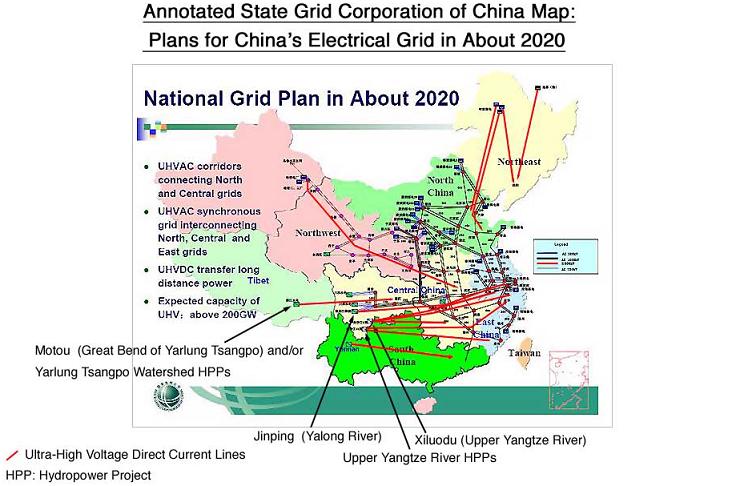
Zhang said research had been carried out on the project, but no plan has been drawn up. But documents on the website of a government agency suggest a 38 gigawatt hydropower plant is under consideration that would be more than half as big again as the Three Gorges dam, with a capacity nearly half as large as the UK's national grid.

"This dam could save 200m tonnes of carbon each year. We should not waste the opportunity of the biggest carbon emission reduction project. For the sake of the entire world, all the water resources than can be developed should be developed." That CO2 saving would be over a third of the UK's entire emissions.

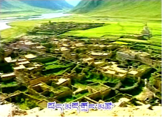
The mega-facility is among more than 28 dams on the river that are either planned, completed or under discussion by China, according to Tashi Tsering, a Tibetan scholar of environmental policy at the University of British Columbia.

Tsering publishes a map today of all of the projects that have been reported by Chinese newspapers and hydro-engineering websites.

From this, he concludes that the Tsangpo-Brahmaputra – until recently considered the last great undammed river in Tibet – will be the next focus of government efforts to increase the nation's power supply. One of them is a map of planned dams showing a 38-gigawatt hydro-plant at Motuo on the website of Hydro China, an influential government enterprise responsible for dam construction. A separate State Grid map of future transmission lines indicates the remote area will soon be connected to the rest of China's power supply. Hydro China and State Grid declined requests for clarification.

The government has not confirmed the existence of the scheme, but Tsering cites several newspaper reports of survey teams exploring the area and provides links to other online documents that indicate preparations for large-scale hydro-development of the area.

Given the huge expense, technical difficulties and political sensitivities of the scheme, it is far from certain of final approval by the government. But several Chinese hydroengineers see it as the ultimate goal in an accelerating race with India to develop water resources in one of the planet's last remote regions.

Tapping the power of the river as it bends and plunges from the Himalayan roof of the world down towards the Indian and Bangladeshi flood plains has long been a dream of the world's hydro-engineers.

Along with the Congo river at the Inga falls, this is considered one of the two greatest concentrations of river energy on earth, but it was long thought impossible to access because of the rugged, high-altitude terrain and the risk of water-related conflict with neighbouring countries.

But China has overcome many engineering obstacles with the construction of the railway to Tibet, and its growing energy demands are spurring exploration of ever more remote areas.

"Tibet's resources will be converted into economic advantage," Yan Zhiyong, the general manager of China Hydropower Engineering Consulting Group, told China Energy News earlier this year. "The major technical constraints on damming the Yarlung Tsampo have been overcome." He declined the Guardian's request for an interview, saying the subject was too sensitive.

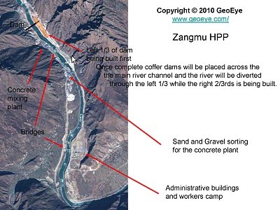
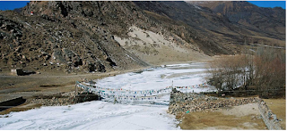
The exploitation of the Brahmaputra is already under way. China recently announced plans to build five dams further upstream, including a 500MW hydroplant at Zangmu, which is under construction by the power utility Huaneng.

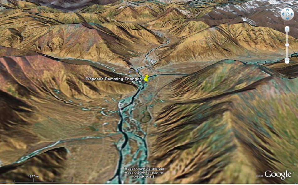
According to Tsering, the biggest of them will be a huge plant at the great bend – either at Metog, known as Motuo in Chinese, or at Daduqia. The former would involve the construction of a series of tunnels, pipes, reservoirs and turbines to exploit the spectacular 2,000-metre fall of the river as it curls down towards India.

Although there has been no official confirmation of plans for a dam, the discussion is far from secret. On a prominent Chinese science forum, Zhang said a dam on the great bend was the ultimate hope for water resource exploitation because it could generate energy equivalent to 100m tonnes of crude coal, or all the oil and gas in the South China sea.

He warned that a delay would allow India to tap these resources and prompt "major conflict" in a region where the two nations have sporadically clashed over disputed territory.

"We should build a hydropower plant in Motuo ... as soon as possible because it is a great policy to protect our territory from Indian invasion and to increase China's capacity for carbon reduction," he wrote last year

Any step forward is likely to be controversial. Tibetans consider Metog a sacred region, and environmental activists warn against building such a huge project in a seismically active and ecologically fragile area.

"A large dam on the Tibetan plateau would amount to a major, irreversible experiment with geo-engineering," said Peter Bosshard of International Rivers. "Blocking the Yarlung Tsangpo could devastate the fragile ecosystem of the Tibetan plateau, and would withhold the river's sediments from the fertile floodplains of Assam in north-east India, and Bangladesh."

China's construction of dams also raises the prospect of a race with India to develop hydropower along south Asia's most important river.

"India needs to be more aggressive in pushing ahead hydro projects (on the Brahmaputra)," Jairam Ramesh, the Indian environment minister, told the Guardian during a recent visit to Beijing. "That would put us in better negotiating position (with China).

To minimise the risk of water-related conflict, the two nations have agreed to share information about hydro-plans on the Tsangpo-Brahmaputra.

Indian media have raised concerns that Beijing may ultimately embark on a gigantic diversion scheme that would channel water away from India to the dry northern plains of China, but such fears are dismissed by Tsering, who says the dam at Metog would be for hydropower, not water diversion. "The laws of physics will not allow water diversion from the Great Bend."

Chinese engineers propose world's biggest hydro-electric project in Tibet | Environment | The Guardian
 

JAYRAM

2 STRIKE CORPS
Senior Member
Joined
Mar 8, 2011
Messages
3,282
Likes
316
A new era for Tibet's rivers
Jiang Yannan
He Haining
January 17, 2011

Construction of a massive dam on the Yarlung Zangbo marks a turning point for Tibet, write He Haining and Jiang Yannan. A development boom is coming.


The rushing waters of the Yarlung Zangbo, the last of China's great rivers to remain undammed, will soon be history. On November 12 last year, the builders of the Zangmu Hydropower Station announced the successful damming of the river – the first public announcement on a matter that, until now, has been kept under wraps.

The Zangmu hydroelectric power station is being built on the middle reaches of the Yarlung Zangbo (known as the Brahmaputra when it reaches India) between the counties of Sangri and Gyaca. Around 7.9 billion yuan (US$1.2 billion) is being invested in the project, located in a V-shaped valley 3,200 metres above sea level. At 510 megawatts, the plant is much smaller than China's 18,000-megawatt Three Gorges Dam, but still equivalent to the entire existing hydropower-generating capacity of Tibet.

The construction workers have now reached the centre of the river. The water is being diverted into sluiceways and rows of grouting machines and stone crushers are working at full pace, while trucks come and go. One worker said that the winter here is mild, so there'll be no need to stop work. Geologist Yang Yong said the activity represents the start of a new age: "Hydropower development on the Yarlung has begun, marking the start of a hydropower era for Tibet's rivers."

A series of hydropower stations is proposed for the Yarlung Zangbo. If they are all built, Zangmu will be the fourth in a row of five on the Sangri to Gyaca stretch of the river, between the Gyaca and Jiexu plants. There has been no official confirmation that the construction of these will go ahead. But Yan Zhiyong, general manager of China Hydropower Engineering Consulting, said in a recent media interview: "By about 2020 most of China's hydropower projects outside of Tibet will have been completed, and the industry's focus will shift to the Jinsha, Lancang, the upper reaches of the Nu River and the Yarlung."

Several well-known Chinese hydropower firms have already made their way into Tibet. The backer of the Zangmu project, the Tibet Generating Company, has already built a residential area on the open spaces alongside the river at Zangmu and a flourishing town is taking shape, with a supermarket better-stocked than those in the county's main town. The boss, from Zhejiang, moved here from the Xiaowan dam in Yunnan, south-west China, two months ago and is positive about the future: "There'll be loads of workers next year, business will be great."

The Zangmu dam is located in the southern Tibetan county of Gyaca, which has a population of around 17,000. "The economy here is going to be among the fastest-growing in Tibet," said businessman Li Hua, who has already invested in a three-star hotel here – a five-storey building that is now the tallest in the area.

Work on a highway to the administrative centre of Lhoka prefecture is to start in 2011, cutting travel time in half. "Hydropower development will very quickly spur mining, and there'll also be very rapid growth in road and railways. The Tibetan hinterland will see a new development boom," predicted Yang Yong.

Guan Zhihua is a researcher at the Chinese Academy of Sciences' Institute of Geographic Sciences and Natural Resources Research. In 1972 the academy established a survey team to study the Qinghai-Tibetan Plateau, and Guan – now in his seventies – was the head of the group charged with calculating the hydropower potential of the Yarlung Zangbo, China's highest river. As if describing a family heirloom, he said: "The river flows for 2,057 kilometres within China's borders, and its hydropower potential is second only to the Yangtze. It has more power-generating potential per unit of length than any other river in China."

Guan's was the first comprehensive and systematic study of the plateau – a four year field project carried out by more than 400 people across 50 different disciplines. But the study of the Yarlung Zangbo and its tributaries was only a part of the survey, and at the time nobody had any idea of the extent of the river's potential. The entire basin was found to have hydropower potential of 114 gigawatts – 79 of which was on the main river. And this potential was highly concentrated, with the possibility of a 38-gigawatt hydropower facility at the Great Bend in Medog county, equal in power to the Three Gorges Dam.

In 1980, a nationwide survey of hydropower resources was carried out and 12 possible dam locations identified on the Yarlung Zangbo. "This would have been the first hydropower plan for the Yarlung," recalled Guan.

In the 1980s, Tibet twice planned to dam the Yarlung Zangbo, but in neither case did the project get off the ground

Zhang Jinling, a 76-year old retiree from the Tibet Surveying Institute, recalled the first bid to build a dam here: "In the 1980s, Shigatse [a city in southern Tibet] wanted to build a hydropower station at Jiangdang and that would have been the first attempt to dam the river." But there were concerns: this part of the river carries a lot of silt and the project would have required swaths of land to be inundated and many people to be relocated – and the dam would only generate 50 megawatts of power. The plan was submitted to Beijing, but was not approved.

On another occasion, plans were drawn up to dam the river outside Lhasa. Zhang's team carried out preliminary surveys, drilling rock samples out of the mountainsides to acquire geological data. But a large reshuffle of officials in both 1981 and 1982 saw the team lose two-thirds of its manpower. Plans were shelved.

Those plans were spurred by a shortage of electricity in Tibet. Zhang recalled that the Tibetan government was seeking a quick way of providing power by any means – diesel-fired and geothermal power generation were also used.

During the 1980s, Lhasa, with 120,000 residents, only had 20 or 30 megawatts of power-generating capacity, mostly provided by several hydropower stations each providing a few megawatts. In winter there was no choice but to rotate power supplies to different areas of the city, with those cut off using kerosene for heating.

When Zhang retired in 1995, the electricity grid in eastern Tibet was just beginning to take shape, but it has remained isolated from the national grid. A connection between Tibet and Qinghai is due to be completed in 2012, which will relieve the electricity shortages Tibet suffers in winter and spring.

"It wouldn't have been possible to build a large dam on the Yarlung before the Qinghai-Tibet railway was completed – you need a rail line to move the building materials," said He Xiwu, who was head of the survey team's water-resources group at the time.

In 1994, work started on the Three Gorges Dam, but plans for the Yarlung Zangbo were kept quiet. The low-key approach was unusual given the river's huge potential. Even recently, a water-resources official with the Tibetan government stressed that developing hydropower in Tibet was mostly about self-sufficiency.

Since the early 1990s, Tibet has built a series of medium-sized hydropower stations, of about 10 megawatts each, such as the pumped-storage hydropower station at Yamdrok Lake and the dam at Zhikong. These are intended to relieve electricity shortages in the Lhasa area.

Although government work reports mention it every year, hydropower development on the Yarlung Zangbo was never made a priority. But in the final years of the 11th Five Year Plan, things changed. "The current proposal is an appropriate degree of industrialisation, with a process of capacity building, then focusing on priorities, and then overall development," said He Gang, research fellow at the Tibet Academy of Social Sciences' Institute of Economic Strategy. "The priorities most often proposed are mining and hydropower."

Behind the scenes, preparations for hydropower development on the Yarlung Zangbo have been constant. In a recent media interview, Zhi Xiaoqian, head of the Chengdu Surveying Institute, said that plans had been drawn up for all of Tibet's major rivers, including the middle reaches of the Yarlung Zangbo. But a lack of clear policy direction has meant approval for those plans has been slow and the projects have not commenced. "Now the time and conditions are ripe. China's energy supply is becoming ever more pressured, and there's an urgent need to develop the rich hydropower resources of Tibet," Zhi said.

Currently less than 0.6% of Tibet's hydropower resources have been developed. In comparison with the rest of China, this is virgin territory.

The Zangmu Hydropower Station is only the start. The huge potential of the Yarlung Zangbo is concentrated at the Great Bend in Medog county, where two or more dams the size of the Three Gorges could be built. This is also the most spectacular section of the river, where it falls steeply as it makes a u-turn, and is regarded as one of the world's most striking river sections.

As early as 1998, Chen Chuanyou of the Institute of Geographic Sciences and Natural Resources Research at the Chinese Academy of Sciences published an article in Guangming Daily entitled "Could the world's biggest hydropower station be built in Tibet?" He proposed building a reservoir on the middle reaches of the Yarlung Zangbo to raise the water level, and then drilling a 16-kilometre tunnel to carry the water to its tributary, the Duoxiong – a drop of 2,300 metres that would allow for three hydropower stations. For the sake of safety and the environment, they could be built underground, he said.

In 2002, Chen published another paper in Engineering Sciences, looking at the positive impact that a hydropower station at the Great Bend would have on electricity generation in south-east Asia, and pointing out that, if there were financial issues, funds could be raised both domestically and abroad, and that electricity could be exported to south-east Asia.

He Xiwu said: "I've heard there is still no plan for the Great Bend. The state should spend a bit every year on long-term research. There's 38-gigawatts of potential there, but the geology is complicated and construction would be difficult. It has to be done carefully."

"Hydropower development in Tibet has come late, but it is on the agenda now," said Fan Xiao, chief engineer for the regional geological survey team at the Sichuan Bureau of Geological Exploration. What worries Fan, however, is this: "Tibet's ecology is extremely vulnerable, and would be very hard to restore if damaged. This kind of full-river development can't just see the Yarlung Zangbo as a hydropower resource – everything needs to be taken into consideration."

China's Zangmu dam: a new era for Tibet's rivers | chinadialogue
 

JAYRAM

2 STRIKE CORPS
Senior Member
Joined
Mar 8, 2011
Messages
3,282
Likes
316
Doubts linger on China's Zangmu dam assurances

(TibetanReview.net, Dec07, 2010) The Zangmu Dam China is building in occupied Tibet is already halfway across the Yarlung Tsangpo river, raising a big question over Beijing's claim that there will be no diversion of water or impact on the river's flow to downstream India and Bangladesh, reported Assam Tribune online Dec 5. It cited Michael Buckley, a Canada-based writer and photographer, who had researched on the dams across the Tibet Autonomous Region (TR) and made a film Meltdown in Tibet, as saying he was skeptical about China's assurances.

Buckley, who has travelled extensively in the TAR, screened his award winning 40-minute film at the Foreign Correspondents' Club of South Asia in New Delhi on Dec 3.

The imposing 116-metre high, 390-metre long Zangmu Dam is being built on the mid-reaches of the Tsangpo in a gorge about140 km southeast of Lhasa, at an altitude of 3,260 metres. The dam is expected to generate 540 MW of electricity.

Zangmu is only the first in a series of five dams China plans to build in Shannan (Tibetan: Lhokha) Prefecture of TAR. Their locations have been listed as Zangmu, Gyatsa, Zhongda, Jiexu and Langzhen.

China's Foreign Minister had earlier told India that Zangmu was a small power project which would not store or regulate the volume of the Tsangpo river water, the report cited India's Minister of State for External Affairs Preneet Kaur as saying in a Rajya Sabha (Lower House of Indian parliament) reply. On Dec 3, India's Foreign Secretary Nirupama Rao told a seminar at Observer Research Foundation (ORF), New Delhi, "China has assured us that the projects on Brahmaputra are on the run-of-the-river projects and are not meant for storing or diverting water."

Buckley doubted whether China means what it had said, pointing out that it was planning the mother of all dams in Tibet, a 38,000-MW Motuo (Tibetan: Metog or Pema Koe) Dam on Tsangpo in earthquake-prone Metog County of Tibet's Nyingtri Prefecture. The plans were said to be for a massive dam at the Great Bend of the Tsangpo, with a staggering capacity of 38,000 MW, which is roughly double the capacity of the Three Gorges Dam.

The project was, however, said to be currently restricted to the drawing board stage because of incessant rains in the area.

Doubts linger on China's Zangmu dam assurances - Tibetan Review
 

utubekhiladi

The Preacher
Senior Member
Joined
Dec 3, 2010
Messages
4,768
Likes
10,311
Country flag
chinas assurances regarding this issue is faker than porn actress orgasm :)

can't thrust Chinese. :pound:
 

JAYRAM

2 STRIKE CORPS
Senior Member
Joined
Mar 8, 2011
Messages
3,282
Likes
316
A post showing damming of Tibet....from International Rivers


International Rivers has worked on several other projects in China, including Tiger Leaping Gorge Dam, Zipingpu Dam, Xiaoxi Dam, and Megoe Tso Lake.

Brahmaputra (Yarlung Tsangpo) River

Likely the last free-flowing river in Tibet and China, the Brahmaputra River will soon be dammed. The Zangmu Hydropower Station, the first of a series of five dams planned(map in below post), is on the main stream of the middle reaches of Brahmaputra. The installed capacity of the Zangmu Water Power Station will be 510 MW. The project is located in Lhokha (Shannan) Prefecture of Tibet Autonomous Region, about 140 km southeast from Lhasa. On November 12, 2010, the builders of the Zangmu Hydropower Station announced the successful damming of the river. Huaneng, China's top power company, is backing the financing of the project and, Gezhouba, one of China's biggest dam construction companies, will build the project. Those living downstream, including India and Bangladesh, will likely be greatly impacted.

A new era for Tibet's rivers, chinadialogue, January 17, 2011(China's Zangmu dam: a new era for Tibet's rivers | chinadialogue)

Gezhouba wins 1.14b yuan hydropower contract, China Daily, March 4, 2009(Gezhouba wins 1.14b yuan hydropower contract)

Zipingpu Dam


Zipingpu Dam on the Min River (Credit: ChengDu Online, 成都在线公告 - 我城网

On the upper reaches of the Min River, a tributary of the Yangtze in Sichuan province, a vital irrigation system known as Dujiangyan and its surrounding areas will be negatively impacted by the Zipingpu Dam project. For over 2,200 years, water flowing through Dujiangyan has supported populations and protected them from droughts and floods. With limited and sporadic amounts of water flowing through Dujiangyan due to the Zipingpu Dam upstream, downstream impacts are expected to be tremendous. In addition, at least 40,000 people have been displaced by the project. This project is being financed by the Japan Bank for International Cooperation and was completed in 2006.

Giant Dam May Have Triggered Sichuan Quake, The Wall Street Journal, February 6, 2009(Giant Dam May Have Triggered Sichuan Quake | International Rivers)

Earthquake on May 12, 2008 damages Zipingpu Dam(Sichuan Earthquake Damages Dams, May Be Dam-Induced | International Rivers)

Rising Tide: Dissent Slows China's Drive for Massive Dam Projects, The Wall Street Journal, December 19, 2007(Rising Tide: Dissent Slows China's Drive for Massive Dam Projects | International Rivers)

Scenes From a River - Describes a journey along the Min River from Zipinpgu Dam to the river's headwaters in Tibet, World Rivers Review, June 2006.(http://www.internationalrivers.org/files/WRR.V21.N3.pdf)

Min River Drying Up? - A series of dams and hydro projects on the Min River have caused one of the upper Yangtze River's largest tributaries to run dry in places. Local residents and water experts are concerned that the 735-kilometer Min River could become permanently altered by dams built on its upper reaches which also threaten one of the world's oldest irrigation systems downstream, Independent Online (South Africa), April 23, 2005.
(Major Yangtze Tributary Drying Up | International Rivers)

Report on Resettlement at Zipingpu Dam - Chinese researcher Fan Xiao visited the communities resettled by Zipingpu Dam and found evidence of graft and corruption, violation of rights, and dissatisfaction with the amount of compensation given. Translated from Chinese by Kevin Li, 2005.
(http://www.internationalrivers.org/files/ZipingpuResettle.pdf)

Development Disasters: Japanese-Funded Dam Projects in Asia - Published by International Rivers, Rivers Watch East and Southeast Asia and Friends of the Earth Japan. Features case studies of six Japanese-funded dam projects at various stages of implementation, including a case study on Zipingpu Dam, 2003.
(http://www.internationalrivers.org/files/030309.irnjbic.pdf)

Dam the Consequences - Building yet another dam could threaten an ages-old engineering marvel in Sichuan and a key part of China's heritage. But the project is going ahead as authorities smother public debate on its impact, Far Eastern Economic Review, July 2002.
(Dam the Consequences | International Rivers)

Megoe Tso Lake


For years, the sacred and holy Tibetan Megoe Tso Lake (also known as Mugecuo Lake) faced the threat of being dammed. For over a thousand years, this ecological wilderness has been a cultural and natural heritage site not only for local Tibetan and Chinese people, but for humanity as a whole. Megoe Tso Lake, together with nearby springs and pools, sustains more than 1,000 species of rare tropical plants and 2,000 varieties of animals and birds. Spiritual pilgrims, tourists, botanists and photographers from around the world visit the area every year and the lake has been a spiritual site since pre-Buddhist times. Damming the waters of this sacred lake for hydroelectric power would have seriously undermined the natural and cultural heritage of the area. In early November 2006, Ganzi Prefecture announced that it was scrapping plans for the dam due to the environmental impacts of the project.

Chinese Prefecture Cancels Dam Project on Sacred Tibetan Lake - Ganzi Prefecture announced in early November it was scrapping a controversial dam project on the sacred Tibetan Megoe Tso Lake in western Sichuan Province of China. A spokesperson for the Ganzi Prefecture was quoted as saying that "although hydropower is clean energy, we are strongly against the impacts of this development on the environment", November 14, 2006.
(Chinese Prefecture Cancels Dam Project on Sacred Tibetan Lake | International Rivers)

Megoe Tso: The Damming of Tibet's Sacred Lake - This report by the Tibet Justice Center reviews the Chinese government's plans to build a dam on eastern Tibet's most sacred lake, Megoe Tso, April 2005.
(Megoe Tso: The Damming of Tibet's Sacred Lake | International Rivers)

Destroying a Natural Treasure in the Name of Progress, South China Morning Post, August 16, 2003
(Destroying a Natural Treasure in the Name of Progress | International Rivers)

China: Other Projects | International Rivers
 

JAYRAM

2 STRIKE CORPS
Senior Member
Joined
Mar 8, 2011
Messages
3,282
Likes
316
Damming Tibet's Yarlung Tsangpo-Brahmaputra and other South Asian rivers
MONDAY, MAY 24, 2010


The Tibetan Plateau blog presents a preliminary map of hydropower projects on the upper reaches of the Tsangpo-Brahmaputra (ཡར་ཀླུངས་གཙང་པོ༑) River in Tibet. It is hoped that this map will contribute new information to recent international discussions and clarify some of the misunderstandings about Chinese water control projects on the river.


The map also shows hydropower projects (HPP) on the upper reaches of several other international rivers in South Asia, namely the Indus (Senge Khabab), Sutlej (Langchen Khabab), Karnali (Mabcha Khaba), Arun (Bumchu) and Subansiri (Loro Chu/ལོ་རོ་ཆུ་, alternative name: Jya Chu/བྱ་ཆུ་) rivers. This is the final map in a series that shows hydropower projects on the Tibetan Plateau.** Previous maps include those on the upper reaches of the Salween, Mekong and Yangtze rivers; the Yellow River; the Nyagchu or Yalong River; as well as the eastern edges of the Tibetan Plateau. As always, corrections as well as additions to any of these maps are most appreciated.

The status of dams on the upper reaches of Yarlung Tsangpo-Brahmaputra shows that there are 10 dams completed, three under construction, seven under active consideration and eight more proposed. There is one hydropower project completed, each, on the Senge Khabab (Indus), Langchen Khabab (Sutlej) and Mabcha Khabab (Karnali) rivers. Five large dams are proposed on the Bumchu (Arun) River and another large dam proposed on Loro Chu (Subansiri).

While the larger hydropower projects and a few of the smaller projects have been indicated, there are many small hydropower projects in the region, disconnected from any large power grids. Many Tibetans have until recently lived without electricity, and many still do. There is a pattern by which dams and power transmission lines are built on the Tibetan Plateau -- smaller and middle sized dams are built first, to provide a basis for the construction of larger ones to follow. The current push to provide Tibetans with electrical power seems primarily motivated by the need for larger HPPs to power resource extraction, infrastructure development, and ultimately for supply to coastal Chinese cities where demands are the highest.

A note on Tibetan and Chinese names on the maps: The maps show Tibetan names of places, rivers, mountains and lakes. However, HPPs are indicated with their Chinese names unless they are not known. The Chinese names are used mainly because these are Chinese projects better known with their own project names and also because it is easier to locate (less confusing) for researchers.

YARLUNG TSANGPO-BRAHMAPUTRA
The Tsangpo-Brahmaputra is a major international river shared between Tibet/China, India and Bangladesh. On the Tibetan Plateau, the river flows west to east, across Southern Tibet, from its sources near the sacred Mt. Kailash (གངས་རིན་པོ་ཆེ༑) all the way to the Great Bend, where the river turns north to take a sharp U-turn to flow south into India and then to Bangladesh. Hydrologically, this river is connected to the larger Ganges-Brahmaputra-Meghna basin.

Until recently, the Yarlung Tsangpo was considered as an undammed river. China has officially announced plans to build five dams on the middle section of the river, including the Zangmu project currently under construction, which has caused much concern in India. The absence in these debates of the voices of Tibetans who live in the valley and are traditional users of its waters in these debates is deplorable, especially given their historical, religious and economic connections to the river.

The Yarlung Tsangpo River is intimately linked to the history of Tibetan civilization, indigenous religious beliefs and practices, and ultimately to the Tibetan identity. As the River Nile is to Egypt, Yarlung Tsangpo can be considered the cradle of Tibetan civilization. The Yarlung Valley is the home of the earliest Tibetan kings known as the Yarlung Dynasty. From its sources near the sacred Mt. Kailash, the Yarlung Tsangpo valley is dotted with pilgrimage sites and power-places such as meditation caves of past masters and beyul (་"hidden valleys") for spiritual practices. The river is also shown in paintings of the famous imagery of Tibet as a supine demoness (སྲིན་མོ་གན་རྐྱལ༑).


THE TSANGPO GORGE: THE SACRED LAND OF PEMA KOE
The Great Bend of the Yarlung Tsangpo, also known as the Tsangpo Gorge, has attracted significant international attention as the "Last Secret Place on Earth" and for having the greatest hydropower potential of any site in the world. Through the 19th century, cartographers were not certain whether the Yarlung Tsangpo emerged from the other side of the Gorge as the Brahmaputra, the Irrawaddy, or some other river. Just downstream of Lungpe (ལུང་དཔེ་), the Yarlung Tsangpo enters one of the world's deepest and largest gorges, starting from a 4,900-meter cleft between two of the highest mountains in Eastern Himalaya: 7756 meters high Namchak Barwa and 7294 meters tall Gyala Pelri. As the river drops nearly 2500 meters in altitude through the length of the bend, the gorge is considered ideal for hydropower generation. Speculation about the construction of the world's most powerful dam and a major water diversion project at this site (discussed below) has been a major cause of concern in downstream countries.

The Great Bend of the Yarlung Tsangpo River is also known as one of the most bio-diverse regions in the world in terms of plant species. Although it is hard to imagine how botanists studied and added up the numbers of different plant species in this hard-to-travel corner, this official site boasts the existence of 3,700 plant species and emphasizes "the primordial nature of the plants" in the region. The ecological integrity of the Great Bend area is critical for the conservation of the Himalayas as one the world's richest but at greatest-risk areas for biodiversity (hotspot).

To the Tibetans, the Great Bend region is known as Pema Koe, the most sacred beyul blessed by Guru Rinpoche, Padmasambhava, the Indian Buddhist yogin credited with firmly establishing Buddhism in Tibet. Generations of visionary Tibetan Buddhist masters have revealed "hidden treasures" (གཏེར་མ་) and made journeys through the different layers of spiritual doors of beyul Pema Koe. Tibetans also consider the region as the home of the Goddess Dorje Phakmo (Vajra Yogini).

Similar to the Tibet map depicted as a demoness lying on her back, this local trekking group describes the sacred geography of the Pema Koe region as mapped onto the body of the goddess Dorje Phakmo herself: "Her head is the Kangri Kangpo [White Snow Mountain], her two breasts [are] Namche Barwa and Gyala Peri [mountains] respectively. The lower part of her body lies in Yangsang or the innermost Pemako which is the upper Siang region of Arunachal Pradesh. In the confluence of Siang (Tsangpo) and Yangsang is the sacred tri[a]ngle Kila Yangzom the vulva of Goddess Dorje Phagmo." These beliefs and pilgrimage practices have religious and cultural significance for millions of Buddhists around the world.


The Great Bend of the Tsangpo-Brahmaputra. Photo courtesy of Christoph Hormann of Christoph's page - Home

HYDROPOWER PLANS AT THE GREAT BEND OF THE YARLUNG TSANGPO-BRAHMAPUTRA
The map shows two different proposals to harness the hydroelectric potential of the Great Bend: Motuo and Daduqia. The tunnels for Motuo project starts at Lungpe and ends at Metog (མེ་ཏོག༑). Daduqia starts near Pe (ཕད་) and ends at Digdong (སྡིག་གདོང་) near the Indian border. Of these two projects, China is likely to build the 38,000 MW hydropower station near Metog called Motuo in Chinese. This project is feasible from an economic and engineering perspective, although there will be major environmental and seismic issues involved due to the size of the reservoir if the Chinese government decides to build a large dam at the lower end of the tunnels. The status of the project shown as under active consideration is based on informed assessments and evidence. The project is likely to be built after related infrastructure of nearby dams to supply power for its construction and ultra-high voltage power transmission lines are completed. Although the July 2003 Xinhua reports of preliminary studies conducted in the region are not available online anymore, there are several evidences online including discussions of the project on official, academic and other professional websites. The following annotated map of the State Grid Corporation of China envisions the Motuo project connected to ultra high voltage lines of China.


Any tunnels associated with hydropower projects would be approximately 15 - 25 km long, of similar length to those currently being constructed for the Jinping II project on the Nyagchu. These proposed tunnels would likely be attached to large pipes on the downstream side to convey the water through a number of generators before reaching the lower leg of the bend. At this point it is likely that there would also be a large dam (Motuo) in the Grand Canyon of the bend. An alternative proposal, shown on the map as "Daduqia", avoids large dams altogether and takes full advantage of the 2400m drop in altitude, but it is near the border with India and would be highly exposed if there were another conflict. The details of the tunnel routes as presented on the map are inferred but are presented with high confidence based on the assumption that China's engineers have sought to optimize the return on the project.

The greatest risk to a large dam at the Great Bend comes from seismic activity. The Himalayas and the Tibetan Plateau were formed by the collision of techtonic plates. As such, earthquakes are not uncommon in Tibet. Metog County, where Motuo reservoir is likely to be built, had a "moderate" earthquake in 2008 before the disastrous Sichuan Earthquake that killed over 90,000 people. The recent earthquake in Yushu and the cracking of Thrangu dam is a nerve-wracking example for people living downstream in India and Bangladesh, given the proximity of the Great Bend to India. Chinese government seismologist Fan Xiao has suggested that man-made activity such as the weight of a large artificial lake near fault-lines can trigger earthquakes.

WATER DIVERSION FROM THE TSANGPO-BRAHMAPUTRA RIVER
Several ideas have been proposed to divert water from a giant dam at the Great Bend, through hundreds of kilometers of long canals, to the Yellow River, the Yangtze River, or even the Gobi Desert. Two individuals are key sources of these ideas: Guo Kai, a retired Chinese People's Liberation Army general, whose ideas were published in a book titled "How Tibet's Water Can Save China" by Li Ling (published December 2005), and the late Mr. Masaki Nakajima, "founder and special advisor to the Mitsubishi Research Institute of Japan," who first proposed a $500 billion project to the Global Environmental Fund in 1977 (See, Verghese in "Waters of Hope", 1990, pp. 188-189). These proposals are not shown on the map because there is no evidence of government interest and also because these ideas do not make practical or economic sense.

While Masaki Nakajima and Guo Kai were the two main sources of speculation, there are actually many different proposals for diverting water from the Tsangpo-Brahmaputra. The only project that had "official" interest at one time envisioned diverting water from near Tsethang, in the mid-reaches of the river at about 3500m, and directing it through a tunnel into the Nyang valley, and from there eventually to the Yellow River. It would rely on both gravity and power generated by a HPP on the Great Bend to move the water to the intended location. This project has been officially dismissed. There are other "unofficial" proposals, including connecting different rivers of Tibet as if these were streets that can run in all directions.

Close study of the terrain around the Great Bend area and possible canal routes on Google Earth show that the laws of physics will not allow water diversion from the Great Bend as suggested. For example, a reservoir like Motuo (850 m altitude) which is ideal for taking advantage of the drop in the Great Bend altitude would have lost 2000 meters of height that must be transferred over corrugated mountain ranges--through canals that are hundreds of kilometers long. Some may stubbornly argue that it is possible to divert the water with the combined power supplied by the dams at Motuo and Yiwong-Parlung rivers and with "peaceful nuclear explosions" to bore tunnels in the mountains. Even if these were possible, the immense costs do not make sense given the fact that water can be diverted from other rivers more easily and the key attraction for power generation at the Great Bend is economic development, not pumping water. Another major issue is the climate of the Tibetan Plateau, where it is below freezing point during winters and during early spring when water demand is highest in North China.

The Mid-Reaches of the Yarlung Tsangpo
This is where major development is currently taking place. The 510MW Zangmu (རྫམ་ or Zam) is under construction and three other projects, Lengda (གླིང་མདའ་ or Lingda), Zhongda (སྒྲོམ་མདའ་ or Zhomda), and Langzhen have begun site preparation. Construction could begin within a few years. Development of Jiacha (རྒྱ་ཚ་ or Gyatsa) is also expected soon. It appears Jiexu will be developed last. As this is the upstream dam in this cascade of six projects, and the last to be developed, this may have a large reservoir to assure a constant flow for the downstream dams.

Here is an annotated high-resolution image of Zangmu project under progress from GeoEye that is annotated by one of Tibetan Plateau blog's consultants. Tibetan Plateau blog is responsible for the annotation.


The Yiwong and Parlung Rivers
Site planning is currently under way on these tributaries of the Yarlung Tsangpo. Completion of projects on these rivers is likely required for development of the Motuo HPP. The sites indicated are based on a map on Hydrochina's website. As the characters of the names of most of the projects shown were unintelligibly small and vague on the Hydrochina map they have been assigned the Tibetan names of nearby towns, which are approximate sites of future developments.


**The Tibetan Plateau blog is grateful to many individuals and organizations for their support and guidance in making this series of maps possible for publication. Organizations include International Rivers, Probe International and the University of British Columbia. People include friends and experts living/working in Tibet and China, Kevin Li, Bruce Lee, James Trevor, Stone Routes, Dorothy Berger and most of all to M, who did most of the laborious work behind these maps. Thank you all!

The TIbetan Plateau Blog: Damming Tibet's Yarlung Tsangpo-Brahmaputra and other South Asian rivers

____Ha Ha Ha
 

JAYRAM

2 STRIKE CORPS
Senior Member
Joined
Mar 8, 2011
Messages
3,282
Likes
316
India poorly informed about Chinese dam project
MONDAY, APRIL 26, 2010

In recent days, Indian media has been running a story that China has "admitted" that it is building a dam (Zangmu) project on the Yarlung Tsangpo (Brahmaputra River). It is rather frustrating for me to read or comment on this development because this should not be "news" and there is a lot of misinformation being spread around in the media and on the web.

China acknowledging that it is building the Zangmu hydropower project should not be "news" because the project has long been openly advertized in Chinese media, including official websites. There should not be any question of admission about things that are open public knowledge. Tibetan Plateau blog reported on the construction of Zangmu dam more than a year ago, in English! Indian reporters surely know how to use google.

India came to know about construction of Zangmu project after its "intelligence agencies" received satellite images of construction work going on for the Zangmu project last fall. This was widely (mis)reported in Indian media late October 2009. I suppose the Indian External Affairs Minister, the person who brought the "news" from his Chinese counterpart, raised Indian concerns about the Zangmu project based on these satellite images. Indian reliance on vague satellite images as some kind of evidence is really embarrassing because chinese official websites have been carrying clear photos of Zangmu construction work (see below) and models of completed project for a long time.


Then there is the issue of serious misinformation. In my previous post on misinformation about Zangmu project, I identified confusions about Zangmu project's location and use as a water diversion project. The same confusion continues, here and here are a couple of examples.

Indian media and online writers cannot be blamed too harshly for treating this as "news" and being confused about location of the project, even Hong Kong based South China Morning Post is in the same boat. Zangmu project is located in the middle reaches of Yarlung Tsangpo on the Tibetan Plateau in dZam (རྫམ་) township of Lhokha (Shannan) Prefecture of Tibet Autonomous Region, about 140 km southeast from Lhasa, between Zangs-Ri (Sangri) and rGya-Tsha (Jiacha) counties.

Here is a high resolution image of Zangmu project under progress from GeoEye that is annotated by one of Tibetan Plateau blog's consultants. Tibetan Plateau blog is responsible for the annotation.


Tibetan Plateau blog will soon be posting a map of planned hydropower projects on the Yarlung Tsangpo river. There are more than the five projects "admitted" by China that are planned on the river. Stay tuned.

The TIbetan Plateau Blog: India poorly informed about Chinese dam project
 

JAYRAM

2 STRIKE CORPS
Senior Member
Joined
Mar 8, 2011
Messages
3,282
Likes
316
Hydropower Projects on Drichu (Yangtze), Zachu (Mekong) and Gyalmo Ngulchu (Salween)
TUESDAY, FEBRUARY 16, 2010

Tibetans proudly sing of their land as "the Land of Snows, the source of great rivers." Indeed, Tibet is widely regarded as "Asia's Water Tower." This blog post highlights hydropower projects (HPPs) on three of the major rivers that flow from Tibet: the Yangtze, the Salween and the Mekong. The Yangtze River originates in Tibet as "Drichu" and flows into China, supporting one of the most densely populated watersheds in the world. The Salween River, known as "Gyalmo Ngulchu" in Tibet, supports one of the most biodiverse watersheds of South Asia, mainly in Yunnan Province, Burma (Myanmar) and Thailand. And the Mekong River, known as Zachu in Tibet, flows from Tibet through six countries: China, Thailand, Burma, Cambodia, Laos and Vietnam. What goes on in the sources of these great rivers should concern not only Tibetans but also all citizens of the world.

The map below highlights 81 HPPs on the upper reaches of Yangtze, Mekong and Salween rivers. There are many more, especially smaller projects on the many tributaries of these rivers, which are not included in the map. We have only indicated HPPs that are relatively large, on the main stream and confirmed by two or more reliable sources. Unlike HPPs on the Yellow River and in the eastern edges of the Tibetan Plateau, most of the HPPs on these three rivers have not reached power generation stage yet. The completed projects are mostly smaller HPPs. The larger projects are either under construction (Gangtuo, Boluo, and Lawa) or in the construction 'pipeline' as "Under Active Consideration" or "Proposed." It makes sense to build smaller ones first, which can help supply energy and infrastructure for construction of bigger projects.


Why is China building so many dams on these rivers? To answer this question, it is important to ask who makes the decision and benefits, and what are the larger (political, economic and historical) contexts under which these water development projects are being implemented. An important slice of this puzzle concerns China's Water Industrial Complex. Other contextual answers include China's project of promoting rapid economic development in Tibet under the Go West! or Western Development Campaign. Energy needed for major mining, infra-structure construction and urban development projects under the Western Development Campaign will be supplied by these HPPs. Many of these HPPs will eventually be connected to larger ("Ultra-high voltage") power transmission lines to supply energy to prosperous Chinese cities in the East.

China also plans to divert Tibet's rivers. The Western Route of the South to North Water Transfer Project , which is slated to begin construction in 2010, is one such project. A detailed report published by the Ministry of Water Resources in 1995 reveals plans to build at least three very large dams on the upper reaches of Yangtze River. We have indicated one of these three dams, the 302 meter tall Tongjia dam, with a separate color for three reasons: details may have changed since 1995; the dam is not a HPP; and to keep the project under public scrutiny.

Technical details of HPPs on Drichu (Upper Yangtze)


http://2.bp.blogspot.com/_bxFLGJfxd...00-h/Screen+shot+2010-02-18+at+9.52.29+AM.png

Technical details of HPPs on Zachu (Upper Mekong)


http://4.bp.blogspot.com/_bxFLGJfxd...00-h/Screen+shot+2010-02-18+at+9.54.38+AM.png

Technical details of HPPs on Gyalmo Ngulchu (Upper Salween)


http://3.bp.blogspot.com/_bxFLGJfxd...00-h/Screen+shot+2010-02-18+at+9.56.31+AM.png

Since these HPPs are Chinese projects, we have used their Chinese names. Although a lot of work has gone into this map, including feedback from various experts, it is not final. The data shown in the map should be seen as our current knowledge, arrived at after research and consulting others, what the current situation is. We will be improving on this, so we seek your feedback, to produce a better and more formal report publication in the future. Meanwhile, those interested in using this map are free to do so.

Sources and Methods
The information shared in this series of maps on hydropower projects on the Tibetan Plateau has been obtained from a variety of sources. These include: Probe International, International Rivers, HYDROCHINA, news reports from both inside and outside of China, Chinese government and state owned corporation websites, Google Earth, JPRS China technical reports, and a number of scholars and experts who reviewed our maps.

The map is a collaborative project, as have been the others in this series. While I take full responsibility for inaccuracies, the real credit of this amazing work goes to my research assistant and map maker, who must remain anonymous for good reasons. I would also like to thank the many experts who have made valuable contributions to these maps. Your contributions have resulted in a much better map than would have been produced otherwise.

Hydropower Project: Definition and Categories
A Hydropower Project consists of an electrical hydropower station and associated dams, tunnels, ancillary buildings, roads, and modifications to the surrounding environment.

For the purposes of this map, a hydropower project's status has four possible values: Built/Operational, Under Construction, Under Active Consideration, and Proposed. These categories are fuzzy in the sense there is some overlap and each category can cover a wide range of examples.

The term 'Built/Operational' includes HPPs that have started generating power but are not complete, those complete and operational, as well as those that have been operational but are currently non-functional. The first report of a generator becoming operational is sufficient for a project to be assigned this status.

'Under Construction' indicates that work is proceeding on the ground though not necessarily that the river has been blocked or diverted. Ideally we would be able to have a 'Site Preparation' Status which would indicate that preparatory work is occurring at the site, but this is not possible without more detailed information than is typically available to us.

'Under Active Consideration' indicates that according to current data the project is being considered for construction, which may include exploratory work at the site, but is mainly intended to include design and other work not necessarily involving modifications of the site.

'Proposed' includes those HPPs which have been discussed but for which we have no information suggesting that they are currently under consideration.

'On Hold' indicates either that a project is being reviewed by Beijing, or that it has been reviewed and the government has decided not to allow it to go ahead.

Capacity is given in Megawatts. This should be understood to be the planned maximum rated power generation capacity of the generators of a HPP when it is completed. While every effort has been made to assure their accuracy, these figures are often given somewhat different values in different sources.

The positions of the HPPs shown on the map are approximate. A professional map should be used for accurate geographic information.

This map is the third in the series of maps of HPPs on the Tibetan Plateau. See here and in the here for HPPs on northern and eastern parts of the Tibetan Plateau and stay tuned for HPPs on the Brahmaputra River.

The TIbetan Plateau Blog: Hydropower Projects on Drichu (Yangtze), Zachu (Mekong) and Gyalmo Ngulchu (Salween)
 
Last edited:

JAYRAM

2 STRIKE CORPS
Senior Member
Joined
Mar 8, 2011
Messages
3,282
Likes
316
Chinese dams causing low level of river, Bangkok

MEKONG

NGOs push for talks with Beijing on dam impact

Published: 23/02/2010 at 12:00 AM


The government has been urged to hold talks with Beijing on the impact of Chinese dams on the upper Mekong River following recent sharp drops in the river's water flow.

The Save the Mekong Coalition - an alliance of environmental groups and riverside communities monitoring ecological changes in the Mekong River - believes the unusually low level of the river is caused by Chinese dams.

"It's time for the Thai government to look into the impact of [Chinese] dams on downstream communities," the group said in a statement issued yesterday.

The group said a large number of people had been affected by the unusual river flow patterns since 1993 when Manwan, the first dam built on the upper Mekong, began to operate.

The Chinese government has built four mega-dams on the Mekong. The fourth - Xiaowan, which is the world's highest arch dam and the second largest hydroelectric power station in China after the Three Gorges Dam - was completed and began to store water last October.

Peerasak Intayos, of the Chiang Rai-based Mekong Conservation Group, said water levels in the Mekong had dropped sharply since Saturday, prompting tour boat operators to suspend services such as those between Chiang Rai and Luang Prabang in Laos.

The Royal Irrigation Department yesterday reported that water levels measured in Loei, Nong Khai and Nakhon Phanom provinces were at a "critical low".

Pianporn Deetes, of the Southeast Asia Rivers Network, urged the government to hold talks with Beijing on the situation.

"The Thai authorities must ask Beijing to disclose the amount of water stored by the dams to see if the water shortage has been caused by the dams' operations," she said.

"The government must also work with other Mekong countries to map out measures to help riverside folk."

Bangkok Post : NGOs push for talks with Beijing on dam impact
 

JAYRAM

2 STRIKE CORPS
Senior Member
Joined
Mar 8, 2011
Messages
3,282
Likes
316
Times of India: Response from Chinese official
WEDNESDAY, MAY 26, 2010

The Times of India has published an article in response to the recent article by the Guardian about hydropower projects in Tibet. The Guardian's article is based on my last blog post. The Times of India has interviewed a Chinese official, Ma Jiali, with the goverment-run Institute of Contemporary International Relations to respond to a claim that China is likely to build a massive 38 gigawatt hydropower project at the Great Bend of Yarlung Tsangpo-Brahmaputra river.


It is a privilege to have one's work discussed in major newspapers like the Guardian, Times of India and the Hindustan Times! Thanks to the reporters who did the stories to bring much needed attention to this important matter.

I wanted to write directly to Times of India with a response to Mr. Ma Jiali's comments but surprisingly I couldn't find a "Contact" link/info on their website! So here is a blog post instead.

Mr. Jiali's response: "There are some people in China including hydrological engineers and retired military officers pushing the government to build a major water project on the Brahmaputra in Tibet. But the Chinese government has no such plans. [...] Some people including retired military officers have been advocating such a project for a long time. But I can tell you there is no such plans in the government."

Yes, we knew that. However, it must be clarified that there are two components to the "major water project" discussed here: one is hydro-power project and the other is a connected water diversion project to China. My claim is that the hydropower project is likely to be built but the water diversion project is not very likely. Read my last blog post for more details.

Mr. Jiali continues: "All that the government wants to do is establish small hydro-electricity projects in a way that there is no environmental damage. It will be bad for China as well because such a project can cause serious damage to environment in the sensitive mountain areas. Also, where is the market for generating so much electricity in Tibet?" And Times of India adds, "A major project would not be economically viable."

Now this is not true and is very misleading. The Tibetan Plateau blog has identified at least 16 hydro-electricity projects on the Yarlung Tsangpo and its tributaries that can generate more power than the largest hydropower project currently operating in Tibet Autonomous Region, the 100 MWZhikong project near Meldro Gungkar (མལ་གྲོ་གུང་དཀར་).

Certainly there is no domestic demand for so much energy, except to power government's extensive plans to develop the region and to extract gold, copper and other minerals. The greatest demand for energy actually comes from Chinese cities. A senior researcher like Mr. Jiali cannot be ignorant of China's "West to East Power Transmission Project." Here is the State Grid map again, which shows Metog (Motuo) hydropower project connected to ultra-high voltage power transmission lines of China.


The TIbetan Plateau Blog: Times of India: Response from Chinese official
 

JAYRAM

2 STRIKE CORPS
Senior Member
Joined
Mar 8, 2011
Messages
3,282
Likes
316
A post in 2007..

China's new dam
The Daily star[Thursday, May 10, 2007 12:14]
K. Maudood Elahi


This is in response to a news item published in Daily Star on May 8, where the map contains gross anomalies, and some information are not quite correct. It is unfortunate that the CEGIS, being a top GIS user and mapmaker, should allow a morphologist (geomorphologist?) to publish a map where international boundaries have been mistaken as rivers.

In the present case, Nepal's northern boundary has been shown as the Brahmaputra river, and that of Bangladesh near Kushtia as the Jamuna! The proposed Yarlung-Tsangpo Dam is located on the mid-northern Nepalese boundary with Tibet (China).

In fact, the proposed dam is going to be at Namcha Barwa in the eastern Tibetan plateau, having no link whatsoever with Nepal's international border with China. Having said so, the following piece may give the current situation on the proposed dam.

The Tsangpo-Brahmaputra river
The Tsangpo River originating in the western Tibetan plateau runs east then, bending acutely around a mountain knot called the Namcha Barwa, enters northeast Arunachal Pradesh as Siang, flowing south for a brief stretch, and then flows southwest into the Assam valley as the Brahmaputra.

In its upper part, the river system passes through one of the longest and deepest canyons in the world. It enters Bangladesh near Rajibpur Upazila in Kurigram district and flows south retaining this name, but as it departs its old course as the Old Brhamaputra near Dewanganj (Jamalpur) it is known as the Jamuna.

Owing to the extremely active geodynamic condition of the terrain, characterized by frequent earthquakes, even a slight interference with the ecological-geological balance can initiate an enormous environmental change. It is in this set-up that a giant dam, expected to be the biggest plant ever made in the world, is to be constructed near the Namcha Barwa by the Chinese, within a few years.

It is expected that the dam will generate 40 million kilowatts per hour of hydroelectricity (double the Three Gorges Dam over the Yangtse) once its 26 turbines begin operation. The electricity produced could be exported to India, Bangladesh and Myanmar. In China, the diverted water would irrigate the northwestern part of the Gobi desert in Xinjiang and Gansu provinces of the country, aiming at crop production, and ease overpopulation in the east.

The dam
The Chinese Academy of Engineering Physics asserts "we can certainly accomplish this project with nuclear explosives." Its chief planner, Professor Chen Chuanyu, described the plan to drill a 15 km tunnel through the Himalayas to divert the water before the U-turn (at Namcha Barwa) and direct it to the end of the bend.

This would shorten the approximately 3,000 meters altitude drop, from 100 km to just 15 km. The hydropower potential could be used to pump water to northwest China over 800 km away. This multi-billion dollar project is scheduled to begin in 2009.

The environmental and socio-economic consequences of this dam, and the diversion of water to northwestern China, are multiple and far reaching, not only for the Tibet region but also for India and Bangladesh.

India and Bangladesh would be at the mercy of China for release of adequate amount of water during the dry season (as has happened to Bangladesh with the Farakka dam on the Ganges), and for protection from floods during the rainy season. Precipitation in northern India (particularly in Assam-Meghalaya region) and Bangladesh is very high (80%) during the monsoonal months of June to December, and low (2%) during the remaining months of the year.

China, in her own interests, could withhold water for power generation and irrigation during the dry season and release water during the rainy season, with catastrophic consequences for the lower-riparian countries. Further, this whole region would be starved of nutrient-rich sediments that enrich the soil, but which would be held up in the reservoir instead of reaching the downstream GBM delta.

Further, if the Tsangpo project is implemented a large part of the RLP of India would become redundant, and perhaps the most serious environmental disaster could ensue as this area is located in a highly active earthquake prone zone where breaching of the dam could cause devastating floods both in China and Indo - Bangladesh.

However, Chinese scientists hold that this dam would alleviate floods and erosion in the Brahmaputra. But this makes little sense, since flooding could actually get worse due to relentless silting which, will be accelerated by the slowing down (reduced velocity) of the river flow.

It may be noted that flooding normally happens not as much because of snow-melt waters in the Tsango section, but more from the monsoon rains from the southern side of the Himalayas carried down by the tributaries.
On the other hand, Assam uses little water for irrigation purposes, and there is no commercial navigation in this section of the Brahmaputra in India. Therefore, Assam's economy might not be affected in any marked way, but the economy of

Bangladesh would be affected very badly because its agriculture and inland water transportation are very much dependent upon the sustainable flow of the Brahmaputra. Bangladesh has reasons to be concerned about the Chinese design about the Tsangpo.

In view of the above, there are still options for a solution by the concerned countries by taking the matter to the negotiating table. If a river water treaty could be signed between India and Pakistan despite their hostile relationship, in the early 1960s, a similar agreement can be negotiated between China, India and Bangladesh in order to ensure an environment friendly solution as well as sustainable futuristic regional development of the co-riparian countries.

China's new dam - www.phayul.com
 

JAYRAM

2 STRIKE CORPS
Senior Member
Joined
Mar 8, 2011
Messages
3,282
Likes
316
CHINA AND INDIA RACE FOR DAMS ON RIVER BRAHMAPUTRA: IMPACTS COULD BE MASSIVE AND UNKNOWN

Posted by Ram Kumar Shrestha on July 21, 2010

[China certainly wants to utilize Tibetan water resources for its development. It is presumed that one day China may divert waters from the Great Bend of the Yarlung Tsangpo (River Brahmaputra), north of the McMahon Line building another mammoth dam, much bigger than the Three Gorges Dam, the biggest in the world. Among many, Engineer Guo Kai's Shuotian Canal Project has been viewed as a perfect one which would 'save China with Tibet's waters'. "This will be another gigantic power plant with an astonishing generation capacity of 20-40,000 Mega Watt! Nothing like this exists today in the world. If built- this will be the largest in the world. How large? Sheer three times bigger than the current world's largest hydroelectric plant- the Three Gorges Dam. To put it into perspective this one plant can fulfill the entire energy need of Bangladesh five times over. The taming of this mighty river will require nuclear explosives to punch hole in Himalayan Mountains!"]

Background:


The Three Gorges Dam in Yangtze River in China, The largest dam in the world

This week China's massive Three Gorges Dam on the Yangtze River is undergoing a major test of the flood control function, one of the key justifications for this project, as torrential rains swell rivers that feed it, reports The China Post.

This giant dam which, submerged 13 cities, 140 towns, 1352 villages, 657 factories & 30,000 hectares of cultivated land, construction works completed last year (1993 – 2009), is the world's largest dam and largest hydro-power project which will generate "an incredible 18.2 gigawatt of electricity from its 26 hydro turbines. The output is equivalent of 18 typical coal power stations (40 million tons of coal), or the power used by four cities the size of Los Angeles".

It is evident that China requires more energy as well waters as it has four times bigger the population than that of the United States. And it has enough financial and human resources to undertake such huge projects, which it has been doing since ancient times. 'China is the greatest economic growth zone in history. Already the world's third-largest economy behind the United States and Japan, China now accounts for 7.5% of the world's total economic activity. It's on track to pass Japan no later than 2010, and may pass the United States by 2020. The country's economy has increased by a cumulative 371.3% in the last 40 years, an annual average of 9.3%" – outlines Kieth Fit-Zerald, the Chief Investment Strategists at Money Morning in Baltimore, USA. 'By 2040 the Chinese economy will reach $123 trillion; nearly three times the economic output of the entire globe in 2000' – writes Robert Fogel for Foreign Policy.

The current Chinese economic growth has been a tool for maintaining socioeconomic balance at a healthful level. Even an 8 % GDP growth rate is very healthy for China but lesser than that may cause some difficulty: some sort of social unrest – lack of job and unemployment. Therefore, China looks for bigger projects to fund and create jobs and empower its own people. And, the Tibetan Water projects can serve the purpose.

Tibet – The Water Tower of Asia:


The Great Bend of River Brahmaputra

Since decades Chinese experts have been looking around for water resources. Tibet is also called the water tower of Asia. Nearly 90% rivers flow downstream from the Tibetan plateau to China, India, Bangladesh, Nepal, Pakistan, Thailand, Burma, Laos, Cambodia and Vietnam also.

certainly wants to utilize Tibetan water resources for its development. It is presumed that one day China may divert waters from the Great Bend of the Yarlung Tsangpo (that is River Brahmaputra – pictured above), north of the McMahon Line building another mammoth dam, much bigger than the Three Gorges Dam, the biggest in the world. Among many, Engineer Guo Kai's Shuotian Canal Design has been viewed as a perfect project which would 'save China with Tibet's waters'.

"This will be a gigantic power plant with an astonishing generation capacity of 20-40,000 Mega Watt! Nothing like this exists today. If built- this will be the largest in the world. How large? Sheer three times bigger than the current world's largest hydroelectric plant- the Three Gorges Dam. To put it into perspective this one plant can fulfill the entire energy need of Bangladesh five times over. The taming of this mighty river will require nuclear explosives to punch hole in Himalayan Mountains!"

But, the real concern in the downstream is not on the generation of hydro-electricity. The proposed dam will "divert 200 billion cubic meters of waters to the Yellow River for easing water shortages in cities of Shaanxi, Beijing and Tianjin in Northern China." writes The Real Time Bangladesh

The impact would be profound, massive and unknown. The Indigenous Portal also reports:

"The water diversion project at the Great Bend will spell disaster for the Tibetan plateau and the lower riparian countries, India's North East and Bangladesh. Officially the projects have been termed as the great South-North water diversion project of China. India fears Chinese reported plans to use nuclear technology in the project will lead to environmental concerns in the Eastern Himalayas. Indian experts say the mega scheme could be disastrous for the 185 million people of India's North East and Bangladesh. There is also serious concern about the Earthquake disaster: the region's regular earthquakes that can hit 8.0 on the Richter scale, can destroy the proposed Chinese dam and cause devastating floods downstream."

Exacerbate Tensions Between Two Countries:


a) One possibility, currently denied though, China may divert water from the Brahmaputra to drought stricken areas in China, leaving India and Bangladesh short.

b) "Area of giant dams is seismically unstable. The tectonic plate on which India sits is pushing against the Asian plate, uplifting the Himalaya Mountains. Recent earthquakes in Sichuan Province have been devastating."

c) "Dams will sequester silt that normally gets washed to the flood plains of India and Bangladesh renewing fertility and maintaining elevation in light of rising sea levels."

d) The border between China and India in this area is not settled. An aggressive push to industrialization in this area may exacerbate tensions between the countries. This is being felt in New Delhi.

There was an uproar in Indian parliament last May. The opposition party leaders are seeking answer to the proposed (28 dams and 38 Gigawatt power production) Brhamputra Dam. Please watch the video:

[YT]jhx6NxKe8RE[/YT]

The TIbetan Plateau Blog: India and China starts a Dams Race on the Brahmaputra River

Worried that China might build a very big dam on the Brahmaputra River near its borders, India has recently approved two big dams of their own, "in principle", on the same river downstream in its state of Arunachal Pradesh. What is interesting, and disturbing at the same time, is that India is building these dams to pre-empt China by establishing a prior use claim.

A key member of India's Planning Council, Dr. Kirit Parikh, is reportedly pushing for this idea as "a broad strategic vision". I disagree with Dr. Parikh because China is not known for respecting riparian rights on international rivers. On the contrary, I think his words would only give more excuse for China to push ahead with their plans.
What follows is an editorial I wrote in 2004 in response to the news that India expressed concerns about Chinese plans then:

Let the Brahmaputra Flow
Tashi Tsering
Trin-Gyi-Pho-Nya: Tibet's Environment and Development Digest. January 12, 2004, Issue 4.

India finally expressed concern over Chinaís plans to divert the Brahmaputra River. In November 2003, several Indian news reports carried a story that the Indian state of Assamís Union Ministry of Water Resources asked their foreign affairs counterparts ìto seek factual detailsî about the project. Indiaís concerns became real after Chinaís official news agency, Xinhua, confirmed Chinaís intentions. According to Xinhua, preliminary studies of the water diversion project were conducted at the proposed construction site in mid-2003, followed by another round of feasibility studies in October. It would not be surprising if China denies having such plans, as did Tibet Autonomous Regionís Chairman, Xiang Ba Ping Cuo, at a press conference last August.

Construction of this mammoth multi-purpose project is tentatively scheduled to start in 2009. The main structures are planned in Tibetan areas of Pema Koe, near Indiaís northeastern border. The area is also known as the ìGreat Bendî of the Yarlung Tsangpo (Tibetan name for Brahmaputra) where the river takes a sharp U-turn to enter into India. At the Great Bend, the Tsangpo River descends over 3,000 meters in approximately 200 km, constituting one of the greatest hydropower potentials anywhere in the world. China hopes to build a hydroelectric plant there that would generate twice the electricity produced by the Three Gorges Dam, currently the worldís largest dam. Plans also include diverting the waters thousands of kilometers across the Tibetan Plateau to the ìthirstyî northwestern parts of China, into the provinces of Xinjiang and Gansu.

If undertaken, the project is bound to raise some serious transboundary issues. Claude Arpi, a Tibet-China-India analyst, called the project ìa declaration of warî by China. "When it comes to a transboundary question, where the boundary is not even agreed upon, it seems practically impossible to find a workable understanding," Arpi said. In addition to border disputes, the project would make India and Bangladesh dependent on China for release of water during the dry season, and for protection from floods during the wet season. Not to mention the adverse impacts on the millions of people living downstream when nutrient rich sediments and fish will be blocked by the dam. Arpi believes the most serious issue to be the fact that the Great Bend area is located in a highly earthquake prone area. "A huge reservoir and a few PNEs [Peaceful Nuclear Explosions, as proposed by Chinese scientists to make tunnels through the Himalayas for the project] could provoke new earthquakes even more devastating than in August 1950 when thousands died."

Such massive water control projects are clearly a state (central government) undertaking–without the economic and political support of the state, these projects cannot proceed. Unfortunately, and often ironically, national leaders prefer to marvel at their engineering accomplishments in controlling nature to serve economic development rather than addressing issues of transboundary and socio-environmental responsibilities. In fact, Chinaís plan to divert the Brahmaputra would impair India's own plan to link approximately thirty of its own rivers, a project that is bound to affect the downstream riparian state of Bangladesh.

Such international transboundary river development projects raise many important issues–from the comparative importance of national economic development to issues of social justice, from the primacy of territorial sovereignty to the merits of international cooperation. As important as these intractable topics of debate are, policy makers ought not to forget the real issue–the concern expressed by the affected people. After all, states exist to provide material and physical security to the people. The goal of development policies should be to benefit the people first, not powerful interest groups like corrupt bureaucracies and businesses.

While the Brahmaputra Diversion Plan will bring sizeable benefits to China in the form of construction jobs, electricity, and water for the "thirsty north," the price that the affected people and the environment must pay is clearly unacceptable. For the local Tibetans, the project is an imposition on their land and their birthright by the occupying Chinese government. The beneficiaries of the project are foreigners while "locals" are made to bear its price. If China is genuinely committed to human rights and sustainable development as it claims to be, then the Brahmaputra Diversion Plan should not be undertaken.

Photo courtesy: Tibetan Plateau
Please see Gaurdian Chinese engineers propose world's biggest hydro-electric project in Tibet

The Himalayan Voice


CHINA AND INDIA RACE FOR DAMS ON RIVER BRAHMAPUTRA: IMPACTS COULD BE MASSIVE AND UNKNOWN « Nepal – the country of the Mt. Everest and the Buddha
 

JAYRAM

2 STRIKE CORPS
Senior Member
Joined
Mar 8, 2011
Messages
3,282
Likes
316
A post from sep 2009...

Doctored Google Earth Images: Is Google Helping China Falsify Information?
TUESDAY, SEPTEMBER 22, 2009

A dam located about 100 km NE of Lhasa, known as the Zhikhong Dam, is mysteriously vague in Google Earth (GE). A new high-resolution image in GE shows the area including the large reservoir, but the precise location of dam and power station is a low-resolution image, and the boundary between them is curved. It is possible to see strips of old images between new images in GE but in this case it fits the end of the reservoir exactly, and the boundary between the two images is curved, which is unusual.

A jpg image of the region taken from GE is posted here (below). I don't know how to upload kmz files or links that will take readers directly into Google Earth. So readers interested in looking up more closely should use the coordinates at the bottom of the image. Going up closer to the location in GE is much more convincing than the jpg photo shared here.


http://4.bp.blogspot.com/_bxFLGJfxdbk/SrmZokUCF1I/AAAAAAAAAtI/UKCHLfH7HOg/s1600-h/Zhikong+Dam.jpg

I told this observation to a friend and colleague from Green College, who used to work for Google Maps, the amazing Ducky. She checked the images and found them suspicious. Upon her advice, we decided to alert Google Earth about this and to see their response.

What do you think is going on here? Is Google Earth covering up for China? Or is someone supplying GE with doctored images? Or may be someone in Google Earth is working against company policies?

http://tibetanplateau.blogspot.com/2009/09/doctored-google-earth-images-is-google.html
 
Last edited:

JAYRAM

2 STRIKE CORPS
Senior Member
Joined
Mar 8, 2011
Messages
3,282
Likes
316
Monitoring Tibet through Google Earth - 2
THURSDAY, DECEMBER 16, 2010

A couple of quick updates: Zhikhong and Thrangu Dam

Last year, Tibetan Plateau blog reported a doctored Google Earth image, which suspiciously covers the Zhikhong Dam, located approximately 100 km NE of Lhasa. While Google did not respond to my queries, the company has now uploaded a different, untampered image of the dam. See below.


http://4.bp.blogspot.com/_bxFLGJfxd...1600/Screen+shot+2010-12-16+at+8.15.24+PM.png

THRANGU DAM
In April 14, 2010, a huge earthquake hit Yushu County and caused massive destruction to life and property. The tremors had also damaged a dam, threatening to flood the main city located downstream.

Google Earth has uploaded a April 28, 2010 image of the dam, which shows the reservoir mostly empty.


http://4.bp.blogspot.com/_bxFLGJfxd...1600/Screen+shot+2010-12-16+at+8.41.49+PM.png

Check out these images on Google Earth yourself! Notice the coordinates (latitude and longitude) at the bottom of most GE images posted on this blog. Share what you find with us and your friends!

The TIbetan Plateau Blog: Monitoring Tibet through Google Earth - 2
 

JAYRAM

2 STRIKE CORPS
Senior Member
Joined
Mar 8, 2011
Messages
3,282
Likes
316
Monitoring development and sharing information through Google Earth
SATURDAY, DECEMBER 11, 2010

A friend forwarded this news story to me. About 3000-4000 Tibetans will have to leave their ancestral homes and villages to make way for a hydro-power project near Lhasa's Lhundrup county in a place called Phondo (ཕོད་མདོ་). Most of these people are agro-pastoralists. The farmers have been ordered to leave their homes by next year and that they cannot practice their traditional livelihood there any more. Farmers are worried that they will be forced to sell their animals and relocated to separate areas. Their requests for better relocation plans have been ignored. According to the report, all of the construction workers that have moved into the region are Chinese and there are a few thousand soldiers now stationed at the site.

This project is documented in our last map of Hydropower Projects on the Yarlung Tsangpo (Brahmaputra) river. This is only one of the many, many dams that will be built on the Tibetan Plateau. Tens of thousands more will be forcefully displaced from their homes to make way for these projects. What makes this situation really gloomy is that this news story, for example, did not come to the attention of most Tibetan internet users and Tibetan rights activists sooner. In the past we could blame lack of information and news from Tibet for our ignorance, but today we have such amazing technological tools as Google Earth at our disposal that can be effectively used for our information-sharing and advocacy work. Here's an example:

Someone has posted these some colorful still shots from what seems like a video clip on Google Earth:


These pictures, including some of the construction equipment, were probably taken by tourists visiting the area. All of these photos are from Google Earth:


Check out the comment posted by one of the visitors to the site:


Check out these Google Earth images of the area. The first two annotated images are from my colleagues at the Central Tibetan Administration's Environment and Development Desk. The remaining images, some of them are from November 8, 2008 and some of them are as recent as March 13, 2010. These images clearly show the villages and the fields, which will be inundated by the reservoir or developed beyond recognition. If only someone would archive all of these Google Earth images of Tibetan villages and pastoral lands before they are developed and their images updated on Google Earth.


(........)
 
Last edited:

Global Defence

New threads

Articles

Top