US challenged 13 countries on Navigation rights last year

Indx TechStyle

Kitty mod
Mod
Joined
Apr 29, 2015
Messages
18,289
Likes
56,242
Country flag
U.S. challenged China, 12 others on navigation rights last year

Chinese dredging vessels are purportedly seen in the waters around Mischief Reef in the disputed Spratly Islands in the South China Sea in this still image from video taken by a P-8A Poseidon surveillance aircraft provided by the United States Navy May 21, 2015.
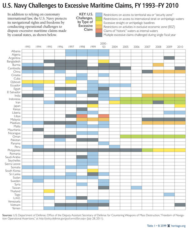
WASHINGTON (Reuters) - The U.S. military conducted "freedom of navigation" operations against 13 countries last year, including several to challenge China's claims in the South and East China seas, according to an annual Pentagon report released on Monday.
The operations were against China, India, Indonesia, Iran, Libya, Malaysia, the Maldives, Oman, the Philippines and Vietnam, the report said.
It did not specify how many such operations were conducted against each of those countries. The U.S. military carried out single operations against Taiwan, Nicaragua and Argentina, for a total of 13 countries, the department said in the two-page report.
The freedom of navigation operations involve sending U.S. Navy ships and military aircraft into areas where other countries have tried to limit access. The aim is to demonstrate that the international community does not accept such restrictions.
The U.S. military has repeatedly conducted operations disputing China's maritime claims in recent years and did so again in 2015, a year in which Beijing's island-building activity in the resource-rich areas of the South China Sea led to rising tensions in the region.
A U.S. guided-missile destroyer conducted a freedom of navigation patrol near one of China's man-made islands in the Spratly archipelago in October. U.S. military flights near the islands have been warned off.
U.S. Defense Secretary Ash Carter said the Navy would continue to operate in the region despite China's condemnation of the patrols.
China's Defense Ministry said in a statement on its website late on Monday that it was deeply concerned by such operations.
"The United States carries out militarization in the South China Sea in the name of freedom of navigation and overflight, threatens coastal nations' sovereignty and security and destroys regional peace and stability," the ministry said.
It made the comment in response to what it said were reports of recent U.S. military flights near Scarborough Shoal - known by Beijing as Huangyan Island - an area China seized control of after a stand-off with the Philippine coast guard in 2012.
Admiral Harry Harris, the head of U.S. Pacific Command, said this year the Navy would step up the freedom of navigation operations in the South China Sea because of concerns China is attempting to assert its dominance by building military facilities there.
U.S. freedom of navigation operations last year also challenged China's claims of jurisdiction in the airspace above its maritime Exclusive Economic Zone as well as restrictions it has tried to impose on aircraft flying through an Air Defense Identification Zone over the East China Sea.
The number of countries the United States challenged last year was down from 2014, when it targeted 19 countries. That was the largest number in more than a decade.
Iran and the Philippines have been the most frequently challenged countries over the years, mainly because they sit astride busy sea lanes whose use they have tried to limit or govern.
 

desicanuk

Regular Member
Joined
Nov 7, 2011
Messages
527
Likes
686
Posting error. Self deleted by desicanuk
 
Last edited:

AnantS

Senior Member
Joined
Jan 10, 2013
Messages
5,686
Likes
15,171
Country flag
That makes a very strong case for India to sign LSA, CISMOA and BECA. Order F 18, F 16 and beg for F 35.
 

Indx TechStyle

Kitty mod
Mod
Joined
Apr 29, 2015
Messages
18,289
Likes
56,242
Country flag
That makes a very strong case for India to sign LSA, CISMOA and BECA. Order F 18, F 16 and beg for F 35.
Actually, India is trying to step back from these agreements now.
Calling itself not ready.
Even of LEMoA is signed, there are very rare chances for CISOMA. that's a good thing.
Anyway,
BECA has not even chance to get signed over the national security issue from start of this matter.
Why brought that here?
BECA won't be there at any cost.
 

DingDong

Senior Member
Joined
Oct 24, 2014
Messages
3,227
Likes
8,528
Country flag
Seems like our government has either gone totally senile. We are having to pay for the inexperience of the current regime in handling of the foreign affairs, which are very different compared to winning elections in India. I can only hope that the "super-confident" Modi doesn't push us into a dangerous trap.

Just like some idiots in India invented terms like "Intolerance" to bring Congress back into the game, the US has invented a new phrase called "Freedom of Navigation" to maintain it's hegemony in the Asia-Pacific area.

Off late we have been reading many stories, which really are stories floated by the vested interests on the US payroll to gauge the public mood and government's reaction, for e.g. "Joint patrol in SCS", "US naval basing in A&N islands" etc. We need to be very careful because in long terms the Indian Ocean is of great strategic importance for the current and the aspiring superpowers (including India). We cannot forget historical lessons.
 

Indx TechStyle

Kitty mod
Mod
Joined
Apr 29, 2015
Messages
18,289
Likes
56,242
Country flag
Seems like our government has either gone totally senile. We are having to pay for the inexperience of the current regime in handling of the foreign affairs, which are very different compared to winning elections in India. I can only hope that the "super-confident" Modi doesn't push us into a dangerous trap.

Just like some idiots in India invented terms like "Intolerance" to bring Congress back into the game, the US has invented a new phrase called "Freedom of Navigation" to maintain it's hegemony in the Asia-Pacific area.

Off late we have been reading many stories, which really are stories floated by the vested interests on the US payroll to gauge the public mood and government's reaction, for e.g. "Joint patrol in SCS", "US naval basing in A&N islands" etc. We need to be very careful because in long terms the Indian Ocean is of great strategic importance for the current and the aspiring superpowers (including India). We cannot forget historical lessons.
No doubt US is a great power and at least for now, we can't challenge their hegemony.
Better is to play between them and communists. We are yet to be a mature power like them.

This freedom of navigation or banning Indian Launch service etc. is a daily circus played by US to show it's presence. Don't take it seriously. :D
 

garg_bharat

Senior Member
Joined
Dec 12, 2015
Messages
5,078
Likes
10,139
Country flag
@DingDong, seems you are the self-appointed smart person of india.

Extreme reactions like this typically comes from fools.

USA has been doing its thing for a long time. There is no need for overreaction. China has not shot down a us plane or sunk a ship so far. This shows it is just a game.
 

Razor

STABLE GENIUS
Senior Member
Joined
Feb 7, 2011
Messages
7,701
Likes
9,099
Country flag
What do they mean by "challenged navigational rights" wrt india?
Which geographical part of india?
 

pmaitra

Senior Member
Joined
Mar 10, 2009
Messages
33,262
Likes
19,594
What do they mean by "challenged navigational rights" wrt india?
Which geographical part of india?
Most likely counter anti-access/area-denial or counter-A2AD operations.

P.S.: Not sure why they say A2AD, instead of AAAD, or A3D.
 

Razor

STABLE GENIUS
Senior Member
Joined
Feb 7, 2011
Messages
7,701
Likes
9,099
Country flag
Most likely counter anti-access/area-denial or counter-A2AD operations.

P.S.: Not sure why they say A2AD, instead of AAAD, or A3D.
Wrt to china it is primarily those artificial islands china is building which the US, and many other countries, do not acknowledge.
The US considers the islands as international waters, I guess.

Are you saying that India is denying freedom of navigation in some international waters?

PS: I guess: (anti-access).... (Area-denial) => AA....AD => A^2.... AD => A2AD
 

pmaitra

Senior Member
Joined
Mar 10, 2009
Messages
33,262
Likes
19,594
Wrt to china it is primarily those artificial islands china is building which the US, and many other countries, do not acknowledge.
The US considers the islands as international waters, I guess.

Are you saying that India is denying freedom of navigation in some international waters?

PS: I guess: (anti-access).... (Area-denial) => AA....AD => A^2.... AD => A2AD
Is India doing any A2AD at all? Or is it that the US was simply using certain sea routes for regular transport, so as to tell everyone that this is international waaters, whether any country attempts A2AD or not. This is probably to discourage ambitious regional powers from getting too uppity. I don't know whether India has made any such attempt at all.
 

Razor

STABLE GENIUS
Senior Member
Joined
Feb 7, 2011
Messages
7,701
Likes
9,099
Country flag
Is India doing any A2AD at all? Or is it that the US was simply using certain sea routes for regular transport, so as to tell everyone that this is international waaters, whether any country attempts A2AD or not. This is probably to discourage ambitious regional powers from getting too uppity. I don't know whether India has made any such attempt at all.
Discourage, scare, threaten, send a message etc.
Like HS & NS was meant as a message to Stalin: "Nippon is off limits"

Just the local (oops i meam global) goonda and his tall tales.
 

amoy

Senior Member
Joined
Jan 17, 2010
Messages
5,982
Likes
1,849
FON operations are just USN's routine to challenge "excessive maritime claims". No big deal.

Most of the international community haven't got used to a life without US policing. And to do justice to the operations the world could have been a lot more dangerous had there been no US providing "security products" for the public altruistically.


Many countries have been freeloading. It's unthinkable if ...say US pulls out of Afghanistan or IOR. Better to have a few top-class bodyguards (P5 as multipolars) than leave it to 170+ who lack either the wherewithals or wills to patrol the world.
 
Last edited:

Indx TechStyle

Kitty mod
Mod
Joined
Apr 29, 2015
Messages
18,289
Likes
56,242
Country flag
FON operations are just USN's routine to challenge "excessive maritime claims". No big deal.

Most of the international community haven't got used to a life without US policing. And to do justice to the operations the world could have been a lot more dangerous had there been no US providing "security products" for the public altuistically.


Many countries have been freeloading. It's unthinkable if ...say US pulls out of Afghanistan or IOR. Better to have a few top-class bodyguards (P5 as multipolars) than leave it to 170+ who lack neither the wherewithals nor wills to patrol the world.
One extra country has will and has already been supported from around 80 others.
How about making P6? I mean include India as well. It has enough, at least to perform the duty of Policeman which you "top" class countries are referring.:biggrin2:
We are perfect option among G4 countries for UNSC.
BTW, we could have got it earlier. But the mind of Indian Socialists was boggled in 1955 who kicked out the opportunity.
 
Last edited:

Navnit Kundu

Pika Hu Akbarrr!!
Senior Member
Joined
Mar 22, 2016
Messages
1,394
Likes
3,097
What do they mean by "challenged navigational rights" wrt india?
Which geographical part of india?
This is as much a long standing legal battle on paper as it is a real one, it has an interesting history. I'll tell you the gist. As per international law, every nation can claim 20 miles beyond its land borders as its own territorial water (TW) and 200 miles as EEZ. There is a legal provision that allows a country to have its EEZ extended by making a formal application to the international body, which will in turn recognize it as such. In our case, we have 20 miles TW + 200 miles EEZ and we applied for 250 extra miles as extended economic zone. We continue to treat that total area in the radius of 450 miles as our de facto TW, which the US disagrees with and deliberately runs their warships through just to make a point. The point they are trying to make is "your extended economic zone is not your sovereign territorial water, let me plough my boat through it just to make sure you know"

PS : Legally, the US has the right to challenge India in our extended waters since extended economic zone is not the same as territorial waters and it cannot be considered an intrusion (or an act of war), but then again if you take into consideration the context that 'legally' isn't exactly the most reasonable benchmark of propriety, given that the current global order derives its legality from laws which were written by victors of WW, and these laws are inherently discriminatory in nature. So, take your pick. There is no one absolute version of truth in this case; In addition to actual military ability to access and control your claimed waters, legality, morality, geopolitics, nationalism, hegemony, alliances, security, trade, all variables are at play here, which make sea disputes more murky.

These are the mandatory 200 mile EEZ boundaries which all countries get.


Here's what our EEZ looks like :


Here's the extensions that we claim beyond our EEZ on our east and west coast.


Last edited:

Razor

STABLE GENIUS
Senior Member
Joined
Feb 7, 2011
Messages
7,701
Likes
9,099
Country flag
This is as much a long standing legal battle on paper as it is a real one, it has an interesting history. I'll tell you the gist. As per international law, every nation can claim 20 miles beyond its land borders as its own territorial water (TW) and 200 miles as EEZ. There is a legal provision that allows a country to have its EEZ extended by making a formal application to the international body, which will in turn recognize it as such. In our case, we have 20 miles TW + 200 miles EEZ and we applied for 250 extra miles as extended economic zone. We continue to treat that total area in the radius of 450 miles as our de facto TW, which the US disagrees with and deliberately runs their warships through just to make a point. The point they are trying to make is "your extended economic zone is not your sovereign territorial water, let me plough my boat through it just to make sure you know"

PS : Legally, the US has the right to challenge India in our extended waters since extended economic zone is not the same as territorial waters and it cannot be considered an intrusion (or an act of war), but then again if you take into consideration the context that 'legally' isn't exactly the most reasonable benchmark of propriety, given that the current global order derives its legality from laws which were written by victors of WW, and these laws are inherently discriminatory in nature. So, take your pick. There is no one absolute version of truth in this case; In addition to actual military ability to access and control your claimed waters, legality, morality, geopolitics, nationalism, hegemony, alliances, security, trade, all variables are at play here, which make sea disputes more murky.

These are the mandatory 200 mile EEZ boundaries which all countries get.
Ah, so now I see why I asked that Q in my previous post.
Two pieces of info, from your post, I didn't previously know :
1. India claimed (claims) 250 n.mi. extra EEZ (which is legal as per UNCLOS; extension of continental shelf)
2. India treats the 450 n.mi. (200+250) as TW.

I'm okay with that considering that many countries do that with some countries claiming entire seas.
Besides, as you say, legality is, well, not a concrete term. :)

PS: I think you meant 12 n.mi. as TW, not 20 mi.
 

Navnit Kundu

Pika Hu Akbarrr!!
Senior Member
Joined
Mar 22, 2016
Messages
1,394
Likes
3,097
Ah, so now I see why I asked that Q in my previous post.
Two pieces of info, from your post, I didn't previously know :
1. India claimed (claims) 250 n.mi. extra EEZ (which is legal as per UNCLOS; extension of continental shelf)
2. India treats the 450 n.mi. (200+250) as TW.

I'm okay with that considering that many countries do that with some countries claiming entire seas.
Besides, as you say, legality is, well, not a concrete term. :)

PS: I think you meant 12 n.mi. as TW, not 20 mi.
Nah, I meant 20 miles.

There are certain nuances and technicalities within that so it eventually ends up being 20 miles because if there's a submerged continental reef, then shall we consider it as deep sea or shallow waters and apply rules accordingly? and therefore an exception has been made for shallow reefs, which includes submerged reefs too, I think. There is a whole chapter on how to handle territorial claims of nations which have archipelago configurations. Shall it be treated as de facto land and given its own TW and EEZ or shall it be granted only a nominal TW? and so, in most cases they end up creating an exception called archipelago baseline (AB). And most of the times AB + TW roughly ends up being 20 miles. Because of the way ocean beds are formed, most of the times they are uneven and the dichotomy between land and sea isn't well defined so more than 95% of all land-sea borders have a natural continental shelf which ends up extending the AB. So the arithmetic ends up with supplementary TW extension from the legal 12 miles to de facto 20 miles. The earlier diagram was just a make shift one for school children, this one explains it better. The deeper interest you take in it, the more complicated and interesting it gets.


Consider all these rules, exceptions, islands, just to define a non disputed boundary. Imagine how complicated it gets when there are conflicting or overlapping claims? Our conflict with Myanmar and Bangladesh is one such example which will make anyone pull their hair.


The same game is being played out in Souch China Sea where China is treating the continental shelf as de facto land and then extending their argument from there to claim full sovereignty over those grey areas. Legally, there's no right or wrong and so if you observe carefully, no American propaganda channel (colloquially known as 'media') ever calls it a legal dispute. The only notion they keep harping on is "this behavior might lead to conflict", basically taking not a legal stance, but an moral one. It is a cryptic way of saying "we will beat you if you try to claim the grey area which we have illegally monopolized until now". Morally and dispassionately speaking, China has a greater right over that area than a foreign power from another continent, but because China has been so rude to its neighbors, they are happy to see China bleed. Compare China's territorial claims to the one which Japan made, in cohorts with their pimp, the USA, and China's transgressions seem trivial in comparison. Since claims over territorial waters extend themselves into Air Defense Identification Zone (ADIZ) protocols, it impacts the control of airspace as well.


The US allowed a large overlapping claim to arise between China and Japan be allowing (read : encouraging) Japan to redefine the territorial claims over Senkaku Islands. In fact, it was this imperialist aggression which provoked China to open up another front and that is how the South China Sea dispute came into being as a response to US douchbaggery, just like the Syria and Ukraine came into being, not the other way round, as the American media claims. They are trying to put the horse before the cart and sell snake oil to the world if they claim that intervention in Indian Ocean, SCS, Ukraine, Syria has got anything to do with freedoms and human rights. They are the one creating the problems by 'challenging' countries thousands of miles away from their continent.

Essentially all territorial water disputes until now followed the theme of "this land belongs to us therefore the adjacent waters belong to us", the paradigm shift that China has brought to the equation is "this water belongs to us, therefore the land belongs to us, therefore more water belongs to us". 'Land' here is loosely taken to assume continental reef, and they have dumped sand on the reef and pulled the reefs out of the legal grey area and into firm footing (pun intended) and as a corollary, extended their territorial water and ADIZ. Japan did exactly that, but American propaganda will never tell that side of the story.

Basically long story short, 'Freedom of Navigation' is to capitalism what 'Freedom of Religion' is to Christianity. The former is meant to extend their capitalist hegemony and the latter is meant to extend their Christian hegemony, they are misnomers which have nothing to do with the freedom of people who don't fall in the aforementioned coveted categories.
 

Navnit Kundu

Pika Hu Akbarrr!!
Senior Member
Joined
Mar 22, 2016
Messages
1,394
Likes
3,097
@Navnit Kundu : Interesting stuff. Gotta read more on this contentious topic.
Yup. That is why I said, this 'challenging' business has got more to do with the other factors than legality. The framework for all these laws, (including nuclear, space, biological, patent laws, human rights etc) was laid when the US was a rising global power, and therefore from the US point of view it was clear that if they had to rise, they would have to weaken the international order, which was seen as an impediment. Once they became a preeminent power, they started using these laws discriminatory against their potential challengers (to be fair even USSR joined them happily). Now that we are moving from a unipolar world to a multipolar one, the US is again strengthening these laws which they had earlier weakened for themselves to make it that much more difficult for new powers to rise. All these sea conflicts have to be looked at from that angle, otherwise what threat does the US face from the Indian ocean which it feels like challenging? are our fish and prawns conspiring to bring down Obama's government? are our crabs and octopus trying to sink US aircraft carriers? This is simply arrogant show of force to stick it to our face, nothing else.

Consider the ranges and speeds of missiles these days, 200 miles is nothing. And yet, a warship parked just 200 miles away from our shores is still technically considered to be in 'international waters', never mind the fact that they can hit all our vital targets in a matter of a few seconds if they want. Why is it that the Negro felt the need to park his aircraft carrier near Mumbai all the three times he visited India? to uphold law? Pffff..

Gun boat diplomacy, or in colloquial terms, blackmail.

There's a very interesting talk by a Singaporean diplomat of Indian ethnicity about the arrogance of the US. It gives a nice insight into the nuances of American moves, filled with his personal experiences (including one where he was threatened personally by an American diplomat).


Navnit Kundu

Pika Hu Akbarrr!!
Senior Member
Joined
Mar 22, 2016
Messages
1,394
Likes
3,097
This is the map of the region affected by so called Somali pirates :


One has to be pretty stupid to believe that a failed stated like Somalia with no economy or technological advancement can produce naval vessels which are able to hold off the most technologically capable navies of 70 nations which participate in the anti-piracy operations. What do they have, a Somali air craft carrier? Just look at that area, it's 20X the surface area of the entire country of Somalia.

Somalian pirates are to the ocean what Al Qaeda is on the land : American assets.

They're helping unkil hold on to strategic waters to prevent Iran, India and China from making any strategic inroads on Africa's east coast. First they create the pirates, then they create an anti-piracy coalition to battle the pirates, this is like America's war on terror all over again. One would hope that the US would use their mighty navy to tackle the Somali pirates, but what do they do? challenge India. Well done.
 

Latest Replies

Global Defence

New threads

Articles

Top