Geopolitics mistakes wich were the origin of the conflict of Kashmir
The causes of the conflict of Kashmir were many, which you will be able to see at the end of this document - the access to the specific and better documented sites. This Web site proposes a thought of the particular topography of Kashmir and which were, at the time, the root of the conflict of Kashmir.
Geography is a means of knowledge which also takes into account the heights of the mountains, the lengths of rivers, etc. the social and economic situation of the time, so that it basically, meets a fundamental need which allows to act on the ground. Geography makes use of this information and it's, more or less high degree of accuracy, enables the people to have an important advantage in a conflict. To behold the geographic keys is to have the base of geopolitics and the military strategy. The punishment of a geographical ignorance is inevitably war. The particular topography of Kashmir, extremely mountainous, had unevitable consequences on the problems of an already complicated partition.
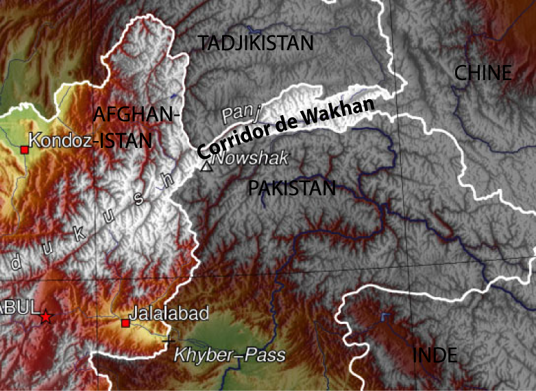
At the time of the partition, the principal economic situation of Kashmir was forgotten because it was less necessary to seek the richness in its earth, rather than in the immense and unexpected richness that the mountains can offer - thus water was the forgotten element of the partition. By declaring that Kashmir was "the jugular vein of Pakistan" Jinnah underlined a geographic fact of considerable strategic importance. In these areas, water is not only "necessary" to life, it is "life itself" and this expression becomes very important especially at this latitude which is equal to the deserts of Baloutchistan, the Rajasthan and Takla makham, where the rainfall is even less than in the Sahara. The partition of 1947 deprived Pakistan of its river sources of Penjab of Jelhum, Chenab, the delighted one, Beas and Sutlej - rivers which gave birth to the name of the Penjab province. These five river, the sources are in Kashmir, are vital for the economy of the country. The Indus basin in which the majority of the Pakistani population lives, concentrates all the richness of the country and it is supplied by water of various rivers and their affluents. This richness, as well as the formidable icecap of the northern areas, comes from one and the same origin, Kashmir. Without speaking about the sacred character of the Indus river, to conquer these highlands, would allow Pakistan to control the whole Indus flow whose source can be found on the annexed Tibetain grounds of the Chinese ally. The speed by which the partition was set up as well as the geographical ignorance of North Kashmir at that time in the middle of the last century, probably was of great importance in the conflict of Kashmir which opposed India, China and Pakistan. On August 15, 1947, date of the partition, the geography was not better known than in 1937, when Shipton wrote his book "Blank on the map" the title describes the sorry character of these forgotten Arctic areas by humans. The layout of the borders between India and Pakistan, at the time of the partition, was decided upon by a special commission between the 21st and the 24th of July 1947 in only 11 days. These 11 days were not long enough for the commission to decide on the Kashmir borders, whose geography was, in many cases, always vague or even unknown. The considerable amount of information reported by the Survey of India, followed by explorations of Goldwin Austen, Conway of Baltoro, Shipton in the areas of Panmah, Shaksgam and Biafo, the Bullock couple in the areas of Hispar and Siachen, were all ignored. The first existance of Kashmir is the probable consequence of this ignorance.
In 1962, the area of Aksin Shin, remote aand backwards, was added to India for the same reasons. This negligent Indian strategy, which lead to the loss of their territory, because, at first sight, it seemed without economic value, will have serious consequences to the conflict of Kashmir especially regarding the credibility of the Indian military forces.The origin of the second Pakistani Indo war and the acceleration of the nuclearisation of the conflict of Kashmir. Lastly, during the crisis of Kargil in 1999, India had much trouble to get rid of the Pakistani forces as well as the infiltrated Kashmiries, because, with their excellent knowledge of their homeland and good resistance to altitude, they held an advantage over the Indian military. These exemples particulary show up to what point geographic knowledge is of major importance when war is at stake.This had unquestionable consequences on the conflict of Kashmir especially in this part of the world where ground is very difficult.
Geographers in Kashmir
Geographical science, when shared with the art of war, is in the interest to control territory. The obvious link between geography and war is the cartography. Already in the 19th century, the British Raj, wanting to affirm his domination in Asia, trusted the British officers who travelled the remote mountains and back are as of the north, with the cartography of the Indian sub continent and its borders. They were long, difficult and perilous missions. Sir Godwin Austen, as well as George Everest were Survey Officers of India. They devoted their lives to writing pages of figures, going through cold and inhospitable places, sometimes disguised as natives, sometimes illness took over, but they always continued to add their contribution to this enormous task, the establishment of a detailed chart of the sub continent. From the south of India in 1808, the great Survey Officers progressed step by step. The Everest (Peak XV) was only identified in 1848 and K2 in 1856, after half a century of exploration.
G. Hayward
In the 19th centuary, all of the sheltered kingdoms of the Himalayas were prohibited, for eg, Tibet, Nepal, Bhutan and Sikkim as well as Kashmir. One can measure the exclusiveness of these regions and the difficulty of going through their mysteries by reading "Voyage in Tibet" written by Alexandra David Neel and also "Annapurna, first 8000" where Herzog was the first one of the Westerners to open the doors of Kathmandu in 1950. The high, remote back valley of Kashmir, which have a more septtentrional climate than the Himalayas in the South and are closed by snow during the winter, are separated by unclimable mountains. They sheltered various populations who lead a self-sufficient life and were not very open to dialogues. The rulers and the kings of these high valleys made war from one valley to another. The tradition of armed robbery damaged their reputation and brought misfortune to the travellers who went to these high valleys. Karakorum meant " the black mountains", which refers less to their colour than to the danger of the paths that the merchants of the silk road were obliged to use. These rulers and heads of tribes kept and strongly protected geographical information which had come into their valleys. The geographicers were then compared to spies. George Hayward, explorer and geographer, paid with his life for his curiosity. He was assassinated in 1870 in Darkot by mir it Walli who worried about the disclosure of the cartography of his valley. These mirs still reigned as masters of their valleys in 1947, at the time of the partition, the country was still completely closed in. These difficulties made good geographic knowledge impossible regarding these highlands and consequently the good partition of Kashmir of 1945, was wrong.
Alexandra David Neel
It is difficult to find precise maps of the Kashmir area, they are held by the major states of the armies for obvious strategic reasons. It is still the case in all the massives of the Himalayas. It is curios to note that cartography can be used as a propaganda media, which makes it very political. It is enough to consult several maps of the Indian sub continent to notice that at what point the borders of the 3 countries in Kashmir are changing. Recently, to please the 3 opponents, the World Bank "disadvised" its cartographic Service not to produce maps of the Indian peninsula which could be too precise and show the Kashmir area. Another example, the official altitude of K2 of 8611m was questioned in 1976 by a Pakistani expedition which recalculated its altitude up to 8760m. Another expedition, American this time, recalculated its altitude with the help of a satellite to 8858m, i.i. higher than Everest. For the highest mountain top not to be in Nepal any more (a country politivcally dominated by India) but in Pakistan has obvious political repercussions (the altitude of K2 was later recalculated by Italians and was closer to that of origin). Recently, India opened for expeditions, the powerful tops of the eastern Karakorum, even tough there are violent arguments about this. Expeditions must obligatorily be composed of the Indian army. To conquer the tops, and to make false altitudes in order to represent political borders without definition, are sometimes necessary excercises and part of a means to obtain political goals. The war that the 3 opponents delivered in Kashmir is also part of this manipulation and we may suggest that the territory is also part of a psychological war.
The real dispute about Siachen territory really started when India worried about the climbing permits granted to the mountaineers by the Pakistani authorities, in the region that was not yet clearly defined in the 1980 maps. India saw a means to expand and started to train its picked groups of soldiers in the 80ties in the arctic, having their men go through hardships and extreme conditions, hardships based on cold weather conditions (this is still the case today as part of the Indian manoeuvres will take place jointly with their US partners in Alaska). After the Indian invasion of the Siachen glacier, Pakistan precisely calls this as " cartographic aggression " coming from India, indirectly pointing out the importance of cartographic gaps of these remote areas and the consequences of a never-ending conflict of Kashmir. Now it is necessary for the bellingent to defend the nation up to the far territories of its ice.
An extraordinary event was that in 1947 or 1949 none of the governments nor the superior officers who set up and co-signed the line of control (LOC) on the topographic maps, thought it necessary to go as far as the Chinese border. Did they have the geographical knowledge of these remote areas to be able to decide and trace some kind of a border? Probably not. The written agreement only states that after the NJ9842 point, the line goes as "far as the north up to glaciers". This huge inaccuracy leads to the dispute of the two countries who intend to become owners of this area, 35 yrs later, the Siachen glacier in 1984.
The Siachen war started precisely where the geographical maps ended in the north of the NJ9842 point. India claimed its border as from the high mountains of Saltoro up to the top of Gasherbrun (8068m) by going through the strategic passes of Bilafond and Sia. The Siachen glacier is therefore Indian according to Delhi, based on a hydrographical argument: the Nubra river that flows downstream from Siachen and that irrigates Indian Ladakh, must belong to them up to its source. Pakistan, however, demands the border set up in 1949, which means, the one that separates the Siachen glacier into two, the upstream belonging to them by right.
Today, the new military technics of observation (in particular satellite observation, drones,"¦) and the reinforcement of communication means, improve the monitoring of the control line and stabilize the concerned forces. Invations, similar to those of 1962 and even 1999, are no longer possible, even more so because these extremely mountainous areas cannot be used as fast and significant openings. It only allows the infiltration of small groups of armed men whose terrorist activity in Kashmir is still currently more significant either – befor or after the winter, when the high passes are accessible after the melting of snow.
Not to know all about this mountainous area was probably one of the many causes of the conflict of Kashmir. Perhaps the enclosure and the very mountainous topography of this part of the world will, in the future, avoid some misunderstandings. Today, in a conflict context, geographical information refering to Kashmir is kept secret defense. Certain territories, like the glacier of Siachen, the solid mass of Kailash or Aksin Chin, remain of very difficult access, they are isolated by mines and the control line remains solid. They are much more accessible to a satellite exploration than to a human exploration, it is always "Blank on the Map".