
Indian Navigation Constellation (NAVIC) aka IRNSS
- Thread starter Singh
- Start date
More options
Who Replied?sorcerer
New Member
- Joined
- Apr 13, 2013
- Messages
- 26,919
- Likes
- 98,474
India gets devices to indigenously map its terrain from space
3-4 minutes
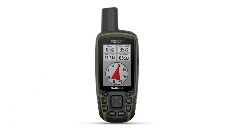
Nellore: Garmin, a renowned manufacturer of navigational products, has recently launched in India NavIC-enabled handheld devices GPSMAP 65s and GPSMAP 66sr, which enhance accuracy and availability of signals irrespective of the terrain.
Acknowledging Garmin’s initiative to incorporate NavIC in the two GPSMAP 65s and 66sr handheld devices, Indian Space Research Organisation ISRO has asked the organisation to make NavIC an integral part of all its upcoming satellite navigation-based devices being launched in India.
 www.deccanchronicle.com
3-4 minutes
Nellore: Garmin, a renowned manufacturer of navigational products, has recently launched in India NavIC-enabled handheld devices GPSMAP 65s and GPSMAP 66sr, which enhance accuracy and availability of signals irrespective of the terrain.
Acknowledging Garmin’s initiative to incorporate NavIC in the two GPSMAP 65s and 66sr handheld devices, Indian Space Research Organisation ISRO has asked the organisation to make NavIC an integral part of all its upcoming satellite navigation-based devices being launched in India.
India gets devices to indigenously map its terrain from space
NavIC has been developed for India to become self-reliant without being dependent on foreign navigation technologies
RoaringTigerHiddenDragon
New Member
- Joined
- Sep 5, 2020
- Messages
- 4,132
- Likes
- 17,621
I think this is a great idea by the telecom Secretary. The government must move on this so NAVIC gets popular:

 www.dqindia.com
it is great to see NAVIC being compulsory for commercial vehicles. This needs to be advertised and talked about more.

 www.summachar.in
ISRO NavIC Should be Made Mandatory for Mobiles Released in Indian Market: Anshu Prakash, Telecom Secretary
ISRO NavIC is already being supported by mobile chipset manufacturers like Qualcomm, MediaTek and Broadcom across various chipset platforms
it is great to see NAVIC being compulsory for commercial vehicles. This needs to be advertised and talked about more.
Govt Mandates NavIC-based Vehicle Tracking System | SUMMACHAR
Navigation with Indian Constellation (NavIC) based vehicle tracking system developed by India has been mandated to be equipped in all commercial vehicles. These trackers are being developed by as many as 75 companies and are already equipped into thousands of commercial vehicles.
www.summachar.in
Swesh
New Member
- Joined
- Jan 12, 2020
- Messages
- 3,520
- Likes
- 12,185
Elena Geo Systems
Leading NavIC product manufacturing company pioneers innovative solutions using India's indigenous satellite navigation technology.

Lt Col V S Velan, an Indian Army Veteran, has been working in GNSS domain from 1998. He has been associated in Navic / IRNSS, since its inception in June 2008. He was the System Manager for development of monitoring system and GIS for the armed forces during 2003-2011. He had taken pre-mature retirement in 2011 to pursue research in this domain. Elena's products are result of research combined with his in depth domain knowledge and experience.
NavIC Drone Navigation Unit
Elena NavIC drone navigation unit is a small form factor, light weight device made especially for drones. It is an high-performance Multi GNSS positioning device that is capable of tracking all global navigation systems. Concurrent reception of L1 and L5 band signals mitigates the multi-path delay and achieves sub-meter position accuracy. The module is a complete receiver miniaturised to enable drone navigation. It uses Indian algorithms for stable and accurate positioning.This is supplied along with dual / tri band active antenna
Attachments
-
617.3 KB Views: 227
Swesh
New Member
- Joined
- Jan 12, 2020
- Messages
- 3,520
- Likes
- 12,185
Elena drone navigation broucher
Attachments
-
471.3 KB Views: 280
Swesh
New Member
- Joined
- Jan 12, 2020
- Messages
- 3,520
- Likes
- 12,185
Map Server
Elena server has own map framework. It takes in map data from varied sources, such as Google map and Open Street map, include in the traced data and serve it to the user. This server works independent of the map data server.


Elena server has own map framework. It takes in map data from varied sources, such as Google map and Open Street map, include in the traced data and serve it to the user. This server works independent of the map data server.
Swesh
New Member
- Joined
- Jan 12, 2020
- Messages
- 3,520
- Likes
- 12,185
@Indx TechStyle @Vamsi @Haldilal @AkulaAlso 5 no of geo navigation satellites approved for geo constellation. And 7 more Irnss to be launched to extend range of navic which is 1500 km now and proposed to be 3000 in future
- Joined
- Apr 29, 2015
- Messages
- 18,416
- Likes
- 56,946
Isro, whose NavIC system is yet to penetrate the commercial market or find extensive deployment otherwise, is in the process of strengthening the programme with new generation satellites.
Elaborating on the sidelines of the event, he said: "Of the seven NavIC satellites, some have failed, we need to replace a few and work on this is happening. However, we've also realised that to make it more effective, we need to have satellites in the L1 band and in a different orbit. We'll also need to look at security of signals."
The present constellation of NavIC satellites operate in the L-5 and S bands and are placed on a geostationary orbit (GEO).
"...We'll need satellites in the L-1 band for the transition from a regional satellite to a global one. For the same reason we also need NavIC satellites in a MEO (medium Earth orbit), which will happen. We have five satellites under production," Somanath added.

GSLV-Mk3 production must be increased to 6/yr from 2, Isro strengthening NavIC: Somanath - Times of India
Science News: NEW DELHI: Close on the heels of its first commercial mission, Isro chairman S Somanath said India will need to increase the production capacity of of.
- Joined
- Apr 29, 2015
- Messages
- 18,416
- Likes
- 56,946
Swesh
New Member
- Joined
- Jan 12, 2020
- Messages
- 3,520
- Likes
- 12,185
Key word is it's industry that want delay adoption of NAVIC post elections in hope of...... Isro and govt is ready for adoption
Swesh
New Member
- Joined
- Jan 12, 2020
- Messages
- 3,520
- Likes
- 12,185
On the update on NavIC constellation, he said India has to launch only three to make the constellation complete. Out of the eight NavIC satellites that have been launched, one is not working and in some others, the atomic clock is not functioning.
"We are working to get the Indian government's permission to launch one NavIC satellite next February. We are also looking at the long term plan. We are building five more NavIC satellites as replacement for the existing ones. The five satellites will have a new frequency for civilian use. Further the communication security is beefed up for
"We are working to get the Indian government's permission to launch one NavIC satellite next February. We are also looking at the long term plan. We are building five more NavIC satellites as replacement for the existing ones. The five satellites will have a new frequency for civilian use. Further the communication security is beefed up for
- Joined
- Apr 29, 2015
- Messages
- 18,416
- Likes
- 56,946
Anything on GINS and total number of satellites in it?
Swesh
New Member
- Joined
- Jan 12, 2020
- Messages
- 3,520
- Likes
- 12,185
Nothing but they mentioned extending range of navic by launching 5 new sats after launching 3 replacement satellitesAnything on GINS and total number of satellites in it?
- Joined
- Apr 29, 2015
- Messages
- 18,416
- Likes
- 56,946
GINS mentioned an aim of a constellation of 24 satellites for global navigation. That's less than US and China's 32 satellites and equal to Russia's 24 satellites.Nothing but they mentioned extending range of navic by launching 5 new sats after launching 3 replacement satellites
Articles
-
 India Strikes Back: Operation Snow Leopard - Part 1
- mist_consecutive
- Replies: 9
-
Aftermath Galwan : Who holds the fort ?
- mist_consecutive
- Replies: 33
-
 The Terrible Cost of Presidential Racism(Nixon & Kissinger towards India).
- ezsasa
- Replies: 40
-
Modern BVR Air Combat - Part 2
- mist_consecutive
- Replies: 22
-
Civil & Military Bureaucracy and related discussions
- daya
- Replies: 32