Agni V Missile
- Thread starter Daredevil
- Start date
More options
Who Replied?sayareakd
New Member
- Joined
- Feb 17, 2009
- Messages
- 17,734
- Likes
- 18,953
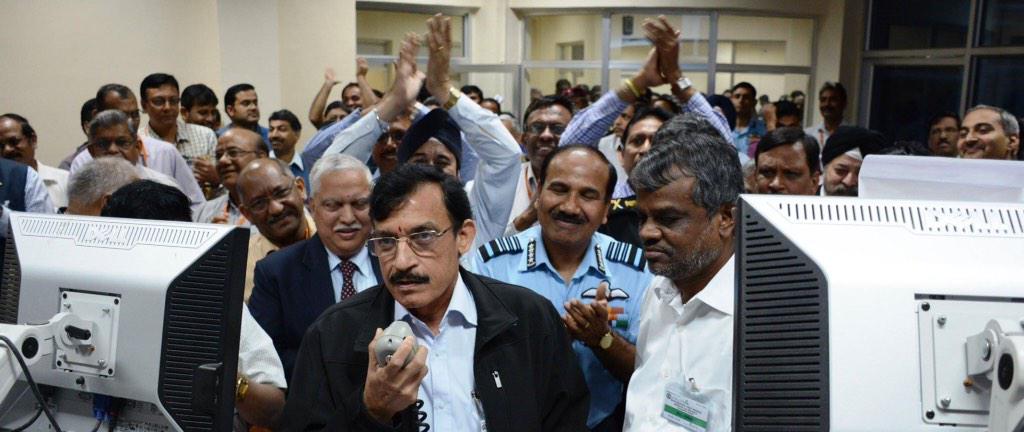
Most of the guys look older then Dr. Chandra............From the launch control center:

Free Karma
New Member
- Joined
- Oct 3, 2013
- Messages
- 2,372
- Likes
- 2,601
I think it's the hair (or lack of it in the background )Most of the guys look older then Dr. Chandra............
- Joined
- Oct 3, 2009
- Messages
- 11,117
- Likes
- 14,550
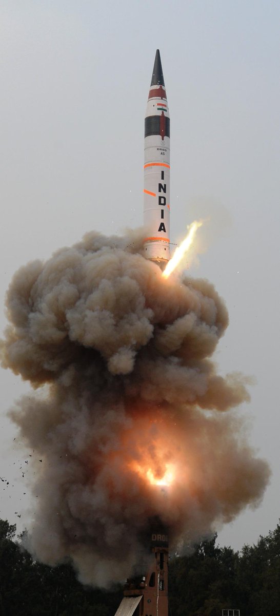
February 02, 2015: The Agni V ballistic missile, India's longest range nuclear delivery system, enters service by the end of this year. At this stage, top sources say development test routines are complete, with the system to be handed over to the Strategic Forces Command (SFC) to populate deterrent units in the country. The road-transportable canisterised system, which will be standard on the Agni V going forward is ready in all respects for deterrent duty, outgoing DRDO chief Dr Avinash Chander has indicated. Top sources said that there was the possibility of one final test being conducted towards the middle of this year to fine tune certain navigational aspects of the missile's performance, but that they were satisfied with the outcome of the cold launch from a hermetically sealed canister that for the first time provides immense deployment flexibility and survivability. With the Agni III already in service, the Agni V will replace it as the longest range strategic weapon in India's nuclear arsenal. The Agni IV has already been inducted into service too. According to DRDO, the earlier two flights of Agni V, fully successful, were in open configuration and had already proved the missile. "Saturday's launch from a canister integrated with a mobile sophisticated launcher, was in its deliverable configuration that enables launch of the missile with a very short preparation time as compared to an open launch. It also has advantages of higher reliability, longer shelf life, less maintenance and enhanced mobility," the DRDO said in a statement.
Agni V Enters Service This Year - SP’s Exculsive
Agni V Enters Service This Year - SP’s Exculsive
- Joined
- Aug 3, 2010
- Messages
- 4,654
- Likes
- 8,370
I was thinking about the cap of the canister of A5.
So i watched the video again.

It has rubber sheet type stuff for selling the canister.
Look at the screen shots. It shows the expansion of the rubber sheet seal, then the missile cone cut it open and it come up. You can see the rubber sheet still hanging on to the canister.....
I am loving this video, every time i see it. Find something new.
Still looking for the cold launch motor. It has hidden in exhaust.
Always finding the small things, Saya?
 :thumb:
- Joined
- Aug 3, 2010
- Messages
- 4,654
- Likes
- 8,370
From the launch control center:

Looks determined, has something to prove, especially after recent events.
Should have been an dramatic explosion in the background, "---- yeah" moment.
Last edited:
sayareakd
New Member
- Joined
- Feb 17, 2009
- Messages
- 17,734
- Likes
- 18,953
This is when he formally says on public address system "Test Sucessful". Since they all know it before had on control room screens. Annousement for those who are outside the control room.Looks determined, has something to prove, especially after recent events.
Should have been an dramatic explosion in the background, "---- yeah" moment.
1. the main power which pops up the missile is the hot/high pressure gas created by the Gas Generator on the bottom of missile canister. you can see the flame-out on the top of the canister.
2. the thing on the bottom of the missile is not 'booster' but a heat shield to protect the missile against that hot/high pressure gas and pass the equilibrated pressure to the missile during the ejection phase in the canister...
3. there is a small Lateral engine/Gas Generator on the heat shield to push the shield away the missile , then the missile began the ignition
kurup
New Member
- Joined
- Sep 22, 2012
- Messages
- 569
- Likes
- 1,287
This was the NAVAREA issued for this test ........... can somebody please decode it ?? @sayareakd @shiphone
INDIAN OCEAN AND BAY OF BENGAL (.) CHARTS 31 351 352 3010 3017 INT 71 INT 706
(.) EXPERIMENTAL FLIGHT TRIAL SCHEDULED FROM ITR LAUNCH ON 310230-310630 UTC
JAN AND 010400-010800 AND 020400-020800 UTC FEB 15 IN AREA BOUNDED BY
AREA -1
(A) 20-48.36N 087-02.58E (B) 19-03.39N 086-26.30E
(C) 06-22.00S 087-05.29E (D) 06-16.38S 089-21.89E
(E) 05-59.53S 091-37.58E (F) 19-11.29N 088-02.33E
(G) 20-48.76N 087-07.40E
AREA - 2
(A) 15-24.16S 087-38.14E (B) 25-19.43S 088-26.10E
(C) 25-10.82S 091-02.58E (D) 24-53.78S 093-37.96E
(E) 14-59.66S 092-35.90E
2. NO OVER FLIGHT AND SHIPPING PERMITTED IN DANGER ZONE
3. CANCEL THIS MSG 020900 UTC FEB 15
Last edited by a moderator:
- Joined
- Jul 12, 2014
- Messages
- 32,663
- Likes
- 151,106
Available in a map format in our forum somewhere, sorry don't remember the thread...This was the NAVAREA issued for this test ........... can somebody please decode it ?? @sayareakd @shiphone
INDIAN OCEAN AND BAY OF BENGAL (.) CHARTS 31 351 352 3010 3017 INT 71 INT 706
(.) EXPERIMENTAL FLIGHT TRIAL SCHEDULED FROM ITR LAUNCH ON 310230-310630 UTC
JAN AND 010400-010800 AND 020400-020800 UTC FEB 15 IN AREA BOUNDED BY
AREA -1
(A) 20-48.36N 087-02.58E (B) 19-03.39N 086-26.30E
(C) 06-22.00S 087-05.29E (D) 06-16.38S 089-21.89E
(E) 05-59.53S 091-37.58E (F) 19-11.29N 088-02.33E
(G) 20-48.76N 087-07.40E
AREA - 2
(A) 15-24.16S 087-38.14E (B) 25-19.43S 088-26.10E
(C) 25-10.82S 091-02.58E (D) 24-53.78S 093-37.96E
(E) 14-59.66S 092-35.90E
2. NO OVER FLIGHT AND SHIPPING PERMITTED IN DANGER ZONE
3. CANCEL THIS MSG 020900 UTC FEB 15
Last edited by a moderator:
saik
New Member
- Joined
- Dec 25, 2014
- Messages
- 62
- Likes
- 28
www .gps-coordinates .net
A - Dhamara Road, Dhamara, Odisha 756171, India
Latitude : 20.81 | Longitude : 87.049444
B - I am lazy to enter
C ...find it out from this link
[how do I link a URL?]
D - is somewhere near Oz [3/4th way from Deigo Garcia to Aus]
A - Dhamara Road, Dhamara, Odisha 756171, India
Latitude : 20.81 | Longitude : 87.049444
B - I am lazy to enter
C ...find it out from this link
[how do I link a URL?]
D - is somewhere near Oz [3/4th way from Deigo Garcia to Aus]
Last edited:
sayareakd
New Member
- Joined
- Feb 17, 2009
- Messages
- 17,734
- Likes
- 18,953
This was the NAVAREA issued for this test ........... can somebody please decode it ?? @sayareakd @shiphone
INDIAN OCEAN AND BAY OF BENGAL (.) CHARTS 31 351 352 3010 3017 INT 71 INT 706
(.) EXPERIMENTAL FLIGHT TRIAL SCHEDULED FROM ITR LAUNCH ON 310230-310630 UTC
JAN AND 010400-010800 AND 020400-020800 UTC FEB 15 IN AREA BOUNDED BY
AREA -1
(A) 20-48.36N 087-02.58E (B) 19-03.39N 086-26.30E
(C) 06-22.00S 087-05.29E (D) 06-16.38S 089-21.89E
(E) 05-59.53S 091-37.58E (F) 19-11.29N 088-02.33E
(G) 20-48.76N 087-07.40E
AREA - 2
(A) 15-24.16S 087-38.14E (B) 25-19.43S 088-26.10E
(C) 25-10.82S 091-02.58E (D) 24-53.78S 093-37.96E
(E) 14-59.66S 092-35.90E
2. NO OVER FLIGHT AND SHIPPING PERMITTED IN DANGER ZONE
3. CANCEL THIS MSG 020900 UTC FEB 15
as ezsasa said map was posted on thread. Regarding decoading it.
Jan 31. 2:30 to 6:30 feb date 01 time 4:00 to 8:00 same for feb 02.
Rest are cordinates on map posted previously.
Last edited by a moderator:
kurup
New Member
- Joined
- Sep 22, 2012
- Messages
- 569
- Likes
- 1,287
That map is no more avaliable .Available in a map format in our forum somewhere, sorry don't remember the thread...
kurup
New Member
- Joined
- Sep 22, 2012
- Messages
- 569
- Likes
- 1,287
Actually I was more interested in the map ..... That map you are saying is no more avaliable .as ezsasa said map was posted on thread. Regarding decoading it.
Jan 31. 2:30 to 6:30 feb date 01 time 4:00 to 8:00 same for feb 02.
Rest are cordinates on map posted previously.
I would have decoded it but my Google earth is showing some problems .
sayareakd
New Member
- Joined
- Feb 17, 2009
- Messages
- 17,734
- Likes
- 18,953
https://lh6.googleusercontent.com/-...8/JbB4CD4-uew/s599/111259es0wduwann3zd3j0.pngActually I was more interested in the map ..... That map you are saying is no more avaliable .
I would have decoded it but my Google earth is showing some problems .
kurup
New Member
- Joined
- Sep 22, 2012
- Messages
- 569
- Likes
- 1,287
But that is from the second test conducted on Sep 15 2013 .
this thread--http://defenceforumindia.com/forum/strategic-forces/65872-next-test-agni-5-missile-mirv-canister-2.html, #30 post...but it seems that there was something wrong with my earlier image link...so tried to upload it again...with the measure tools of that source, the total length on the map is 5K kms...This was the NAVAREA issued for this test ........... can somebody please decode it ?? @sayareakd @shiphone

Last edited by a moderator:
Articles
-
India Strikes Back: Operation Snow Leopard - Part 1
- mist_consecutive
- Replies: 9
-
Aftermath Galwan : Who holds the fort ?
- mist_consecutive
- Replies: 33
-
The Terrible Cost of Presidential Racism(Nixon & Kissinger towards India).
- ezsasa
- Replies: 40
-
Modern BVR Air Combat - Part 2
- mist_consecutive
- Replies: 22
-
Civil & Military Bureaucracy and related discussions
- daya
- Replies: 32


