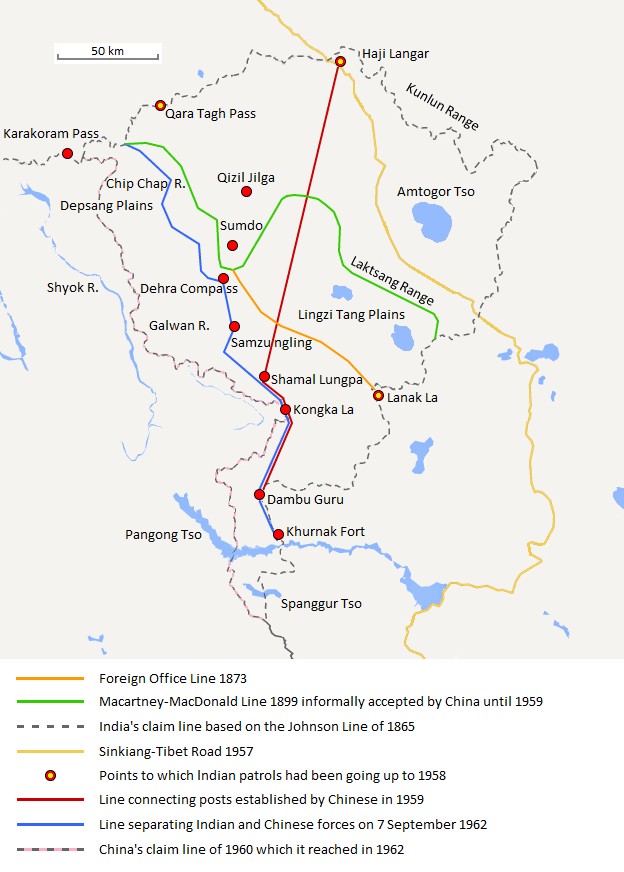
William Johnson, a civil servant with the
Survey of India proposed the "Johnson Line" in 1865, which put Aksai Chin in Kashmir. In 1893, Hung Ta-chen, a senior Chinese official at
Kashgar, handed a map of the boundary proposed by China to
George Macartney, the British
consul-general at Kashgar.
[1] This boundary placed the Lingzi Tang plains, which are south of the Laktsang range, in India, and
Aksai Chin proper, which is north of the Laktsang range, in China. Macartney agreed with the proposal and forwarded it to the British Indian government.
[2] The British presented this line, known as the Macartney–MacDonald line, to the Chinese in a note by Sir
Claude MacDonald.
[2] The Qing government did not respond to the note, and the British took that as Chinese acquiescence. Although no official boundary had ever been negotiated, China believed that this had been the accepted boundary.
[2][3] The Macartney–MacDonald Line had been tacitly accepted by China [3] as the boundary until Chinese Premier Zhou Enlai confirmed the new Chinese claim line to his Indian counterpart, Jawaharlal Nehru in 1959.
The Macartney–MacDonald Line is a partial basis of the
Sino-Pakistan Agreement. It has been suggested that a solution to the
Sino-Indian border dispute could also be based on the Macartney–MacDonald Line.
[3][4]

 Check it out......
 .
.