- Joined
- Oct 3, 2009
- Messages
- 11,115
- Likes
- 14,530
BSF - India's First Line of Defence


Writing for fulfilling requirement of 30 characters.'Laser walls' activated along India-Pakistan border to plug gaps in vigil
The 'laser walls' are armed with night and fog operability tools
HIGHLIGHTS
• The decision to install 'laser walls' taken by BSF 2 years ago
• They will help guard areas where barbed wire fencing can't be installed due to treacherous terrain
• Satellite-based signal command system used for montoring; these walls armed with fog operability tools
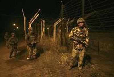
NEW DELHI: A dozen "laser walls" have been made operational along the India-Pakistan international border in Punjab to plug the porous riverine and treacherous terrain and keep an effective vigil against intruders and terrorists exploiting the frontier areas to cross over.While eight infra-red and laser beam intrusion detection systems are "up and working" along as many vulnerable and sensitive areas of the international border (IB) in Punjab, four more will be operationalised in the next few days, a senior official of the Border Security Force (BSF) said.The "laser walls" or fence are being monitored by the BSF which guards the Indo-Pak border in Jammu and Kashmir, Punjab, Rajasthan and Gujarat.The decision to install these laser walls was taken by the BSF two years ago keeping in mind the vulnerability of the border in these areas as barbed wire fencing could not be installed in many infiltration prone areas due to treacherous terrain or marshy riverine topography.After the Pathankot terror attack, where it was suspected that terrorists crossed over from Pakistan by breaching the border from Bamiyal area in Punjab, Union home ministry and BSF sped up the deployment and activation of these walls along the long and winding border.A total of 45 such laser walls will be installed in these areas along the international border in Punjab and Jammu, a blueprint prepared in this regard and accessed by PTI said.According to the blueprint, the BSF along with a team of technical experts will be conducting a pilot project for deploying "technological solutions" for effective border guarding at two "sensitive" riverine stretches in Jammu sector which entails deployment of smart sensors to pick up suspected movements along the international border."The laser walls have started working and their functioning is being monitored. Preliminary results in detecting illegal movements are encouraging," the official said.He said sensors were being monitored through a satellite-based signal command system and armed with night and fog operability tools.Apart from these, four other pilot projects of similar kind in stretches of 30-40 kms of international border in Jammu and Gujarat and one in West Bengal along Indo-Bangla border have been approved by Home Ministry to secure Indian borders effectively."Work on them will begin by next month," he said.
After the Pathankot incident, BSF had deployed an additional battalion (about 1,000 men) in Punjab sector even as it has increased the number of its ambush operations and patrol in the area.The BSF is also considering deploying at least four more battalions in Punjab and Jammu border areas as a second-tier of defence after withdrawing these units from the Line of Control.
Quietly, without fanfare, India is taking concrete steps to squeeze Pakistan’s terror machine. The strategy is simple and should have been implemented years ago. The objective: to make the 2,900-km-long Line of Control (LoC) and International Border (IB) with Pakistan impervious to terrorist infiltration.
India’s mortar-for-mortar policy on the LoC has silenced Pakistan’s guns. Since September 2015 there have been few incidents of cross-border firing by the Pakistan Rangers. In earlier years ceasefire violations were endemic. Villagers near the LoC lived in constant fear of Pakistani shelling. Several hundred lives – civilian and military – had been lost over the years to unprovoked Pakistani firing.
Terrorist infiltration, however, remains a serious problem. The Gurdaspur and Pathankot attacks exposed the vulnerability of India’s high security and civilian targets to terrorists pushed across the border by Pakistani army regulars with modern weaponry and provisions to last for days.
The new steps to stop terrorist attacks like Pathankot are promising. They rely on technology and will collaterally help curtail cross-border narcotics smuggling into Punjab.
The plan envisages building a high-tech Comprehensive Integrated Border Management System (CIBMS). The system will have a multi-layered protective shield. It will cover India’s entire western land border from Gujarat to Jammu and Kashmir.
CIBMS technology is similar to Israel’s security shield on its sensitive borders with several Arab countries. The high-tech equipment includes thermal imaging devices, 360 degree battlefield surveillance radar, night vision cameras, laser barriers and underground monitoring sensors.
The CIBMS would be linked 24x7 to multiple control rooms at a distance of every five kilometers along the border. Simultaneously, the fencing at the border will be strengthened with over 2,00,000 floodlights installed on 50,000 poles.
There are 130 unfenced riverine sections along the 2,900-km border with Pakistan. Terrorists often use these lightly guarded sections to infiltrate into Indian territory and mount attacks. Under the CIBMS, these 130 riverine sections will be blocked with laser barriers.
Will the CIBMS stop terrorist infiltration from Pakistan? No. Will it reduce it significantly? Yes.
The CIBMS will also strengthen India’s hands in implementing a comprehensive political strategy to deal with Pakistan. There are four pivots to this strategy: diplomacy; economics; legal; and covert operations. Dealing successfully with an abnormal rogue state like Pakistan requires deploying a combination of all four.

Diplomacy: India must keep open the option of downgrading Pakistan’s high commission in New Delhi to consular status. This would involve asking high commissioner Abdul Basit to leave India if the National Investigation Agency (NIA) is not allowed, on the principle of reciprocity, access to areas in Pakistan from where the Pathankot terror attack was plotted.
Economics: Trade is a key weapon. Though direct India-Pakistan trade is minimal, India can withdraw most favoured nation (MFN) status it granted to Islamabad in 1996.
Legal: Even tiny, landlocked Afghanistan declared its intention last week to take Pakistan to the United Nations Security Council (UNSC) for abetting terrorist activity on Afghan targets from Pakistani soil. India should show spine and intent to indict Pakistan internationally.
Covert ops: India’s covert operational capability must be rebuilt. Mercenaries are available for hire. The Baloch seek independence from Pakistan’s brutal occupation. They will welcome – to use the phrase Pakistan employs to justify its sponsorship of terrorism in Kashmir – India’s “moral support”.
India’s Pakistan policy under the NDA government has been inconsistent. Red lines on the Hurriyat have been blurred. The Pakistani army has no intention of giving up its state policy of bleeding India by a thousand cuts. It has paused its terror machine out of tactical expediency since nearly half the army is caught in a quagmire fighting the Taliban insurgency.
National Security Advisor Ajit Doval’s recent remark that India is “satisfied with Pakistan’s intent” over the Pathankot Joint Investigation Team (JIT) probe shows how muddled the government’s Pakistan policy remains. The JIT has absolutely no intention of apprehending the Jaish-e-Muhammad (JeM) terrorists, including Masood Azhar, responsible for the Pathankot terror strike.
Quite the contrary. As Praveen Swami reported in The IndianExpress on May 3, 2016: “Pakistan’s Directorate for Inter-Services Intelligence (ISI) has ordered relocation of a secret facility used to train the Jaish-e-Muhammad team which carried out the assault on the Pathankot airbase.”
When Prime Minister Narendra Modi visits the United States next month he must be blunt with outgoing President Barack Obama: the days of humouring Pakistan in the hope that it will dismantle its terror machine are over. It won’t. At the very least, Washington must be asked to stop financing that terror machine.
India’s high-tech fence, scheduled to be completed within two years, is a step in the right direction. But it represents the start, not the end, of a sharply focused, outcome-based Pakistan policy.

Inspired by Prime Minister Narendra Modi’s ‘Make in India’ initiative, technology startup, VizExperts, has created a Digital Sand Model(DSM) – a solution for operation planning, mission briefing and training, for the Indian paramilitary, police and the armed forces. When compared to the traditional static model, the digital sand model offers improved situational awareness to the armed forces through integrated, true 3D visualization of terrain data and online data from field formations.

Explains Praveen Bhaniramka- Founder and CEO of VizExperts, “Informed decision making in the real world requires agglomeration of as much contextual information, as possible, in real time. However, the historic development of domain specific applications, systems and formats, had rendered discrete data sources that are incompatible with each other. But, today, with the push to reduce uncertainty in critical decision making, there is a convergence of several technologies and this is breaking down a lot of information silos. The Digital Sand Model (DSM) is one such convergence platform borne out of the integration of 3D GIS, simulation and gaming technologies.”
Real time view of terrainThis integrated solution is widely used by the Indian army, paramilitary, police organizations and special forces for operation planning, mission briefing and training. The digital model offers true 3D visualization of all terrains including urban, rural, mountainous and desert areas for operation planning. Integration of organization specific workflows for training and input data integration for geo-tagged incident management is also made possible. An option of 3D scenario creation for mission briefing with immersive fly-through and walkthrough of operational area and animated 3D models depicting events and unit movement is also possible.
While the traditional sand model has been an indispensable for tactical training and operational briefing purposes, the digitization of the traditional workflow has helped in recreating the sand model as a more accurate, dynamic, real-time, multi-view point rendering system, while retaining the simplicity and user friendliness of the traditional sand model workflow.
The complete operational area of the forces can be accurately mapped and modelled as an integrated 3D geospatial database with all the mobile and fixed assets of the force. For instance, the DSM project for BSF involved creation of all border assets of BSF along the eastern and western theatres, including BP, BOP, Border Fence, BFL and other mobile assets.
“The system can help in breaking down information silos and giving a geo-spatial context to all forms of data, helping in more informed decision making. The paramilitary forces use this aspect of the system for integration of SITREP (Situational Report) data received from field units everyday, helping them in better incident mapping,” states Praveen Bhaniramka.
More effective trainingToday, ‘What if’ scenarios can be created in an engaging and immersive manner on DSM, helping in mission briefing and evaluating alternative course of action. The forces use scenarios to create fly-through and walkthrough of the operational area, giving users a sense of actually being present in the operational area. This ultimately translates to more effective action on the field.
Specifically, from a training standpoint, creating a huge physical sand mold or equivalent structure, to scale, to depict the operational area along with map sheets, is a time consuming and man-power intensive process. However, since DSM is based on 3D GIS technology, the same thing can be done digitally at a fraction of the time and cost, to the highest levels of realism.
“Sand model training is often an instructor driven, collaborative process. The all digital workflow of DSM helps in collaborative planning with multi-touch interaction and allows instructors to evaluate and score the responses of the trainees,” states Praveen Bhaniramka. Since, this is all based on actual satellite imagery of the operational area, the time vantage is very high compared to traditional maps.
Events like unit movement, evaluation of alternative course of action would have to be done using plastic toys and sticks on a physical sand model. But, with the built-in 3D model library and analysis tools, this can be done in a much more intuitive way on the Digital Sand Model.
Organizations such as the Border Security Force, (BSF) HQ use the DSM for operation planning and geo-tagged incident management along the border. The Infantry School, MHOW uses DSM for mission briefing and training senior officers. The National Police Academy (NPA), Hyderabad uses DSM for sand model training of officers.
RELATED ITEMS DIGITAL SAND MODEL INDIAN STARTUP MADE IN INDIA VIZEXPERTSIndia is one of the early adopters of this technology and has an edge over many other nations in effectively using this for operation planning, at a senior decision making level and for enhanced situational awareness, at a tactical level.
Hope the next evolution in this is replacing flat displays with VR.Made in India ‘Digital sand model’ by Indian startup hopes to ensure better border security
Real time view of terrain
More effective training
RELATED ITEMS DIGITAL SAND MODEL INDIAN STARTUP MADE IN INDIA VIZEXPERTS
NEW DELHI: Union Home MinisterRajnath Singh during a review meeting on Thursday order that the border with Bangladesh in Assam be sealed. The decision comes days after Assam Chief Minister Sarbananda Sonowal had said that the borders with the eastern neighbour will be sealed within two year's time to put an end to infiltration.
According to Ministry of Home Affairs, at present a 223.7-kilometre fence has been constructed to seal the Indo-Bangladesh Border.
But there are 122 locations spread across 60.7 kilometres without any physical barrier. Hence, it was decided that 100 locations covering 11.9 kilometres will have physical barrier i.e. fence and 22 locations covering 48.8 kilometres of riverine areas will have non-physical barriers including technological barriers which will completely seal the border. This will be achieved by June 2017.
According to MHA, a 4,374-kilometre fence, border roads of 5,329.6-km, 3,974-km floodlights and 2,420 Border Out Posts (BOPs) have been built along the international borders for security purpose.
In past two years, major impediments hampering the development of border infrastructure have been taken care of. Singh also maintained that all the remaining work on developing border infrastructure will be completed in the next three years.
The Home Minister also directed authorities to make full use of technological solutions to secure sensitive areas along the borders.
READ MORE:This will involve networking of equipments like high resolution cameras, radars, unattended ground sensors, optical fibres, infra red sensors, aerostats, hand-held thermal imagers and their integration with Command and Control architecture.
After starting use of technologies (which we possessed before also but UPA never used), intrusion has reduced significantly from paki side.thats what was awaited!! inki aisi ki tesi .... Now they have to cleanse Assam!
And now after locking the borders. The attention will soon shift to coastal areas.
I think, it already employs VR. I think its is the Indian Version of AR Digital Sand modelHope the next evolution in this is replacing flat displays with VR.
ANOTHER convoy hit, this has happened to the security forces (IA, CRPF, BSF) how many times in JK and the NE in the past 18 months? This is becoming all too predictable- the terrorists are hitting blatently "soft" targets; unarmoured buses and troop trucks. Why the f*ck are security forces being moved around in known "hot zones" in soft skin vehicles?? They are an obvious target and the terrorists are clearly wise to this and are hitting them again and again and AGAIN.
@abingdonboy, it is "guerilla warfare," not "gorilla warfare."
For the rest of your post, yes, indeed, they need to use vehicles that offer more protection, like the UralAZ-Mahindra MPVs used by Jharkhand Police.
I think the recent lull in violence in J&K made the forces complacent.


| Thread starter | Similar threads | Forum | Replies | Date |
|---|---|---|---|---|
| W | SIG 716 assault rifle for Border Security Force. | Internal Security | 28 | |
| W | MI-35 attack helicopter to Border Security Force. | Internal Security | 1 | |
| W | MD- 530 F Light attack helicopter to Border Security Force. | Internal Security | 3 | |
| W | Rudra attack helicopter to Border Security Force | Internal Security | 5 |

