Pakistan misleading people on Indus Water Treaty

ajtr

Tihar Jail
Banned
Joined
Oct 2, 2009
Messages
12,038
Likes
723
Hunza lake is now submerging towns and villages on daily basis.This going to be one huge lake....

Qaraqorum's part, 5 villages submerged as water level rises


HUNZA: At least five more villages and some part of Qaraqorum Highway have gone submerged under water after appearance of Ataabad tragedy, Geo news reported.

Meanwhile, Prime Minister Gilani has postponed his aerial visit, due to take place today, owing to bad weather, however, the boat service has not been restored on account of aerial visits of Chief Minister Punjab Shahbaz Sharif and Governor Salman Taseer.

The water level has risen alarmingly over 337 feet, which submerged 15 kilometer long part of Qaraqorum Highway and left the major traffic suspended.

Talking to Geo News, Deputy Commissioner Hunza Nagar Waqar Taj said that rescue operation has been speeded up to reopen the road and it will be opened for traffic till 3:00 pm today if no fresh land sliding occurred.

He said operation is underway to remove wooden hanging bridges at four different places in Hunza Nagar to avoid damage in case of expected flooding due to water discharge from Ataabad lake.
 

ajtr

Tihar Jail
Banned
Joined
Oct 2, 2009
Messages
12,038
Likes
723
Overflowing lake threatens key Pak area


ISLAMABAD: An artificial lake formed by a landslide threatens to inundate scores of villages in Pakistan's northern areas and wash away portions of the strategic Karakoram highway connecting the country with China.

Official said thousands of people have been displaced and several thousand face the risk of losing their homes if the lake, formed at Attabad in Gilgit-Baltistan, breaches.

The lake, 18km long and 320 feet deep, on River Hunza was formed on January 4 and the flooding has so far left 25 dead. The lake has submerged a big chunk of the Karakoram Highway and threatens to wash away a number of bridges on the highway. "The trapped water in the lake has touched dangerously high levels. Everyday the water level increases by three feet," said a top Pakistani army engineer. "More parts of the highway could be washed away if the Lake's banks burst".

Around 1,700 people have been forced to leave their homes in the last few days after floods swept through Ayeenabad and Shishkat villages in Hunza district, about 750-km north of Islamabad. So far, more than 3,000 people have been displaced by the rising water levels upstream of Attabad. Another 1,500 locals are expected to leave their homes in a week or so when water will submerge the low-lying areas of the Gulmeet town, located on the northernmost limits of the scenic Hunza valley.

"We're expecting water from the lake to reach the spillway by May 27 and then (overflowing) will begin," a local official said and added that if Attabad Lake does flood, at least 36 villages could be submerged.
 

ajtr

Tihar Jail
Banned
Joined
Oct 2, 2009
Messages
12,038
Likes
723
All these months pakistan was shouting water scarcity now there is danger to submergence of plains of pakistan coz of dangerously rising and expanding Hunza lake .There are 4 pic graphs in above post and some in this post.hope it will make you understand hunza lake much better and the corresponding danders it poses as it has been submerging villages after villages and towns after towns(already 36 villages gone under water +5 last week) portion of the karakoram highway is already gone under the lake lake.Danger lies to the flooding of plains of pakistan when monsoon arives in late june or early july.At present its lean summer period and the lake is rising almost 1 mere per day..what will happen in monsoon you can yourself contemplate....

HUNZA LANDSLIDE MONITORING


Most recent Data as of THURSDAY, MAY 13, 2010

The current situation at Attabad
This page provides the most recent data on the situation at Attabad, using data provided by FOCUS. Lower down the page you will find a log of changes to the data.

Most recent data: 14th May 2010

Current freeboard: 9.27 metres
Current lake depth: 101.22 metres


Rate of increase of lake level in last 24 hours: 0.91 metres
Average daily rate of increase of lake level in last 10 days: 0.93 metres per day

Rate of inflow: 70.75 cubic metres per second
Rate of seepage: 2.85 cubic metres per second


Estimated date of overtopping based on filling rate for last 24 hours: 24th May 2010

The estimated date of overtopping is likely to change. It is very possible that water flow will start earlier than the current estimate above.


Seepage at the Attabad landslide
These two graphs shows the seepage of water through the dam at the Attabad landslide. The first one shows the development of total seepage with time:


The second shows the development of total seepage with lake depth:


The water level at Attabad
This is the new graph showing the water level at Attabad. It has been compiled using the FOCUS data. The black dots are the measured water level. The red line is the level of the spillway. The gap between the two is the freeboard.

The latest that water flow can start will be when the water level reaches the lake level. Water flow could start earlier than this.

Most recent measurement: 14th May 2010


Summary of current situation in the landslide at Attabad

Update 13: 12th May 2010 at 10:30 UT
This is a summary of the current situation with the landslide. Data correct to 11th May 2010 (10th May for NDMA data). Red indicates a rising trend from the previous reading and purple a falling trend. Orange numbers indicate no change. All data courtesy of Focus Humanitarian Assistance unless otherwise indicated. Please see notes of caution at the end of this post.

Please note that I am now calculating the date on which there will be flow through the spillway using the rate of increase for the last 24 hours. This is because the rate of increase in water level is now increasing quite quickly.

Current estimated date on which water will start to flow through the spillway:
Estimate based on current (24 hour rate) of increase of water level: 25th May 2010

Water flow through the spillway may occur sooner than this date.

Depth of lake (NDMA data) : 95.45 m (10th May)
Depth of lake (Focus data): 98.38 m
Freeboard (Focus data): 12.11 m
Length of lake: 15.80 km
Rate of inflow: 67.50 cubic metres per second (last measurement = 4th May)
Total seepage (NDMA data): 1.70 cubic metres per second (10th May)
Total seepage (Focus data): 2.05 cubic metres per second

Average rate of decrease of freeboard over the last 24 hours: 83.84 cm per day
Number of days to water flow at current rate of freeboard loss: 14 days

Estimated date of water flow through the spillway based on rate of loss of freeboard for last 24 hours (see note below): 25th May 2010. Actual flow may occur earlier than this date.

Seepage at the landslide dam at Attabad in Hunza
Latest update: 12th May 2010 using data up to 11th May 2010


The water level upstream of the landslide at Hunza, and the rate of rise of the lake
Latest update: 10th May 2010 using data correct to 9th May 2010

Water level and spillway level (the gap between them is the freeboard)


Rate of rise of the water level


Data sources:
Lake level: NDMA daily reports
Freeboard (used to calculate spillway height): Focus daily reports (not available online)
Water level rise: NDMA daily reports (recalculated using lake level data)
 

ajtr

Tihar Jail
Banned
Joined
Oct 2, 2009
Messages
12,038
Likes
723
Water Woes

Water Woes


The Indian High Commissioner to Pakistan addresses the ' apprehensions, misconceptions, misinformation and allegations pertaining to India that characterize the debate on water scarcity in Pakistan.'

Speech by High Commissioner of India at the function organized by the Karachi Council on Foreign Relations and Pakistan-India Citizens Friendship Forum

Global water resources, taken for granted by mankind, are getting increasingly scarce and coming under added stress because of growing population. Water supplies are getting adversely affected by factors such as climate change. Because water is a precious resource, its depletion is a matter of serious concern and arouses public anxiety. But precisely because water is precious, public discourse on its growing scarcity ought to be well informed, so that it leads us to the right approach in ensuring the water security of our own and coming generations.

Ladies and Gentlemen, the issue of water sharing that arose between our countries in 1947, was settled with the coming into force of The Indus Waters Treaty in 1960. This treaty was the result of 8 years of painstaking negotiations carried out by India and Pakistan with the good offices of the World Bank. The Treaty was voluntarily accepted by the two sides as fair and equitable. The thoroughness with which it deals with various aspects of water sharing is a testimony to the hard work put in by the negotiators of both sides to produce an enduring framework. It laid down the rights and obligations of both sides in relation to the use of waters of the Indus system of rivers. It also laid down a framework for resolution, in a co-operative spirit, of the questions, differences or disputes that might arise in implementation of the Treaty, through bilateral means or use, if necessary, of the services of a neutral expert or a Court of Arbitration.

Those who question the fairness of the Indus Waters Treaty to Pakistan need to note that it assigned 80% share of water of the Indus system of rivers to Pakistan. The Treaty gave the use of Eastern Rivers (Sutlej, Beas and Ravi) - with a mean flow of 33 MAF - - to India, while giving the use of the Western Rivers, viz. Indus, Jhelum and Chenab -- with a mean flow of 136 MAF -- to Pakistan. Since Pakistan was dependent on water supplies from the Eastern Rivers until the 15th of August 1947, India also agreed to pay a sum of 62 million Pounds Sterling to Pakistan to build replacement canals from the Western Rivers and other sources. These were clearly not the gestures of an upper riparian bent upon depriving the lower riparian of water, as is alleged by some today. The Treaty also permitted limited use of water of Western Rivers by India as follows: -

Domestic use: - This includes use for drinking, washing, bathing and sanitation etc.
Non consumptive use: - This covers any control or use of water for navigation, floating of timber or other property, flood control and fishing etc.
Agricultural use: - India can draw water from the Western Rivers in terms of maximum permissible Irrigated Crop Area. The total area permitted to be irrigated by India is 1.34 million acres.
Generation of Hydroelectric Power :- India can use water from the Western Rivers for run -of- the river hydroelectric projects as well as for hydroelectric projects incorporated in a storage work, but only to the extent permitted in the provisions regulating storage of water by India from the Western Rivers.
Storage of water by India on the Western Rivers: - The Indus Waters Treaty allows India storage capacity on Western Rivers to the tune of 3.6 MAF, in addition to the storage that already existed on these rivers before the coming into force of the Treaty. Out of this, 1.25 MAF is general storage. The remaining quantity is split between 1.6 MAF for generation of hydroelectricity and 0.75 MAF for flood control. In terms of rivers, 0.4 MAF storage is allowed on the Indus, 1.5 on Jhelum and 1.7 on Chenab.
This limited use of water from Western Rivers by India is subject to the conditions laid down in the Treaty to protect the interests of both countries. However, India is yet to use fully its entitlement to the waters of Western Rivers. As against its storage entitlement of 3.6 MAF, India has built no storage so far. Out of the area of 1.34 million acres, permitted for irrigation, we are currently irrigating only 0.792 million acres. We have exploited only a fraction of the hydroelectric potential available to us on these rivers. Out of a total potential of 18,653 MW, projects worth 2324 MW have been commissioned and those for 659 MW are under construction. In any case, even after India starts using its full entitlement of water from the Western Rivers under the Treaty, it will amount to no more than 3% of the mean flow in these rivers.

In order to ensure that implementation of the Treaty received constant attention, a Permanent Indus Commission was created, with a senior and widely experienced Commissioner for Indus Waters from each side. The Commission is charged with the responsibility to establish and maintain co-operative arrangements for implementation of the Treaty, to promote co-operation between the Parties in the development of the waters of the Rivers and to settle promptly any questions arising between the Parties. Each Commissioner for Indus Waters serves as a regular channel of communication in all matters relating to implementation of the Treaty. The Commission undertakes a general tour of inspection of the rivers once in five years and special tours in the interim. The Commission meets regularly at least once a year and in the interim as required. It has so far undertaken a total of 111 tours, both in India and Pakistan, and has held 104 meetings. The Commission has shown tremendous potential in ensuring smooth functioning of the Treaty. In the 50 years of the Treaty, only once was an issue, viz. Baglihar, referred to a neutral expert. We believe that the potential of the Permanent Indus Commission can and ought to be used more effectively. In fact, we could even have the Commission sit in the nature of a consultative dispute avoidance body and take the views of experts – national and international – with a view to bringing up-to - date technology to the notice of the Commission to help it reach correct and acceptable solutions.

Ladies and Gentlemen, public discourse in Pakistan has of late increasingly focused on certain alleged acts of omission and commission on the part of India as being responsible for water scarcity in Pakistan. "Water issue" between India and Pakistan is spoken of as an issue whose resolution is essential to build peace between our two countries. Preposterous and completely unwarranted allegations of "stealing water" and waging a "water war" are being made against India. It is alleged that we are hindering water flows into Pakistan and developing the infrastructure to stop and divert these flows to serve our own needs. Such accusations bear no relation whatsoever to the reality on the ground. The fact is that India has been scrupulously providing Pakistan its share of water in keeping with the Indus Waters Treaty. We have never hindered water flows to which Pakistan is entitled, not even during the wars of 1965 and 1971 as well as other periods of tense relations and we have no intention of doing so. Those, who allege that India is acquiring the capacity to withhold Pakistan's share of water, completely ignore the fact that this would require a storage and diversion canals network on a large scale. Such a network simply does not exist and figures nowhere in our plans.

I shall now deal with the apprehensions, misconceptions, misinformation and allegations pertaining to India that characterize the debate on water scarcity in Pakistan.

The Indus Waters Treaty does not require India to deliver any stipulated quantities of water to Pakistan in the Western Rivers. Instead, it requires us to let flow to Pakistan the water available in these rivers, excluding the limited use permitted to India by the Treaty, for which we do not need prior agreement of
Pakistan. Reduced flows into Pakistan from time to time are not the result of violation of Indus Waters Treaty by India or any action on our part to divert such flows or to use more than our assigned share of water from Western Rivers. Water flows in rivers depend, inter alia, on melting of snow and quantum of rainfall. India itself suffered serious draught conditions in 2009, with around 250 districts bearing the brunt of draught. Rainfall during the monsoon season was 20% less than normal countrywide, with many states in the North experiencing a much higher percentage of shortfall. Even winter rains have fallen far short of normal. The quantum of water flow in Western Rivers, as indeed in any other river, varies from year to year, dipping in certain years and recovering in some subsequent years. Permit me to illustrate this point by using the flows data in respect of the three rivers.

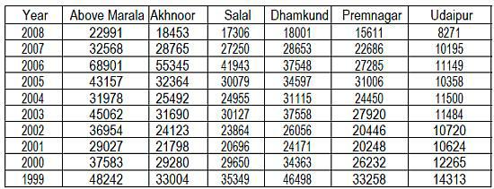
Let us start with the river Chenab by using the average flows data for the month of September over a period of ten years since 1999 at six recording points, beginning deep on the Indian side at Udaipur and moving westwards to Marala, where Chenab enters Pakistan. The flows (Discharge in Cusecs) are as follows:-


It will be seen from the above table that increase or decrease of flows at Marala is reflected in the flows at all the points on the Indian side. This shows that when Pakistan receives reduced flows, it is because of reduced flows available on the Indian side and not because of any diversion of water by India. Increased or reduced flows at Udaipur get reflected at all the subsequent points. This point is also illustrated by the following table of the annual flow in Chenab (MAF) from 1997-98 to 2008-09:-


The above table shows that decrease of flow entering Pakistan is accompanied by corresponding shortage in India. The following table illustrates flows in Jhelum (MAF) at Uri during the period 1997 to 2009:-


The annual flow in Jhelum at Uri, which was 8.29 MAF in 1997, dipped to as low as 3.07 MAF in 1999, but has subsequently recovered to register figures of 6.37 MAF in 2002, 6.31 MAF in 2005 and 5.67 MAF in 2008. The June to December flow in Jhelum at Uri shows the same pattern.
Combined annual flows (MAF) for January-December period in Indus at Nimoo and Chutak for the years 2001 to 2009 are no exception to the above trend as will be seen in the following table:-


It will be seen from the above table that the combined flows rose from 6 MAF in 2001 to 11.30 MAF in 2003, only to dip to 6.51 MAF in 2004. The flows have been steadier in recent years, registering 9.41 MAF in 2005, 10.58 MAF in 2006, 8.41 in 2007, 9.95 in 2008 and 9.93 MAF in 2009.

The data that I have provided in respect of flows in all the three Western Rivers clearly demonstrates that these flows have followed a curve moving up and down, depending upon climatic factors from year to year, rather than showing progressive decline, which would be the case if there were any truth in the allegations of India building infrastructure to progressively deprive Pakistan of its share of water.

A complaint has often been made that India has not been providing data of water flows regularly. In accordance with the Indus Waters Treaty, India and Pakistan exchange daily data on about 600 Gauge and Discharge sites on a monthly basis. India has been fulfilling its obligation in providing this data. However, if for some reason, data for particular points is not available, it is so indicated and such information, when received, is provided as supplementary data. I am told that this practice is followed by both sides. India has also supplied in the past, as a gesture of goodwill, data on floods to enable Pakistan take timely action for preventing damage as a result of floods.

One also hears the accusation that India is building hundreds of dams/ hydroelectric projects to deny Pakistan its share of water. This does not correspond to the reality on the ground. There are no quantitative limits on the hydroelectricity that India can produce using the Western Rivers. There is also no limit to the number of run-of- the river projects that India can build. However, India has so far undertaken a limited number of projects. We have provided information to Pakistan, as per the Treaty, in respect of 33 projects. Out of these, 14 are in operation, 13 are under construction, 2 are still at the proposal stage, 3 have been
dropped or deferred and work on one project stands suspended. Out of these 33 projects, as many as 20 have a capacity of 10 MW or less. Projects identified for implementation in the coming years number 22. This certainly does not make for hundreds of dams/ hydroelectric projects.

The Indus Waters Treaty requires India to provide certain specified technical information to Pakistan at least six months before the commencement of construction of river works for a hydroelectric or storage project (the period is two months for a Small Plant), in order to enable Pakistan to satisfy itself that the design of a plant conforms to the provisions of the Treaty. If Pakistan raises any objection, it has to be resolved in accordance with the provisions of the Treaty. India has been meeting its obligation to provide the specified information as necessary. In all the cases in the past, India has responded to all queries from Pakistan about such projects, even if these were not strictly in keeping with the Treaty, in order to address Pakistan's concerns. This has resulted in endless delays and cost overruns. The Tulbul Navigation project is a case in point. India provided information to Pakistan on this project as a matter of goodwill. As a further gesture of goodwill, works on the project were unilaterally stopped by India in October, 1986 and remain suspended to this day. However, infinite queries from Pakistan could amount to a virtual veto on Indian projects. This is not the intention of the Treaty in requiring India to provide information in advance of the river works. India is within its rights to proceed with the construction of a plant at the end of the period of advance notice, even if Pakistan raises objections, subject to any subsequent changes in design or any other consequences that may flow from resolution of the matter under Article IX of the Treaty.

India had communicated information concerning Baglihar project on Chenab to Pakistan as early as in 1992. Pakistan's objections were referred to a neutral expert in 2005 at the request of Pakistan. The expert upheld India's design approach and suggested only minor changes in the scope of construction. Pakistan subsequently objected to the initial filling of the Baglihar reservoir. However, this was done by us in keeping with the Treaty provisions. In fact, the Pakistan Indus Commissioner was invited to India at his request in July, 2008 to be briefed about the procedure of initial filling. The actual filling was done in August the same year within the time window specified in the Treaty.

The Kishanganga hydroelectric project on a tributary of river Jhelum has also been objected to by Pakistan, inter alia, on the ground that Pakistan has existing uses on the waters of Kishanganga (Neelum). The matter has been under discussion since 2004. However, details of the claimed existing uses are yet to be substantiated. We believe that the matter should be resolved at the Commission level, keeping in mind the provisions of the Treaty and the findings of the neutral expert in the Baglihar case. In August 2009, we also informed Pakistan that in case technical experts were unable to resolve the issue, efforts could be made to take it up at government level.

Ladies and Gentlemen, India has all along adhered to the provisions of the Indus Waters Treaty and will continue to do so. However, it is natural for questions and issues to arise in the course of implementation of any treaty. We believe that the Permanent Indus Commission is the best forum to resolve all such matters. However, for any issues that cannot be resolved in the Commission, Article IX of the Treaty provides a mechanism for settlement of differences and disputes, which can be resorted to by the aggrieved party. Since the Indus Waters Treaty provides an elaborate framework for distribution of water and resolving any questions, differences or disputes, we fail to understand attempts by some quarters in Pakistan to inflame public passions on the subject. Angry statements targeting India can neither increase the quantity of available water, nor can such statements become a substitute for the mechanism in the Treaty to resolve differences regarding its implementation.

Concerns have also been expressed about some Indian projects on Western Rivers from the environmental point of view. I would like to assure you that we have strict norms for such projects under our Environmental Protection Act and Forests Protection Act. These norms include Catchment Area Treatment Plans and Compensatory afforestation.

We have often heard the bizarre allegation that India wants to deprive Pakistan of water to dry up its canals and drains etc, which besides serving as irrigation channels, can also serve as defensive features in times of war. The Chenab Canal network is mentioned in particular in this connection. There is no truth in this allegation. It is clear from what I have mentioned so far that India has not taken any action to deprive Pakistan of its share of water and consequently to dry up its canals.

Another piece of misinformation being spread by certain circles is that a dam/hydroelectric project is being built by the Government of Afghanistan on the Kabul River with India's assistance and this would adversely affect the flows of this river to Pakistan. I would like to inform you that there is no truth in this allegation. Those who make it ought to know that a dam or hydroelectric project is not something that can be built surreptitiously. It is highly undesirable to mislead people by making such baseless allegations on issues, which are easily verifiable on the ground.

Ladies and Gentlemen, the issue of water scarcity in Pakistan cannot be analysed fully without looking at the picture in the large part of the Indus basin – around 65% - that lies in Pakistan's territory or territory controlled by Pakistan. A preponderant portion of the water of the Western Rivers flowing through Pakistan is generated in the catchment area within Pakistan or territory under Pakistan's control. This share of water is completely controlled by Pakistan. Therefore, it is difficult to understand the excessive and, in many cases, exclusive focus of the public discourse on water scarcity in Pakistan on flows from India. Moreover, as water gets increasingly scarce, the issues of water management and avoidance of wastage of water assume greater significance.

The per capita availability of water in Pakistan is reported to be around 1400 cubic meters or even less. Speaking of the availability and use of water in Pakistan, the Pakistan Water Sector Strategy issued by the Ministry of Water and Power, Government of Pakistan, in 2002 stated the following: "The Indus River and its tributaries on average bring about 152 million acre feet of water annually. This includes 143 MAF from the three Western rivers and 8.4 MAF from the Eastern Rivers. Most of the inflow, about 104 MAF, is diverted for irrigation, with 38 MAF flowing to the sea and about 10 MAF consumed by system losses." The same report stated that out of the 38 MAF flowing to the sea, 93.7% flow is during the Kharif season and for several months during winter, there is no flow to the sea. The report further stated that a part of this water could be effectively used for supplementing the irrigation water, hydropower generation and meeting the agreed environmental needs through storage in multipurpose reservoirs which could carry water over the winter season to ensure a good start to the Kharif cropping season. These statements do not signal shortage of water, but the urgent need for a closer look at the management of available water resources.

According to the report "Pakistan's Water Economy" issued by the World Bank in 2005, salinity also remains a major problem in Pakistan. According to the same report, much of the water infrastructure in Pakistan is in a state of disrepair. Water loss between canal heads and farms is reported to be significant, as high as 30%. The report further states that Pakistan has only 150 cubic meters water storage capacity per capita as against 5000 cubic meters in the US and Australia and 2200 cubic meters in China. Pakistan can store barely 30 days of water in the Indus basin. The report points out that "Relative to other arid countries, Pakistan has very little storage capacity. If no new storage is built, canal diversions will remain stagnant at about 104 MAF and the shortfall will increase by about 12% over the next decade." The Pakistan Water Strategy calculates that Pakistan needs to raise storage capacity by 18 MAF (6 MAF for replacement of storage lost to siltation and 12 MAF of new storage) by 2025 in order to meet the projected water requirements of 134 MAF. Water productivity in Pakistan also remains low. According to the above report, crop yields, both per hectare and per cubic meter of water, are much lower than international benchmarks. Improved irrigation efficiency, through techniques such as sprinkler irrigation and drip irrigation, is the answer to this problem. India has nothing to do with these issues of water management that are internal to Pakistan, but which nevertheless ought to be integral to any discourse on water scarcity. Only Pakistan can seek solutions to these matters.

Ladies and Gentlemen, the Indus Waters Treaty is an example of mutually beneficial co-operation between India and Pakistan for the last 50 years. It has withstood the test of time. Article VII of the Treaty, which deals with future co-operation, recognizes the common interest of both sides in the optimum development of the rivers and lists out the avenues of future co-operation. We need to adhere to the spirit of co-operation, inherent in the Treaty, in ensuring its implementation and to identify further areas of co-operation within its framework. Let me end with the hope that the Indus Waters Treaty, which has completed its first fifty years successfully, will continue to guide us on water sharing in the future.
 

ajtr

Tihar Jail
Banned
Joined
Oct 2, 2009
Messages
12,038
Likes
723
Annual Renewable Water Supply Per Person by Basin for 1995 and Projections for 2025
Watersheds of the World : Global Maps


Map Description

Water, used by households, agriculture, and industry, is clearly the most important good provided by freshwater systems. Humans now withdraw about one fifth of the world's rivers' base flow (the dry-weather flow or the amount of available water in rivers most of the time), but in river basins in arid or populous regions the proportion can be much higher. This has implications for the species living in or dependent on these systems, as well as for human water supplies. Between 1900 and 1995, withdrawals increased by a factor of more than six, which is greater than twice the rate of population growth (WMO 1997).

Water supplies are distributed unevenly around the world, with some areas containing abundant water and others a much more limited supply. In water basins with high water demand relative to the available runoff, water scarcity is a growing problem. Many experts, governments, and international organizations are predicting that water availability will be one of the major challenges facing human society in the 21st century and that the lack of water will be one of the key factors limiting development (WMO 1997).

These maps show water supply per person for individual river basins as of 1995 and projections for 2025. Water experts define areas where per capita water supply drops below 1,700 m3/year as experiencing "water stress"—a situation in which disruptive water shortages can frequently occur. In areas where annual water supplies drop below 1,000 m3 per person per year, the consequences can be more severe and lead to problems with food production and economic development unless the region is wealthy enough to apply new technologies for water use, conservation, or reuse. This map is based on the analysis carried out by WRI for the Pilot Analysis of Global Ecosystems: Freshwater Systems (PAGE). The first map shows that as of 1995, some 41 percent of the world's population, or 2.3 billion people, live in river basins under water stress, with per capita water supply below 1,700 m3/year. Of these, some 1.7 billion people reside in highly stressed river basins where water supply falls below 1,000 m3/year

In the second map we see water scarcity projections for 2025. The analysis shows that by 2025, assuming current consumption patterns continue, at least 3.5 billion people— or 48 percent of the world's projected population —will live in water-stressed river basins. Of these, 2.4 billion will live under high water stress conditions. This per capita water supply calculation, however, does not take into account the coping capabilities of different countries to deal with water shortages. For example, high-income countries that are water scarce may be able to cope to some degree with water shortages by investing in desalination or reclaimed wastewater. The study also discounts the use of fossil water sources because such use is unsustainable in the long term.

In the second map, a selected number of basins have been outlined. These watersheds represent basins that are in or approaching water scarcity and where the projected population for 2025 is expected to be higher than 10 million. Six of these basins including, the Volta, Nile, Tigris and Euphrates, Narmada, and the Colorado River basin in the United States, will go from having more than 1,700 m3 to less than 1,700 m3 of water per capita per year. Another 29 basins will descend further into scarcity by 2025, including the Jubba, Godavari, Indus, Tapti, Syr Darya, Orange, Limpopo, Huang He, Seine, Balsas, and the Rio Grande.

Mapping Details

These maps were developed by combining a global population database for 1995 that uses census data for over 120,000 administrative units (CIESIN et al. 2000) and a global runoff database developed by the University of New Hampshire and the WMO/Global Runoff Data Centre (Fekete et al. 1999). The runoff database combines observed discharge data from monitoring stations with a water balance model driven by climate variables such as temperature and precipitation combined with variables on land cover, and soil information. For those regions where discharged data were available, the modeled runoff was adjusted to match the observed values; for regions with no observed data, the modeled estimates of runoff were used. The 2025 estimates are considered conservative because they are based on the United Nations' low-range projections for population growth, which has population peaking at 7.2 billion in 2025. In addition, a slight mismatch between the water runoff and population data sets leaves 4 percent of the global population unaccounted for in this analysis.

Map Projection

Geographic

Sources

Revenga, C., J. Brunner, N. Henninger, K. Kassem, and R. Payne. 2000. Pilot Analysis of Global Ecosystems: Freshwater Systems. Washington DC: World Resources Institute. Based on CIESIN (Center for International Earth Science Information Network), International Food Policy Research Institute, and World Resources Institute. 2000. Gridded Population of the World, Version 2. Palisades, New York: CIESIN and Columbia University, and Fekete, B., C. J. Vörösmarty, and W. Grabs. 1999. Global, Composite Runoff Fields Based on Observed River Discharge and Simulated Water Balance. World Meteorological Organization Global Runoff Data Center Report No. 22. Koblenz, Germany: WMO-GRDC.

WMO (World Meteorological Organization). 1997. Comprehensive Assessment of the Freshwater Resources of the World. Stockholm, Sweden: WMO and Stockholm Environment Institute.
chaanakya said:
There are three river basins of India figuring in the list-Narmada,Tapti and Godavari as likely to become water stressed basis Indus is also in the list which will go into water scarcity by 2025. If Paistan continues with its obsession with India it would overlook its problem of water management , efficiency and productivity per capita water use and land use thereby leading ot all sorts of problem. Atlas clearly indicates that Inuds is the only major source of water ( almost double of Nile discharge) while rest of Pakistan is arid land. Its continued obsession will propel the whole country into arid zone.Pakistan is acting like ostrich. That land is not new to the phenomenon of Lost civilisation. It has happened in ancient past and could happen again..
 
Last edited:

nandu

Senior Member
Joined
Oct 5, 2009
Messages
1,913
Likes
163
River water sharing: India-Pak fury ends

New Delhi, May 15: India-Pakistan talks on the sharing of river water buried up the tantrums as the experts from both nations have agreed on installing telemetry systems on the rivers which originate from Himachal Pradesh and Kashmir.

The officials have also decided to enable watershed management to make sure they sustained and increased water flow from the rivers.


The executives from two nations came to conclusion during the meeting held in New Delhi from May 5 to May 7, under the advocacy of Centre for Dialogue and Reconciliation (CDR).

If the plans work out, the water-conflict between two neighboring countries would be resolved, think the officials. The telemetry systems would make sure the transparency of the quantum of water, which will travel from India to Pakistan. With water shed management, the ecology of the place from where the river originate, will improve. It will provide a better flow of water in the rivers like Jehlum and Chenab.

The group of executives included Gen V P Malik (the former Indian Army Chief), Rajmohan Gandhi (grandson of Mahatma Gandhi), Mani Shankar Aiyar, Najmuddin Shaikh, Gen Dipankar Bannerjee (former Indian Army Chief General), V Balachandran, Bushra Gohar, Amitabh Mattoo, Neeraja Chowdhary, Salman Haider, and Humayun Khan among others.

http://news.oneindia.in/2010/05/15/india-pak-talk-sharing-river-water.html
 

ajtr

Tihar Jail
Banned
Joined
Oct 2, 2009
Messages
12,038
Likes
723
Time bombs ticking


Sunday, May 16, 2010
Ghazi Salahuddin

We have this huge lake created in the Hunza valley by a massive landslide that took place in January. Now, a potentially devastating disaster is almost waiting to happen. This has been likened to a water bomb and it is ticking. Already, a lot of damage has been done. A grim sense of urgency has built up in recent days and emergency measures have been undertaken. What could happen when the artificial Hunza lake, swelling by the hour, bursts its banks?

In this case, fortunately, we are confronted by a challenge that is starkly visible and has immediate consequences of a tangible nature. We will at best be tested by our ability to take the right steps and by our readiness for dealing with the vast dislocations that are likely. But what about other disasters which are in the making, with outcomes that may be even more catastrophic?

The idea here is of a time bomb. The Hunza lake was a time bomb the moment it came into being. This catch phrase, of a time bomb, is repeatedly used. On Friday, Shafqat Mahmood's column on this page was titled: "The UN report is a time bomb". Or they say that time is running out. Time has been running out for us in many different contexts. There is always something nasty around the corner. Like the probability of a confrontation between the higher judiciary and the executive.

On Saturday, yesterday, the Hunza lake story was not as prominent in our newspapers as the headline that the Supreme Court has summoned Federal Minister for Law Babar Awan on May 25. He has been summoned to brief the court about steps so far taken for the implementation of the NRO verdict. Panelists on our television talk shows have expressed some caustic comments on what could happen on May 25.

But the analogy that I want to draw with reference to the Attaabad water bomb is not related to any particular event or development. It has vastly more sinister dimensions in terms of the damage it would cause to the nation. And I have in mind the population time bomb. It is ticking in every nook and cranny of this country. Again, time is fast running out.

What I am not doing here is to dabble in statistics, though the figures that relate to our population time bomb would be enough to inundate us with horror and even disbelief. Some essential facts should suffice. We are already the sixth largest population in the world, with an exceptionally large ratio of young people. If the existing trends continue, we could, in a few decades, become the fifth and then the fourth largest country in the world, overtaking Brazil and Indonesia.

Incidentally, I owe the focus of this column to a diplomatic reception in Karachi earlier in the week where a rather agonised concern was voiced over our demographic situation. After all, if other countries of the world have to bear some burden of the rise of religious extremism and Talibanisation in Pakistan, they should also be wary of the global impact of an explosion of the population bomb in a country like Pakistan.

We do know that people, in essence, can be a great resource when they are educated and skilled and when they have opportunities to lead productive and creative lives. A high percentage of young people becomes an asset in this situation. Ageing populations in a number of developed countries have to be supplemented with immigrant workers. In our case, the overall situation is so dismal, so depressing that even thinking about it would leave you in acute depression.

Now, when you talk about a time bomb, the impression is that disaster may surface after some time. What the rising tide of population, swelling every minute, has done to us by now is very much in evidence. What it can be like in coming years may be judged by the few stories of the misery of the ordinary people that the media is able to cover. This spectacle of deprivation is before our eyes and every day presents its own tally of tragedies.

As I write this, I have before me this front-page story: "Man commits self-immolation in Lahore". There is a photograph in another newspaper of a group of small children sitting under a banner in Bahawalpur that announces "Children for sale". For those who do not read newspapers and avoid watching news bulletins on television, a stroll in any crowded place would be sufficient to project the misery in which this society is beginning to be submerged.

So what have our rulers, present and the past, done about it? One measure of this, obviously, would be to look at the state of education in our country. Again, it is something that we need not explore in any statistical analyses. Nor should there be any need to look at how our material resources, mostly borrowed from international agencies, are allocated to different sectors, irrespective of their leakages.

By the way, the issue of the fake degrees of our elected representatives, the ones who profess to be arbiters of the nation's destiny, is a good illustration of what education means to us. There was this report in this newspaper, quoting a retired senior official of the Election Commission, that "almost 148 MNAs and MPAs are feared to be holding fake degrees".

Yes, setting educational qualifications for members of national and provincial assemblies did not make any political sense. However, the point here is that those who sought fake degrees were deliberately cheating and lying. One can say that the whole edifice of our governance is without any moral foundation. We can see it crumbling. It is another time bomb and we can also expect some kind of an explosion in this realm.

As I have suggested, Pakistan is plagued with many serious problems and its unplanned, growing population is becoming the seed of a total disaster. It is just not the issue of education or health or energy or housing or employment. The human dimension of it, in terms of the aspirations and longings of the people, is unimaginably portentous. Surely, the time is running out.

Meanwhile, the present rulers, some of them with their fake degrees, are busy in their familiar antics. For them, it is business as usual. And where is this taking us? What is the sense of direction of this government? On Wednesday, a respected leader of the ruling Pakistan People's Party, Zafar Ali Shah, surprised his colleagues by criticising his own party's leadership in the National Assembly. He accused the party of turning Pakistan into a 'banana republic'. Who knows, someone in the government may even take this as a compliment.
 

ajtr

Tihar Jail
Banned
Joined
Oct 2, 2009
Messages
12,038
Likes
723
X-posting

Work apace on 330 MW K'ganga project​


Srinagar, May 15: Rejecting Pakistan's claims that Kishenganga power project in North Kashmir was violating the Indus Water Treaty (IWT), the State government Saturday said the work on the 330-MW project would continue as it did not violate IWT provisions.


The government also said that it was seriously pursing to seek transfer of Dulhasti and Salal power project to the State to overcome power crisis in Jammu and Kashmir.

"The work on Kishenganga power project is going on under the provisions of IWT," Principal Secretary Power, B R Sharma told Rising Kashmir.

He said there has been no violation of IWT and the work on the project will not be stopped. "The Indian Commissioner for IWT has made it clear that the work on Kishengana project by NHPC was being carried out within the provisions of IWT."

Sources said the Government of India had sought a detailed report from NHPC, Commissioner IWT and JK government about the present status of Kishenganga project. "GoI sought the report after Pakistan threatened to move the International Court of Arbitration to stop the work on the power project. After the report cleared that Kishenganga project did not violate IWT provisions, the GoI asked the constructing agency (NHPC) to go ahead with the project," they said.

As per IWT, brokered by World Bank in 1960, Pakistan was empowered to monitor the usage of three rivers — Jhelum, Chenab and Indus — that flow from JK to Pakistan. The treaty also wrested full powers to India to use three Punjab rivers — Ravi, Sutlej and Bias.

Sharma said the State government was strongly following the recommendations of Rangarajan committee constituted by Prime Minister Mahmohan Singh. "The committee has strongly recommended that Dulhasti and Salal power projects be returned to Jammu and Kashmir," he said.

In the first phase, Sharma said, the government will try to get back 390 MW Dulhasti project on river Chenab in Kisthwar district. "Later, we will try to seek the return of Salal also," he said.

He said Dulhasti, if returned to State, will help the government in overcoming power crisis in Jammu and Kashmir.


Theo_Fidel said:
WRT to Kishan Ganga, this has been posted many times before but I'll do it again. Esp. as there appear to be many new posters who wonder if TSP has a case on Kishan Ganga.

When the Indus Treaty was written it was specifically understood that the Jhelum was a special case with many of its tributaries at very different elevations.

The Indian drafters therefore specifically included a special clause to cover this eventuality. They must have know that they would never live to see these projects. Yet showed the foresight to leave it for future generations. Sometimes credit should be given to the Government Babu's.

See clause 3 below. There is no squirming room for TSP.

15 . Subject to the provisions of Paragraph 17, the work s
connected with a Plant shall be so operated that (a) th e
volume of water received in the river upstream of th e
Plant, during any period of seven consecutive days, shal l
be delivered into the river below the Plant during the sam e
seven-day period, and (b) in any one period of 24 hour s
within that seven-day period, the volume delivered int o
the river below the Plant shall be not less than 30%, and
not more than 130%, of the volume received in the rive r
above the Plant during the same 24-hour period : Provided
however that :

(i) where a Plant is located at a site on the Chenab
Main below Ramban, the volume of water receive d
in the river upstream of the Plant in any one perio d
of 24 hours shall be delivered into the river belo w
the Plant within the same period of 24 hours ;

(ii) where a Plant is located at a site on the Chena b
Main above Ramban, the volume of water delivere d
into the river below the Plant in any one period o f
24 hours shall not be less than 50% and not mor e
than 130%, of the volume received above the Plant
during the same 24-hour period ; and

(iii) where a Plant is located on a Tributary of Th e
Jhelum on which Pakistan has any Agricultura l
Use or hydro-electric use, the water released belo w
the Plant may be delivered, if necessary, into an -
other Tributary
but only to the extent that the then
existing Agricultural Use or hydro-electric use b y
Pakistan on the former Tributary would not b e
adversely affected .
 
Last edited:

ajtr

Tihar Jail
Banned
Joined
Oct 2, 2009
Messages
12,038
Likes
723
River water sharing: India-Pak fury ends

New Delhi, May 15: India-Pakistan talks on the sharing of river water buried up the tantrums as the experts from both nations have agreed on installing telemetry systems on the rivers which originate from Himachal Pradesh and Kashmir.

The officials have also decided to enable watershed management to make sure they sustained and increased water flow from the rivers.


The executives from two nations came to conclusion during the meeting held in New Delhi from May 5 to May 7, under the advocacy of Centre for Dialogue and Reconciliation (CDR).

If the plans work out, the water-conflict between two neighboring countries would be resolved, think the officials. The telemetry systems would make sure the transparency of the quantum of water, which will travel from India to Pakistan. With water shed management, the ecology of the place from where the river originate, will improve. It will provide a better flow of water in the rivers like Jehlum and Chenab.

The group of executives included Gen V P Malik (the former Indian Army Chief), Rajmohan Gandhi (grandson of Mahatma Gandhi), Mani Shankar Aiyar, Najmuddin Shaikh, Gen Dipankar Bannerjee (former Indian Army Chief General), V Balachandran, Bushra Gohar, Amitabh Mattoo, Neeraja Chowdhary, Salman Haider, and Humayun Khan among others.

http://news.oneindia.in/2010/05/15/india-pak-talk-sharing-river-water.html
this is the cave in by indian govt. As S.Sridhar at BR says while interpreting it as following...
both telemetry and joint watershed management are unacceptable.

The basic approach of Pakistan is to intrude into the rights of the upper riparian. Pakistan has successfully managed to convince everyone that it is paranoid about India and somehow this justified paranoia confers legitimacy on it to demand bizarre things from India even to the extent of violating India's sovereignty or legal Treaty requirements. Indian generosity is then expected or even demanded to resolve the issue.

The IWT lays down what data can be demanded and at what frequency. India should simply stick to that. Article VII (Future Cooperation) states:

(a) Each Party, to the extent it considers practicable and on agreement by the other Party to pay the costs to be incurred, will, at the request of the other Party, set up or install such hydrologic observation stations within the drainage basins of the Rivers, and set up or install such meteorological observation stations relating thereto and carry out such observations there at, as may be requested, and will supply the data so obtained.
India should simply reject the telemetry request as impracticable. One simple reason is that they have not been found to work in Pakistan itself. It is tough luck for Pakistan if it doesn't trust Indian data.

Watershed is the drainage area (or catchment area) for a river. Joint watershed management completely intrudes into Indian sovereignty. No upper riparian has ever been subjected to such a bizarre demand. This speaks volumes for the audacity of Pakistan, which is anyway legendary. Besides, the Indus originates near Kailash-Manasarovar in tibet ,china.

The request for telemetry comes from a distrust of data supplied by India. The request for telemetry data is to bypass Indian compilation of data and take it directly from the RIM and other stations bypassing India. How India collects data that needs to be supplied to Pakistan is India's botheration. Ultimately, it is India that must supply data within the parameters of the IWT.

It should be repeatedly told to pakistani people that Number 1 reason (apart from engineering issues of badly constructed canals and outdated agricultural practices, which will take years to rectify), is water stealing by Pakistani army & other Punjab elites and inequitable distribution of water between the provinces. They blame on India stealing water is directly because of this. So obviously, reducing tension & blame on India stealing water can be done only by addressing the "root cause". Which would be inequitable distribution of water between the provinces. India should show every initiative and enthusiasm to help. We can share our experiences with water distribution, and use our good offices to arbitrate.

Providing telemetry & joint watershed management is not solving the problem at all and it serves only to draw us into an irrelevant discussion!! the actual problem, which would have 3 components: Engineering issue of canals, agricultural issue of agricultural practices, Political and criminal issue of inter-provincial water sharing.

India should be proactive and offer to help in all three, instead of being on the defensive to deny a cooked up problem.

In fact, this should be another litmus test of Pakistani sincerity towards solving its water problem: Identifying the actual issues causing the problem with proper data, facts, figures and rationalization. After that, india can see what india can do to help. Else india-pak will go nowhere.
 

ajtr

Tihar Jail
Banned
Joined
Oct 2, 2009
Messages
12,038
Likes
723
Building on a Treaty


A water treaty has been keeping India and Pakistan on some level ground since 1960, at least as far as the water systems are concerned

In 1960, India and Pakistan signed the Indus Water Treaty, with the World Bank's mediation, to end controversies relating to water sharing between the 2 countries. Although geography and terrain makes it difficult to harness the Indus Water on the Indian side of Jammu and Kashmir, Pakistan frequently made an issue over small scale use of waters of the tributaries as per the treaty. The Treaty proved its effectiveness as it survived recurrent wars and recrimination from the Pakistani side.
It also helped set up an Indus Commission, headed by empowered engineers, for conflict management and as a resolution mechanism. There was only one occasion where Pakistan referred the matter to a neutral expert for a court of arbitration over Baghlihar Dam. The expert cleared the project with minor technical modifications on the height two years ago. Pakistan raised propaganda frenzy over Baghlihar but the neutral expert ruling rubbished the objections.
The Treaty allocated 3 Western rivers, namely Indus, Jhelum and Chenab wholly to Pakistan, which together account for an average water flow of 135 million acre feet. Out of this, India is allowed to irrigate 1.3 million acres and 3.60 million acre feet of water for storage projects, including for conservation and flood control etc. Despite these allocations, India could only use waters to irrigate less than 0.8 million acres as against 1.3 million acres allowed. Under the treaty, India renounced its right to block or divert the flows of the Western rivers and agreed to confine itself to run-off-the-river hydro electric projects and drawing of irrigation water for specific acreage of farmland. Even that was not fully utilised as mentioned above.
With regard to 3 Eastern rivers, namely Sutlej, Beas and Ravi, the entire flows of these rivers were allocated to India. India had provided £ 62 million to Pakistan under the treaty to compensate for construction of new canals in Pakistan after being allowed unrestricted use of waters from Eastern rivers. The total flow of these 3 rivers is 33 million acre feet only and India has not been able to harness the entire potential leaving 3 million acre feet of water flowing into Pakistan.
As the above shows, out of the combined net flow of waters of these six rivers, Pakistan got 80 % of the overall flows and India 20%.
The Treaty provided for exchange of data on flow of water, and proposed hydro power projects as allowed. As the treaty mandates broad Pakistan approval for Indian works on the Western rivers, they used the opportunity to raise number of objections leading to considerable delays in implementation of the projects. The Sallal, Yuri, Dul Hasti and Baghlihar all run-off-river hydro-power schemes without any storage requirements were delayed with Pakistan questioning every aspect of the schemes like technical specifications, data on water flows etc.
In all the cases of objections, the Pakistani argument has been that sudden pondage and release of such waters could be used by India to dry up lower course of Chenab or cause floods that would render Pakistan economically and strategically vulnerable. The argument has no basis and those who know the geography and terrain of Valley would know that such a measure would damage India before it causes any hardship to Pakistan which is 110 Kms down the river course.

Disputes over water sharing among various provinces was a fact of life in united India much before 1947. In-flows of waters are declining over a long period as they depend not just on rain fall and snow melt, but also on the health of tributaries, streams, nullahs as well as ground water, soil and water management practices.
The latest objections of Pakistan relate to the Kishanganga Project on a tributary of Jhelum which is also a run-off-the-river hydro electric project. The project involves channelling of waters of the Kishanganga tributary, which is known in Pakistan as Neelam, to feed the hydro-power project and the waters later re-join the Jhelum river in Pakistan. Total quantum of flow of water will not be affected. This is as permissible by the treaty and the project was initially proposed in the period during 1991-93. However, Pak-sponsored terrorism prevented its construction. It was proposed again in 2003 and again delayed due to terrorist activities. Pakistan was notified yet again last year about the taking up the project. Pakistan, therefore, is hurriedly putting up, with Chinese assistance, its own power project on the Neelam, north of Muzafferabad, to pre-empt the Kishanganga Project.
Pakistani objections to Kishanganga hydro-power project are based on claims that there will be 27% of water shortage in the tributary in the Neelam valley affecting irrigational use. Indian side provided data showing that flow reductions in the tributary during specific periods will only be 15-16% and this would not affect current pattern of use in the valley. Pakistan also claimed that 1.3 lakh hectares are under irrigation under the tributary, but was not able to show it when Indian experts visited the area, three times in 1991, 1996 and 2008. As Pakistan did not have a strong case to force the halting of Kishanganga project, it is creating a frenzy of orchestrated propaganda involving even terrorist groups with threats of launching suicide bombings and even nuclear attacks on Indian projects. Instead, it serves them better if they provide required data on their claims to Indian side for mutually beneficial negotiations or refer to a neutral expert for a ruling if they strongly feel of having a reasonable case.
Many of the problems that Pakistan is attributing to alleged water diversions by India are actually rooted in their domestic politics. Although, India had provided £ 62 million to Pakistan for building new canals in Pakistan for better water management, Pakistan has not constructed any such water management schemes for storage and regulated utilisation of water.
Foreign Minister Shah Mehmood Qureshi said in a statement last month that while people say that all of Pakistan's problems are as a result of their neighbouring country, it is important for people to look within themselves. He said that the dispute with India was not new, and that the Sindh Water Treaty had come into existence to resolve the water issues and act as a mechanism for talks. He said that the Sindh Water platform had been used in the past and would continue to be used in the future. Furthermore, he said that 34 million acre feet of water was being wasted in Pakistan, and that no one was concerned.

Sam Burgess is an senior fellow at the Asian Foundation
 

ajtr

Tihar Jail
Banned
Joined
Oct 2, 2009
Messages
12,038
Likes
723
Sherry rehman's interview in Rediff
SSridhar said:
What are the issues?

First, we have concerns over water. Pakistan is water-stressed and there has to be clarity on how to manage within the Indus Waters Treaty, how to manage flows of storage. There is a fair amount of ignorance on this issue on both sides {Ahh. . .please elaborate the ignorance on the Indian side} of the border. In Pakistan, we are losing as much as 30 per cent of our water. Moreover, when matters come to a head (because of disputes with India) and reach the international arbiter, we lose an entire sowing season, {This is a big, big lie. How many times have matter reached international arbitration since 1960 when IWT was signed ? How many times have international arbitrators found fault with India and restored order and how many sowing seasons have been missed because of this on the Pakistani side ?.Besides, she is trying to give an impression that India violates IWT repeatedly and international arbitration has to be resorted to rectify the violation !} destituting a large number of people. This is one concern that should definitely be on the table.

Kashmir and terrorism are obvious issues. The latter is not a concern for just India, but also for us. We are seeking to eliminate terrorists that have taken refuge on the open border between Pakistan and Afghanistan. We are, in fact, experiencing many Mumbais everyday.
**comments in blue are by ssridhar
 

ajtr

Tihar Jail
Banned
Joined
Oct 2, 2009
Messages
12,038
Likes
723
Kaikobad is out, old team stays to fight Kishanganga

Sunday, May 09, 2010
Jang group has another feather in cap

By Khalid Mustafa

ISLAMABAD: Representatives of the Pakistan Army, ISI and top officials of Ministry of Water and Power shot down the appointment of little known Professor Kaiyan Homi Kaikobad as head of the legal team of Pakistan in the International Court of Justice (ICJ) against India on Kishanganga hydropower project, it was learnt.

It was decided that the previous Pakistan team headed by Professor James Crawford that had fought the legal battle against India on Baglihar Hydropower project will fight the case on Kishanganga hydropower project.

The said decision has reportedly been taken in the two-day meeting which ended on Friday. Minister for Water and Power Raja Pervez Ashraf chaired the meeting while Secretary Water and Power Shahid Rafi, Special Assistant to Prime Minister on Water issues Kamal Majidullah, Pakistan Commissioner of Indus Water Syed Jamaat Ali Shah, Attorney General Justice (R) Maulvi Anwar-ul-Haq and concerned officials of Ministry of Foreign Affairs, Law and Justice, Nespak, Pakistan Army and ISI attended the meeting and discussed the strategy on legal battle in the ICJ.

It is pertinent to mention that the issue of the unqualified Kaikobad's appointment was vigorously agitated in the highly popular programme of Geo News "Kehnay May Kya Hurj Hai" hosted by Mohammad Malick.

The issue was also raised repeatedly in The News and this latest righting of a serious wrong is another feather in the cap for Jang Group which is striving for ensuring clean transparent governance by the government.

Kamal Majidullah was said to be the strongest proponent of Kaikobad leading the legal charge. Kaikobad, however, has already been appointed as a legal consultant on water to Pakistan government at the hourly charge of 200 pounds sterling. It was argued that Pakistan cannot afford to try a new team headed by an unproven new man like Kaikobad who has not fought a single case in the international arbitration court while James Crawford is a well known expert in international water law.

Sources revealed that Kamal Majidullah, reputed close friend of President Asif Ali Zardari, who had been the driving force behind Kaikobad's inexplicable catapulting, was virtually isolated in the meeting and his viewpoint was not entertained seriously. It was indeed a bad day for the man.

Now under the new scenario, Mahmud Ali Durrani, former ambassador of Pakistan to the US, will be replaced with Husain Haqqani. However, rest of the whole team may be the same with some changes.

Pakistan on April 19 has forwarded two names to India for the constitution of the arbitration court. India would also propose their names and then both the countries would agree upon on the name of chief of the arbitration court. The constitution of the court will take place within another five to eight months.

Some independent experts are of the view that Pakistan has delayed to move the international court as India has already managed to substantially construct Kishanganga project. According to some reports, India has completed 80 per cent construction on the project which was initiated by mid 1990s.

However, the physical work on Neelum-Jhelum hydropower project was initiated in 2007 and according to Wapda, about 15 per cent work has been completed. In case India completes its project earlier than the completion of Neelum-Jhelum, then it will clinch the water priority right of Neelum River.

This will have adverse impact of 30 per cent reduction in water flows(At least pakistani papers must quote correct figure...some say 27% and others say 20 and the one report actually qutoe as 15% based on actual calculations) which resultantly make the $2.5 billion Neelum-Jhelum project not feasible as the power generation of 969 MW will not be realised in the wake of reduction in water flows.
 
Last edited:

ajtr

Tihar Jail
Banned
Joined
Oct 2, 2009
Messages
12,038
Likes
723
As per the above report in thenews on appointment representative on kishanganga case some might like to think that if India abides by the treaty provisions, Pakistan may not raise dispute. That is only wishful thinking. Pakistan has raised objections on each and every project of India and that includes Eastern Rivers as well to which India has exclusive rights.

There are set procedures laid down in IWT by which differences and disputes get addressed. Court of Arbitration is provided under IWT under Article IX(5) read with Annexure G.


Article IX(2)(b) reads that if a difference does not come within para (2)(a) or if NE informs the Indus commission in accordance with para 7 of Annexure F that the difference should be treated as dispute , a dispute shall deemed to have arisen to be settled as per para (3)(4)(5/ of Article IX....Provided further that any difference can be dealt with in any other way agreed upon by the Commission besides by NE and Court of Arbitration(COA).
(3) if a dispute has arisen the commission shall report the fact , at the request of either commissioner, to the two govt. as early as practicable with the following details:points on which commission is in agreement, the disputes, views of the each commissioner and his reasons.
(4) Either Govt , upon receipt of the report or if it feels report being unduly delayed, invite the other govt to settle the dispute by agreement.It will communicate names of negotiators and readiness to meet negotiators of the other govt at time and place indicated by the other govt and also enlist services of one or two mediators as may be acceptable.
(5)COA would be setup in the manner provided in Annexure G, upon mutual agreement by both parties to do so;at the request of either party , after negotiations have begun, if it is of the opinion that negotiations or mediators are unlikely to resolve the dispute; or at the request of either party after the expiry of one month of receipt of invitation by the other govt if that party comes to the conclusion that the other govt is unduly delaying the negotiation.


So if Pakistan thinks that there is a dispute then there is a dispute within the meaning of IWT. I am quite sure that Pakistan would not go to NE , having tasted failure there, and would try COA route. Now one may notice that if one party is determined to raise dispute then there are set procedures and requires strict adherence to it before mechanism gets invoked.

Despite all the rhetoric by Pakistan in public it is quietly following that procedure and are fully aware that it would take at least 8 months before COA gets constituted.

One redeeming point in IWT is that it does not have provision for status quo though one party may decide to stop the work as done by India in case of Tulbul Navigation project . On the Kishenganga project. there are many under a wrong impression that India must complete its works before the Pakistanis. That is completely wrong. The IWT is very clear. It says that any existing Pakistani hydroelectric project should not be adversely affected.

Pakistan did not have an 'existing' project when India made its intentions known about the Kishenganga project. Secondly, even if there is such a project, India, must ensure that the Pakistani project is not adversely affected;if existing means at the time of starting the project and not at the time of completion of the priject. Indian experts had visited the Neelum valley to ascertain agricultural usage by PK on invitation of PPIC and they had failed to substantiate their claim of agricultural usage.This was after preliminary work had started on KG . Pakistan has to prove that it had pre-existing usage , power , irrigation etc. Onus is on Pakistan. There is none as proved by report by Sam Burgess, "Building on Treaty",except may be for some irrigation works in Neelum Valley claimed by Pakistan and yet to be shown on the ground to IN experts. Kisheganga Dam is going to flood Gurez valley which may be a boon for IN as it is a major staging area for infiltration.

One more point is diversion is permitted on Jhelum subject to the conditions preceding and succeeding the highlighted part.

But such is the nature of dispute settlement mechanism that Pakistan would raise it if it wants to and India has to go by it if it does not abrogate the treaty, which is not needed as India may continue to work on the project.

Why Pakistan feels confident that it would have a better outcome in COA.

COA will consist of two arbitrators each by either party.
Three umpires 1. Person qualified by status and reputation to be chairman, 2. highly qualified engineers and 3. person well versed i international law. Chairman shall be from 1 above. Parties shall nominate and maintain a standing panel consisting of four umpires in each of the category. by mutual agreement and consent of umpires being nominated and in the order in which they would be invited to serve on COA ( by mutual agreement or by lots)If panel is not nominated by procedures underlined in Ann G (some procedures not mentioned here, please refer to Ann G) then under para 7(b) remaining vacancies in umpires will be filled up by lot from
a. for Chairman:- Secy Gen UN and President WB
b.for engineers:president MIT and Rector Imperial College of Sc & Tech London.
c.for legal members:-Chief Justice of USA and Lord Chief Justice of England

If USA is in Pakistan favour it would have 4 members in its favour. Decisions are by majority present and voting with each having one vote and chairman casting vote. This is just a conjecture and I have no reason to cast doubt on these eminent persons integrity.But International Diplomacy is such that one needs to be wary of pitfalls. Pakistan would certainly delay and not agree to anything reasonable under the sun and see that Umpires are nominated from this list. Paranoia may be.Hopefully IN continues its work apace despite COA proceedings and completes the work for it to become fait accompli.

thanks chanakaya for above comments with little editing from me...
 
Last edited:

ajtr

Tihar Jail
Banned
Joined
Oct 2, 2009
Messages
12,038
Likes
723
Surging water destroys banks of Atta Abad Lake

Updated at: 2140 PST, Monday, May 17, 2010 ShareThis story
GILGIT-BALTISTAN: The deadline for the evacuation of residents of low-lying areas to safer places has been extended for one more day.

The water level at landslide-triggered lake in Atta Abad area of Hunza has risen to the level of 358 feet due to rain and falling of a glacier.

The people residing in the danger zone are being stressed upon to evacuate to safer places, as the lake has risen to a threatening level, owing to rapid meltdown of glacier during the last two days.

According to Director General NDMA and Interior Secretary Asif Bilal Lodhi, the water level falling into the lake has been increased from 2200 cusecs to 2500 cusecs daily whereas out flow has been reached to 100 cusecs from 84 cusecs. The number of relief camps established between Hunza and Gilgit has also been increased from 18 to 39 keeping in view the situation.

Deputy Commissioner Gilgit told Geo News that arrangements for water and power supply to 195 camps in district Gilgit have been completed and the government has extended the evacuation deadline till tomorrow.

The boat service for Hunza-Atta Abad lake was suspended, as the water has reached the spillway built by Frontier Works Organization (FWO), for safe outflow of water from the reservoir.

Suspension of the service will also disrupt the land communication between middle and upper Hunza.

According to the district administration, the lake is spread over 16 kilometer of land and the water level is rising at the rate of three feet per 24 hours.

Surging water of Atta Abad Lake has started to eat away its banks and evacuation of residents of the area has set in motion.
 

ajtr

Tihar Jail
Banned
Joined
Oct 2, 2009
Messages
12,038
Likes
723
The current move by the pakistanis seems aimed at two fronts:
1. The age old - get a stay order from a court. In the interim, build their own Neelum-Jhelum project.
2. Give an impression to the common citizens in Pakistan that the Army and the ISI is looking after the interests of Pakistan.
The idea being that any concession that the arbitration court will grant to Pakistan will be hailed as a major victory for Pakistan and the Army there will be at the forefront to accept credit.

On both counts this is wishful thinking. India has already delayed the Kishenganga-Tulbul Navigation-Wullar Barrage project for many years when the paksitanis were showing India a rudimentary tunnel at Nauseri as proof that they were working on the Neelum Jhelum Project. Fact was that they neither have the money nor the expertise to complete such a project of this magnitude. Recently they had to bring in chinese engineers to help build the tunnel linking Nauseri to Zaminabad to bypass the Kishenganga (Neelum) water into the Jhelum.


**courtesy gagan....
 

ajtr

Tihar Jail
Banned
Joined
Oct 2, 2009
Messages
12,038
Likes
723
On the side note.....

The huge lake on the Hunza river as a result of a landslide is now available in High Res on Google Earth. The picture is dated March 19, 2010, when the lake is about 10.9Kms long. The town of Hullehgush along with about 15 Kms of Karakoram Highway is deep underwater.

Landslide:


The same area in 2006: There is a small area of low resolution in the middle of this pic.


The lake in March 2010: Notice that the Karakoram Highway is deep underwater.


The same area in 2006


**courtesy gagan
 

ajtr

Tihar Jail
Banned
Joined
Oct 2, 2009
Messages
12,038
Likes
723
SUMMARY OF LOSSES / DAMAGES DUE TO LAND SILDE / MOVEMENT OF TERRAIN, VILLAGE ATTA ABAD/KOHISTAN - PERIOD COVERED UPTO 14 MAR 2010

 
Last edited:

ajtr

Tihar Jail
Banned
Joined
Oct 2, 2009
Messages
12,038
Likes
723
Spilling over


Thursday, May 20, 2010
An unforgiving geology in Gilgit-Baltistan has created a problem that has impacted on the lives of the people of Hunza like no other in recent years. They were little affected by the earthquake of 2005, but the Atta Abad Lake caused by a massive landslide that dammed the river and cut the Karakoram Highway has brought destruction and disruption on a scale similar to that of a seismic event. Fortunately, loss of life thus far has been relatively low, but if the artificial dam breaks that situation could change rapidly as a wall of water would surge down riverbeds that are currently almost dry. Already, tens of thousands have been evacuated, camps prepared for affectees, food stockpiled and emergency transport laid on. A warning system has been set up so that downstream communities can quickly get to safety in the event of a catastrophic collapse of the dam and the world's media, sensing a big and dramatic story, is sitting in the wings. There has been some fanciful speculation around the management of this natural disaster, including the suggestion that the dam and the lake be used as an energy generator. (Energy-generating dams have to be carefully built, an uncompacted mass of mud and rubble formed by a natural event does not constitute a basis for a working dam.) Blasting the dam was never a reasonable solution as it would create an uncontrolled breach; and the construction of spillways to manage the outfall when the lake rises to the lip of the channels is the only solution that has a chance of success.

As with all natural disasters there have been complaints that the army, the government and the Frontier Works Organisation (FWO) have all failed in part to fulfil their duties and obligations. Doubtless any post-mortem will show that there were 'holes' in the thinking, methodology and application of all the agencies involved. This does not mean that they got everything wrong, just that they may not have got everything right. There still could be a yet greater disaster if the spillways are not equal to the task of managing the outflow, their walls erode under the pressure and there is a progressive collapse -- it is difficult to predict which way things will go. For the people of Hunza-Nagar there is already the loss of income caused by the problems of crop extraction as well as seeing their homes and civic infrastructure either washed away or damaged beyond repair – and an uncertain future. For now, the imperative is to protect life and if possible prevent a collapse of the dam by canalising the outflow – and our armchair strategists and instant disaster management experts need to be a little more circumspect in assessments that few of them are qualified to make.
 

ajtr

Tihar Jail
Banned
Joined
Oct 2, 2009
Messages
12,038
Likes
723
Karakoram traders flee border post

By Syed Fazl-e-Haider


KARACHI, Pakistan - The damage to Pakistan's already fragile economy caused by a landslide blockage of the Karakoram Highway (KKH), the country's key landlink with China, is mounting, with the evacuation this week of Sost, the land port on the border between the two countries.

Continuing heavy rains in the mountainous Gilgit-Baltistan area and melt-waters from surrounding glaciers have brought fresh landslides and further raised the level of a vast lake - now 16 kilometers long - that has built up behind the initial blockage at Attaabad, about 750 kilometers north of Islamabad. The level of the lake at Attaabad has reached 97 meters, according to Dawn newspaper last week, citing the National Disaster Management

Authority, and experts fear it may start overspilling the landslide as early as this weekend.Traders in the region have estimated losses so far of around 5 billion rupees (US$59 million) due to the closure of the Karakoram Highway, whose construction has been central to the growth in cross-border trade, which only started in 1969.

The rising waters have already have submerged parts of Gulmit, a tourist resort that has become an import money earner for the Hunza valley area in Gilgit-Baltistan since it opened in the mid-1980s. The lake has washed away two bridges in Ghulkin and Hussain, on the Karakoram Highway, and cut off three villages, Dawn reported on Sunday.

Downriver, where the Hunza flows into the Indus, about 11,000 families in Battagram, Mansehra, Shangla and Kohistan may have to be evacuated, the report said, citing the Provincial Disaster Management Authority. "We are preparing for a caseload of 40,000 [people] who could be affected by flooding," Nadeem Ahmed, chairman of national disaster management authority, told a press conference in the capital.

Flooding would put at risk 13,500 people downstream and about 25,000 people upstream who were "less threatened", he said. Meanwhile, large rockfalls continue in the area, one as recently as May 12 (for video, see here ) raising fears that one could block slipways being built to allow runoff from the lake. [1]

Gilgit and Baltistan Affairs Minister Mian Manzoor Wattoo on Tuesday dismissed concern that in the event of the lake bursting it would send dangerous flood waters as far downstream as the Tarbela Dam, reiterating the view of Lt-Gen Shahid Niaz, Engineer General Pakistan Army, given last week. The 14-generator power station at the dam, 50km northwest of Islamabad, is an important energy source for a country already suffering regular blackouts due to power shortages.

A 22km section of the Karakoram Highway has reportedly been washed out since the initial blockage by a huge landslide, put at 2km long, in early January, halting overland trade with China. Damage to the highway has increased transportation costs of goods between the two countries and is driving up prices of essential goods in the Upper Hunza, or Gojal, valley. The valley borders with the Xinjiang-Uyghur region of People Republic of China and Afghanistan. With rain continuing to pour across the Hunza valley and water in the Attaabad lake rising by as much as a meter a day, scores of villages downriver are threatened by a possible breach of its banks. Residents from more than 36 villages have already been evacuated to safer places.

The central government has sent 700 million rupees in aid to the Gilgit-Baltistan authorities to resolve problems being faced by the local population, The News reported, citing Wattoo. Even so, critics say the government has shown inadequate concern and urgency over the situation since the massive January landslide. The people of Ganash village, which will be the first to take the hit in the case of a breach of the lake, recently protested at not receiving relief from the government and an absence of safety measures for the village.

Shahid Siddiqui, Director of the Center for Humanities and Social Sciences at Lahore School of Economics, writing on his Internet blog, said that "the most painful part of the issue was the downplaying of the disaster by the federal and local authorities. They tried to create the impression that everything was either all right or under control. The reality, however, was just the opposite."
He said no help had been sought from China to meet the challenge, countering other reports that a Chinese engineering company had been called in to assist.

Annual trade between China and Pakistan has increased from less than $2 billion in 2002 to $6.9 billion, with a goal of $15 billion by 2014. China, which has surpassed the European Union as Pakistan's second-largest trading partner, exported goods worth $5.5 billion to Pakistan and imported $1.3 billion worth of products. The United States is Pakistan's biggest trading partner.

Both China and Pakistan are keen to increase overland trade between the two countries, and work to upgrade the Karakoram Highway, widening it to 30 meters from 10 meters and increasing its transport capacity threefold, was to be completed by 2012. The upgrade is particularly designed to allow better accommodation of heavily-laden vehicles and extreme weather conditions.

Sost dry port is the first formal port at the China-Pakistan border, facilitating customs clearance and other formalities for goods moving from the Chinese regions of Kasghar and Sinkyang to the commercial centers of Pakistan. The town is connected by the Karakoram Highway to Karimabad, Gilgit and Chilas on the south and the Chinese cities of Tashkurgan, Upal and Kashgar in the north.

The blockage of the Karakoram Highway, part of the Silk Route that links China, Pakistan, Afghanistan, Iran and Turkey, will also affect tourism, which has grown quickly since China opened its doors to Western tourists traveling in groups via the Karakoram Highway to Pakistan.

Strategically located Gilgit-Baltistan is seen by both India and Pakistan as part of the larger Jammu and Kashmir issue, which has not yet been resolved. Last year, Islamabad approved a package of self-governance reforms for what was then known as the Northern Areas, aimed at giving it full internal autonomy but without the status of a province.

China is playing a central role in efforts to develop the Gilgit-Baltistan region, with Chinese companies and engineers involved in major hydropower projects in the region, including the Bunji and Basha dams and the Kohala and Neelum-Jhelum hydroelectric projects.
 

Latest Replies

Global Defence

New threads

Articles

Top