- Joined
- Jun 19, 2020
- Messages
- 2,735
- Likes
- 5,772
Background -
Prelude to the Shaksgam Valley's operatione's .
The importance of the Shaksgam Valley .
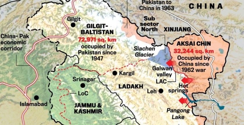
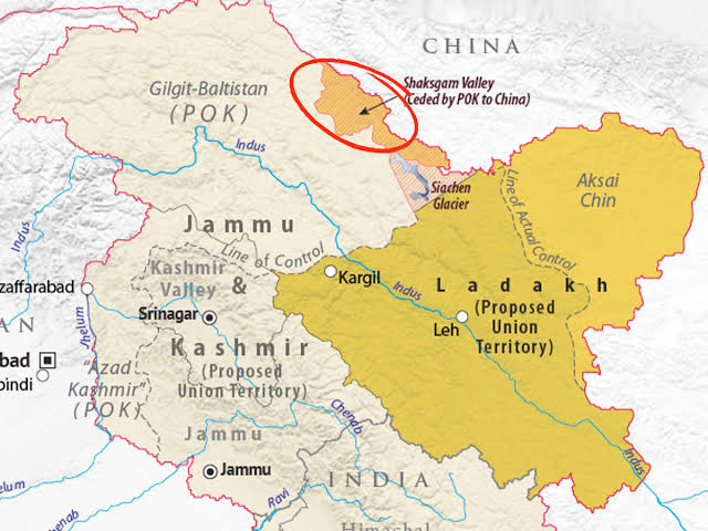
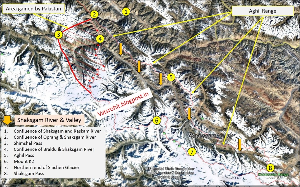
The Shaksgam valley also many times referred as the Trans-Karakoram Tract .
It has an area of more than 7,000 Sq . KM . Lies exactly between the Siachen Glacier by north and by south to the pamir plateau . It was historically part of india until Pak's hot an effecti control of the valley since 1948 . In 1962 the effective control f the valley was transferred to he China's PRC's . On 13 , october 1962 , it's effective control was transferred by the Pak's PM's Zurlifkar Ali Bhutto's in 1962 to Chinese Goverment's by the presence of the foreign ministers Chen Yi . After the Signing of the Agrement's of the Sino Pak's Friendship agrement's .
In 1959 the Pakistani government became concerned over Chinese maps that showed areas the Pakistanis considered their own as part of China. In 1961 Ayub Khan sent a formal note to China; there was no reply. It is thought that the Chinese might not have been motivated to negotiate with Pakistan because of Pakistan's relations with India. This was part of the Pak's startegy to subdue the Indian Infulence's by encouraging the PRC's to increase it's presence n the the Disputed area's .
Environment
While most of the valley lies in a lower area to the siachen's , most of it's is a made of mountains surrounded by vast barron's land's and and high altitude cimate's make it difficult fr any vegetation and life . The extreme tempatue's drops significantly during the night's. Abd during winter is covered by thin blanket of snow. Unlike Siachen Siachen meant's rapidly owing to it's location and lower altitude to the siachen's .
In next post's the presence of the Chinese's PLAGF's forces will be discussede's .
The wolf's Betweens the Sheep's .
The Presence of the PLAGF,s has been since the 1962's , the chinese deployment's was always limited's in the valley due to the extreme's distance and been unable to post any commander's due to the extreme's Terraine's and Climatic's Coditione's and unavalibility of the Infrastructure in the regione's to the Valley's .
But it's all change's in early 2000,s and with the expansion of the infrastructure to the valley , meant that the chinese were able to access the valley all year around . It's was further strengthened by the Construction of the variou's posts in and around the Valley's . The further implication happened since 2008's with construction of various infrastructure and structure's constructed to support a long time deployed Force's .
Importance of the Skasgam Valley to India .
The valley lies just west of the Karakoram Pasa means they the chinsea could easily access to our's DBO's road's and Ladakh's to a greater extent's and would result in an access to our's area's . The Chinese presence in the valley was always an alarming situation to us until the expansion of the chinese infracture's surrounding Ladakh's and other's area's resulting in a greater dia advantage to us that we had until now's . Another implicatione's is that we have rightful claim to the Saksgam valley's as part's of our's territory's that is occupied by the Chinese along with our's other's terrotrie's and area's .
Why the valley was ceaded ?
The Shaksgam Valley was ceded to China by Pakistan in 1963 when both countries signed a boundary agreement to settle their border differences. However, Article 6 clearly stated that “the two Parties have agreed that after the settlement of the Kashmir dispute between Pakistan and India, the sovereign authority concerned will reopen negotiations with the Government of the People's Republic of China, on the boundary as described in Article Two of the present Agreement, so as to sign a formal Boundary Treaty to replace the present agreement.” The agreement laid the foundation of Karakoram highway which was built jointly by the Chinese and Pakistani engineers in 1970s.
The Altitude Warfare's .
The High altitude war fare always is a challenge for any forces sheer ability to Climaticzied is an challenge for the terrain and the climatic conditione's of the Shaksgam valley and the continued deployment's .
Indian High Altitude Warfare School has one of the most experienced Discpline when it's lies to conductor's any operatione's and Warfare in such altitude and conditioner's . The experience gained after the Operatione's Meghdoot 's gives us an extreme potential to operate in such conditioner's and wage an effective's operatione's .
Operation's for thr Shaksgam Valley and it's battle order's .
The most suitable unit's for the operatione's in the Shaksgam valley would be the Divisione's and the Regiment's and brigade's .
Any success of any operatione's lies between the supply of Ratione's , ammunition and required equipment's needed for the operation .
The Shaksgam Valley's is the not the ideal location to carry out any military offensive operation's at one end is the impossible Siachen's Glaciers and on another the Pak's occupied Gilgit's and on the other hand is the Chines plateau and pain's the only location remain's for the effective's Logistic and supply would be the Karakoram Passe's .
But that will need to pass and potentially occupy an area's which is not claimed by India's . And stutaining it would be another challenge for any potential disrupt of the Logistic and Supply Route's .
In this terrain the armoured units will have little to no effect atleast in the initial operations but will be of the need for an RT's Support's to supress the enemy's position's and post's and use if RCL Gun's and Other rocket launchers could also be seen used in the Shaksgam Valley .
The Rehearsal before the Show's .
While the Mountede's Crope's have s high range of trainings but for the operation in the Shaksgam Valley's would require sn intense training and War exercises to able to perform and effectively educate any operation in the Terrain altitude and climatic conditions , environment to a total success .
Any operation of this large scale would be accompanied by an pre emptive strikes or paratroopar drope's . The first would be the use of the Para's to be dropped at the strategic locations already mentioned on the maps above . Capturing the key posts and counting to occupy till the relief party comes to the post held by the paratroopar through the road's .
The comman of chain for the paratroopar would be like this .
Can India successfully intrude by a similar operation like Meghdoot? Yes we can. But can we hold it? That's the real question.
However, how will India hold onto the Shaksgam valley ? It would mean we need to cross the Karakoram divide which in best of times is a pain.")
It is worthwhile to note that although it was handed over by Pakistan to China as part of the bilateral agreement, if India cannot get Gilgit-Baltistan, Shaksgam valley makes no sense. Any region one cannot hold onto or dominate is not viable. Also, what would be the strategic importance of such an act ?
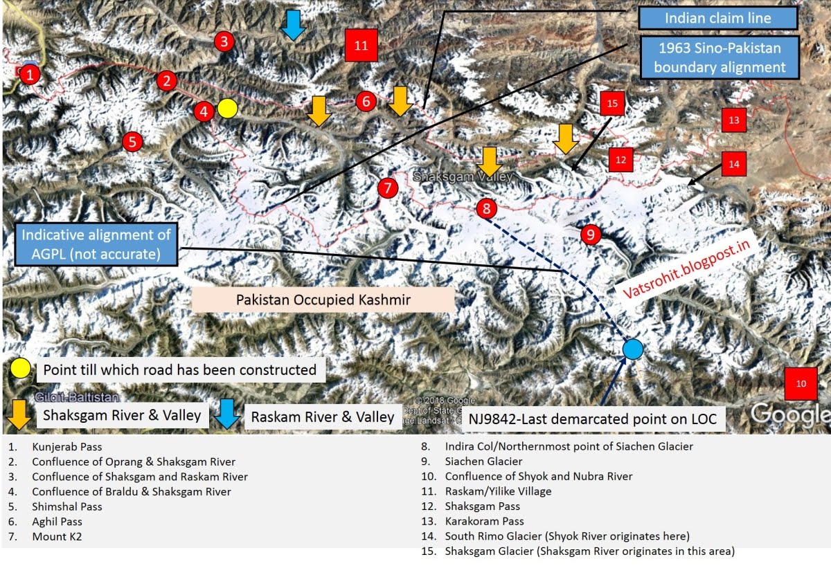
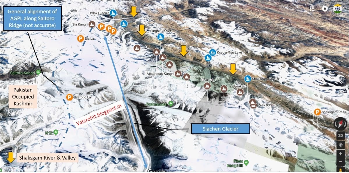
In current scenario, India shares a boundary with Shagsham valley by occupying the Siachen glacier and its tributaries. The feasible entry points would have to the Passess or openings in the Karakoram divide.
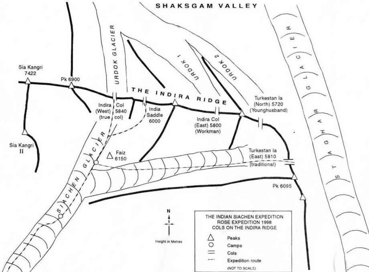
This include passess upon Indira ridge. crossing these very tough pass would take us onto the Urdok+Staghar glaciers which meets the Shagsham valley looking at the maps above
W Indira col
Main Indira col
Workmann
Turkmenistan La
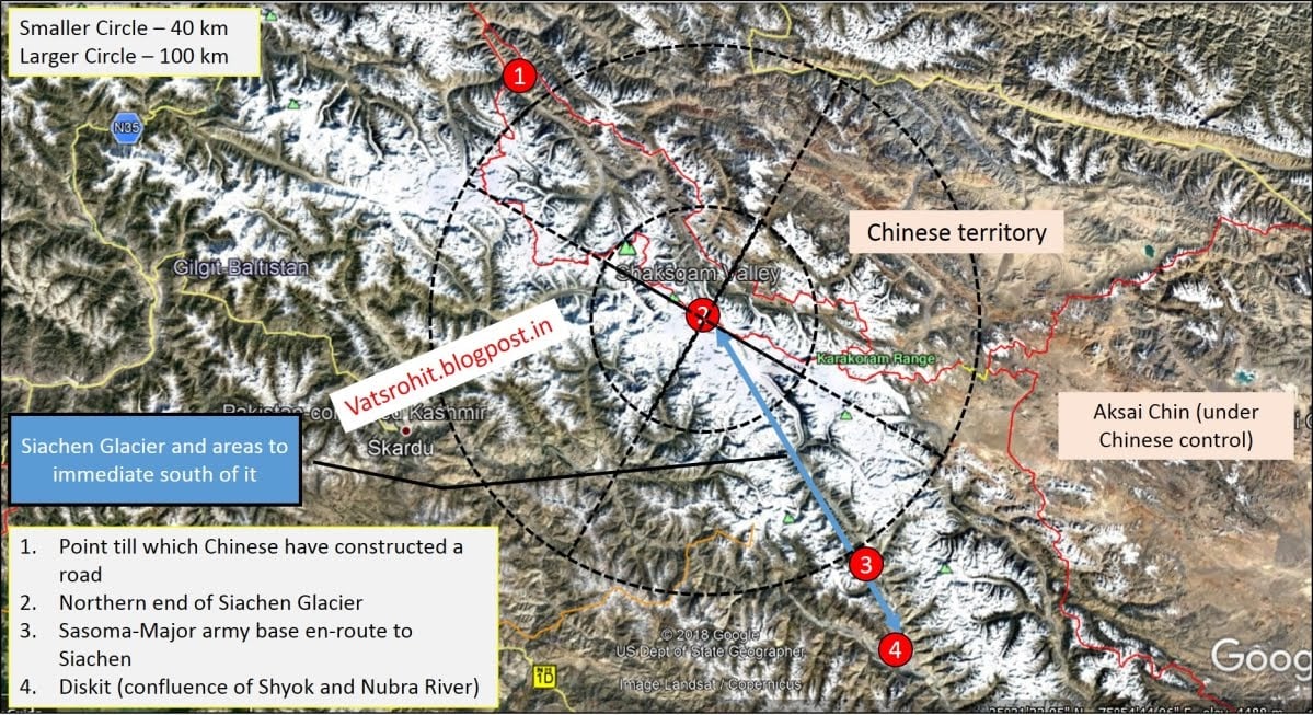
In addition on east side closer to Karakoram pass, we have the massive Teram Shehar plateau which opens up to Shakgsham pass. Terram Shehar is an absolute nightmare from logistics perspective. How do you maintain the logistics here? saddled between Siachen and Rimo glaciers.
I presume the Indira ridge that holds Indira Col (W & M) &Turkmenistanla has a steep slope on its north face, we have a clear view of Shaksham valley from there.
Another factor we need to mention here is Indian troops have to counter heavy presence of Pak Military on western side of Saltoro Range.
Further some observers mention that Shaksgam is easily accessible to Chinese side & is suitably connected & it is entirely administered by the People's Republic of China as a part of Kargilik County.
In my view either we first have to occupy entire GB to have better logistics or to dismantle Chinese from Karakoram pass to completely hold on the place.
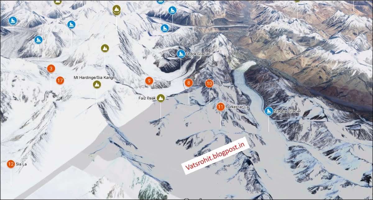
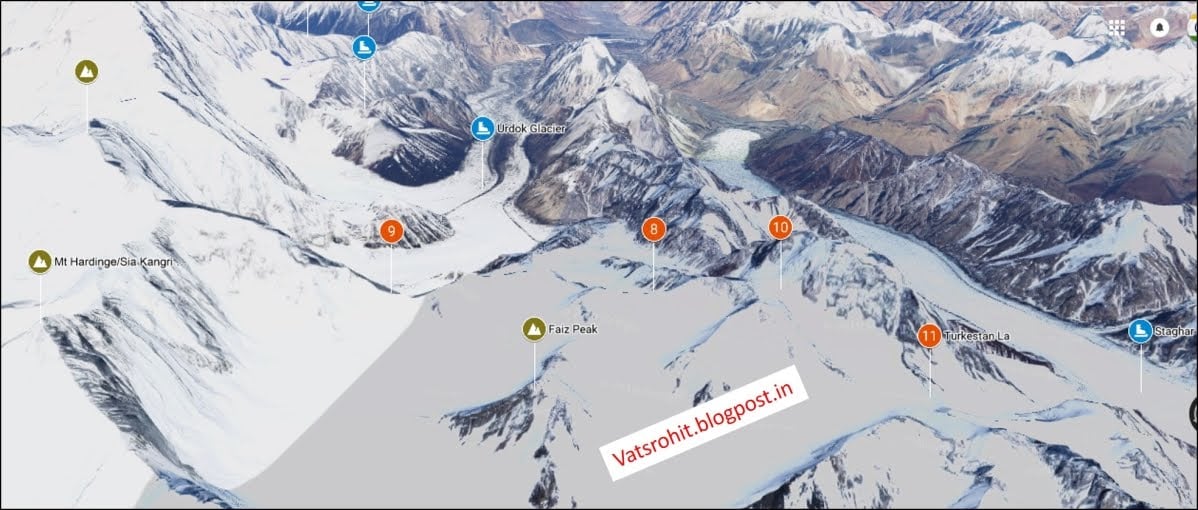
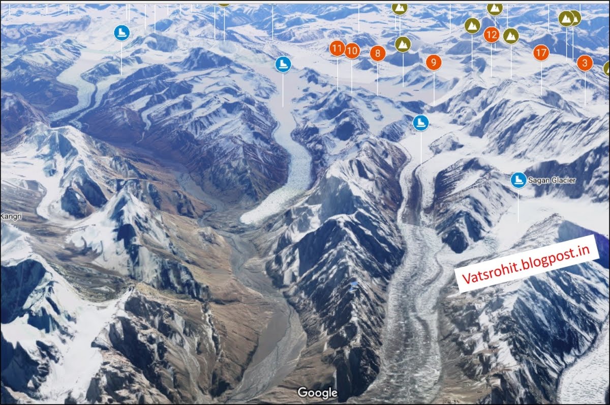
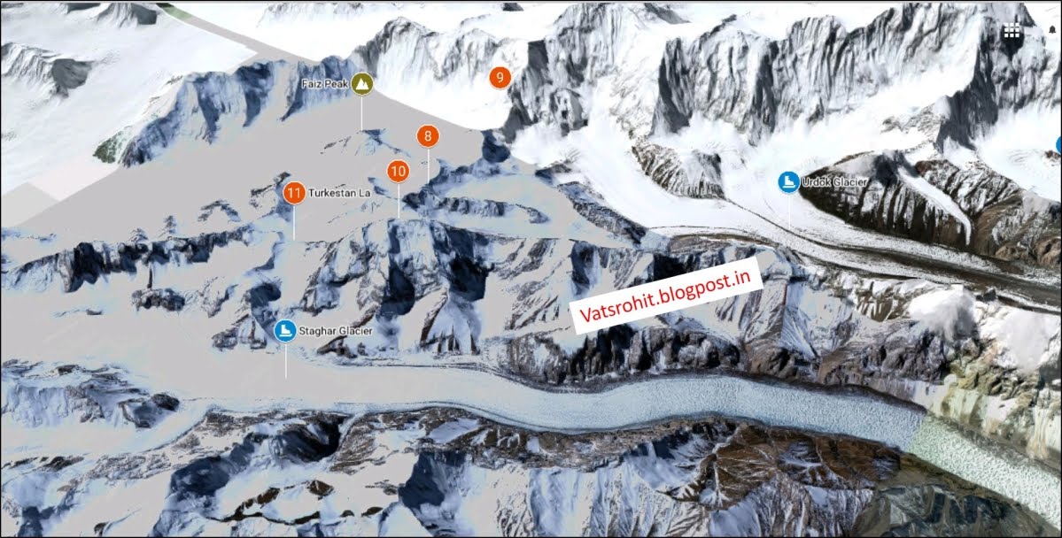
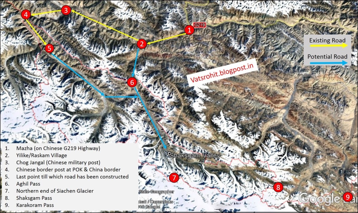
Source of photographe's VastsRohit's .
A detailed map explaining the current Situatione's in and around the Shaksgam Valley's .
Taking Back Gilgit Baltistan to support the operatione's in the Shaksgam Valley's
As we know our Government has repeatedly talked about taking back PoK when, now it is not certain. Will it ever happen? That's also a mystery. Media as usual talks about snatching PoK & GB from Pakistan in a chest thumping way without even telling the public how is that supposed to happen.
As we know Gilgit Baltistan was part of erstwhile Dogra Empire stretching as far as Hunza valley. Region is muslim dominant & now 100% muslim dominant. People at the time of partition wanted to stay with Pakistan but were ruled by a Hindu ruler. So Pakistan sent tribals & irregular soldiers in October 1947. There was mutiny by Gilgit scouts & it fell to Pakistan immediately. Since then it is occupied by Pakistan. Gilgit Baltistan was kept separated from so called Azad Kashmir (PoK). India never took interest in these regions as they believed they were pro Pakistanis & muslim & didn't wanted to add more Muslims in already muslim dominated state though we always claimed them & showed in our maps. AT the start of 21st century our interest is regenerated coz of its geopolitical importance. It can serve as our pathway to Central Asia & Afghanistan. CPEC is running through it & can be a great danger to our national security.
So let's see how can we try take out this big chunk of land from the grasp of Pakistan. We learned in Kargil that Mountain warfare can be a pain in the @s*. Pakistan army is in advantageous position there.
So air Assault is the way I think.
Ok, now that we have established the conditions under which an airborne assault on GB is likely to be the best way to take back the region short of going through the whole gamut of taking over all of POK, a much more humongous exercise, let’s see what we are up against.
Pak’s ORBAT (and here I will include paramilitary and local police also given their access to arms and potential of creating nuisance in the first few critical hours), comprises of Northern Areas Command of five independent brigades (~15000), Gilgit Baltistan Scouts ~3000, and Gilgit Baltistan Police ~5000. Say, an approximate total of 25,000 troops including auxiliaries and PAF assets at airfields.
A slug fight to defeat these troops is not in our best interest. Our assault needs to shock, decapitate command structures and bewilder the enemy into surrendering. Going out on a limb, I would hypothesize a missile barrage and IAF bombing to take out command centers, communications and eliminate at least 50% of the enemy (mostly the army). In such a context, hypothesizing further an airborne assault by 30,000 troops dropped into GB within a couple of hours (at least taking over airfields and road nodes) focusing on Skardu, Gilgit, Sost, Gajkuch, Danyor, Chilas, Astore. Later troops can spread out to take over rural areas (thankfully, with sparse population, it may be possible to focus on rural areas later). Crucial success factor will be intelligence and having locals friendly to Indian interests (particularly among tribals).
Since, now that we have defined the magnitude of the problem, let’s look into one aspect to explore further. We calculated 30,000 troops to be airdropped, airlifted to GB. That using Boeing C17’s or C130J’s represent 300 or 500 sorties respectively. Now, I would envision the airborne corps something like the Russian 7th Guards Mountain Air Assault Division, operating in principle like Mechanized infantry who are transported by air (refer herefor why I envision this).
We don't have such capability yet. But we can if we try. As we don't have 30,000 airborne troops.
The Para has been split into Para (SF) and Para and there are now only 4 vanilla Para bns which would be about 3600 troops. Yes we can add the para SF to the mix but in a scenario like you describe their utilisation to hold territory will be a sub-optimal use of that resource.
PS; It is part of destroying Paki capability in GB. Then of course we can launch full offensive assault in GB .
Contributed by @ARVION , @cereal killer , @mist_consecutive ,
and Special thanks to @utubekhiladi for asking the question Shaksgam mein Deesclation Hoga Kya ?


Prelude to the Shaksgam Valley's operatione's .
The importance of the Shaksgam Valley .
The Shaksgam valley also many times referred as the Trans-Karakoram Tract .
It has an area of more than 7,000 Sq . KM . Lies exactly between the Siachen Glacier by north and by south to the pamir plateau . It was historically part of india until Pak's hot an effecti control of the valley since 1948 . In 1962 the effective control f the valley was transferred to he China's PRC's . On 13 , october 1962 , it's effective control was transferred by the Pak's PM's Zurlifkar Ali Bhutto's in 1962 to Chinese Goverment's by the presence of the foreign ministers Chen Yi . After the Signing of the Agrement's of the Sino Pak's Friendship agrement's .
In 1959 the Pakistani government became concerned over Chinese maps that showed areas the Pakistanis considered their own as part of China. In 1961 Ayub Khan sent a formal note to China; there was no reply. It is thought that the Chinese might not have been motivated to negotiate with Pakistan because of Pakistan's relations with India. This was part of the Pak's startegy to subdue the Indian Infulence's by encouraging the PRC's to increase it's presence n the the Disputed area's .
Environment
While most of the valley lies in a lower area to the siachen's , most of it's is a made of mountains surrounded by vast barron's land's and and high altitude cimate's make it difficult fr any vegetation and life . The extreme tempatue's drops significantly during the night's. Abd during winter is covered by thin blanket of snow. Unlike Siachen Siachen meant's rapidly owing to it's location and lower altitude to the siachen's .
In next post's the presence of the Chinese's PLAGF's forces will be discussede's .
The wolf's Betweens the Sheep's .
The Presence of the PLAGF,s has been since the 1962's , the chinese deployment's was always limited's in the valley due to the extreme's distance and been unable to post any commander's due to the extreme's Terraine's and Climatic's Coditione's and unavalibility of the Infrastructure in the regione's to the Valley's .
But it's all change's in early 2000,s and with the expansion of the infrastructure to the valley , meant that the chinese were able to access the valley all year around . It's was further strengthened by the Construction of the variou's posts in and around the Valley's . The further implication happened since 2008's with construction of various infrastructure and structure's constructed to support a long time deployed Force's .
Importance of the Skasgam Valley to India .
The valley lies just west of the Karakoram Pasa means they the chinsea could easily access to our's DBO's road's and Ladakh's to a greater extent's and would result in an access to our's area's . The Chinese presence in the valley was always an alarming situation to us until the expansion of the chinese infracture's surrounding Ladakh's and other's area's resulting in a greater dia advantage to us that we had until now's . Another implicatione's is that we have rightful claim to the Saksgam valley's as part's of our's territory's that is occupied by the Chinese along with our's other's terrotrie's and area's .
Why the valley was ceaded ?
The Shaksgam Valley was ceded to China by Pakistan in 1963 when both countries signed a boundary agreement to settle their border differences. However, Article 6 clearly stated that “the two Parties have agreed that after the settlement of the Kashmir dispute between Pakistan and India, the sovereign authority concerned will reopen negotiations with the Government of the People's Republic of China, on the boundary as described in Article Two of the present Agreement, so as to sign a formal Boundary Treaty to replace the present agreement.” The agreement laid the foundation of Karakoram highway which was built jointly by the Chinese and Pakistani engineers in 1970s.
The Altitude Warfare's .
The High altitude war fare always is a challenge for any forces sheer ability to Climaticzied is an challenge for the terrain and the climatic conditione's of the Shaksgam valley and the continued deployment's .
Indian High Altitude Warfare School has one of the most experienced Discpline when it's lies to conductor's any operatione's and Warfare in such altitude and conditioner's . The experience gained after the Operatione's Meghdoot 's gives us an extreme potential to operate in such conditioner's and wage an effective's operatione's .
Operation's for thr Shaksgam Valley and it's battle order's .
The most suitable unit's for the operatione's in the Shaksgam valley would be the Divisione's and the Regiment's and brigade's .
- Mountain Corps
- IV Mountain Corps
- XXXIII Mountain Corps
- 17th Mountain Infantry Division
- 6th Mountain Infantry Division
- 8th Mountain Infantry Division
- 28th Mountain Infantry Division
- 77th Mountain Infantry Brigade “Chindits”
- 99th Mountain Brigade
- 9th Parachute Special Forces Battalion
- High Altitude Warfare School .
Any success of any operatione's lies between the supply of Ratione's , ammunition and required equipment's needed for the operation .
The Shaksgam Valley's is the not the ideal location to carry out any military offensive operation's at one end is the impossible Siachen's Glaciers and on another the Pak's occupied Gilgit's and on the other hand is the Chines plateau and pain's the only location remain's for the effective's Logistic and supply would be the Karakoram Passe's .
But that will need to pass and potentially occupy an area's which is not claimed by India's . And stutaining it would be another challenge for any potential disrupt of the Logistic and Supply Route's .
In this terrain the armoured units will have little to no effect atleast in the initial operations but will be of the need for an RT's Support's to supress the enemy's position's and post's and use if RCL Gun's and Other rocket launchers could also be seen used in the Shaksgam Valley .
The Rehearsal before the Show's .
While the Mountede's Crope's have s high range of trainings but for the operation in the Shaksgam Valley's would require sn intense training and War exercises to able to perform and effectively educate any operation in the Terrain altitude and climatic conditions , environment to a total success .
Any operation of this large scale would be accompanied by an pre emptive strikes or paratroopar drope's . The first would be the use of the Para's to be dropped at the strategic locations already mentioned on the maps above . Capturing the key posts and counting to occupy till the relief party comes to the post held by the paratroopar through the road's .
The comman of chain for the paratroopar would be like this .
- 1st Battalion (Special Forces)
- 2nd Battalion (Special Forces)
- 3rd Battalion (Special Forces)
- 4th Battalion (Special Forces)
- 5th Battalion
- 6th Battalion
- 7th Battalion
- 9th Battalion (Special Forces)
- 10th Battalion (Special Forces)
- 11th Battalion (Special Forces)
- 12th Battalion (Special Forces)
- 21st Battalion (Special Forces)
- 23rd Battalion
- 29th Battalion
- 31st Battalion (Rashtriya Rifles)
- 106th Infantry Battalion (Territorial Army) (based at Bengaluru, Karnataka)
- 116th Infantry Battalion (Territorial Army) (based at Devlali, Maharashtra) .
Can India successfully intrude by a similar operation like Meghdoot? Yes we can. But can we hold it? That's the real question.
However, how will India hold onto the Shaksgam valley ? It would mean we need to cross the Karakoram divide which in best of times is a pain.
It is worthwhile to note that although it was handed over by Pakistan to China as part of the bilateral agreement, if India cannot get Gilgit-Baltistan, Shaksgam valley makes no sense. Any region one cannot hold onto or dominate is not viable. Also, what would be the strategic importance of such an act ?
In current scenario, India shares a boundary with Shagsham valley by occupying the Siachen glacier and its tributaries. The feasible entry points would have to the Passess or openings in the Karakoram divide.
This include passess upon Indira ridge. crossing these very tough pass would take us onto the Urdok+Staghar glaciers which meets the Shagsham valley looking at the maps above
W Indira col
Main Indira col
Workmann
Turkmenistan La
In addition on east side closer to Karakoram pass, we have the massive Teram Shehar plateau which opens up to Shakgsham pass. Terram Shehar is an absolute nightmare from logistics perspective. How do you maintain the logistics here? saddled between Siachen and Rimo glaciers.
I presume the Indira ridge that holds Indira Col (W & M) &Turkmenistanla has a steep slope on its north face, we have a clear view of Shaksham valley from there.
Another factor we need to mention here is Indian troops have to counter heavy presence of Pak Military on western side of Saltoro Range.
Further some observers mention that Shaksgam is easily accessible to Chinese side & is suitably connected & it is entirely administered by the People's Republic of China as a part of Kargilik County.
In my view either we first have to occupy entire GB to have better logistics or to dismantle Chinese from Karakoram pass to completely hold on the place.
Source of photographe's VastsRohit's .
A detailed map explaining the current Situatione's in and around the Shaksgam Valley's .
Taking Back Gilgit Baltistan to support the operatione's in the Shaksgam Valley's
As we know our Government has repeatedly talked about taking back PoK when, now it is not certain. Will it ever happen? That's also a mystery. Media as usual talks about snatching PoK & GB from Pakistan in a chest thumping way without even telling the public how is that supposed to happen.
As we know Gilgit Baltistan was part of erstwhile Dogra Empire stretching as far as Hunza valley. Region is muslim dominant & now 100% muslim dominant. People at the time of partition wanted to stay with Pakistan but were ruled by a Hindu ruler. So Pakistan sent tribals & irregular soldiers in October 1947. There was mutiny by Gilgit scouts & it fell to Pakistan immediately. Since then it is occupied by Pakistan. Gilgit Baltistan was kept separated from so called Azad Kashmir (PoK). India never took interest in these regions as they believed they were pro Pakistanis & muslim & didn't wanted to add more Muslims in already muslim dominated state though we always claimed them & showed in our maps. AT the start of 21st century our interest is regenerated coz of its geopolitical importance. It can serve as our pathway to Central Asia & Afghanistan. CPEC is running through it & can be a great danger to our national security.
So let's see how can we try take out this big chunk of land from the grasp of Pakistan. We learned in Kargil that Mountain warfare can be a pain in the @s*. Pakistan army is in advantageous position there.
So air Assault is the way I think.
Ok, now that we have established the conditions under which an airborne assault on GB is likely to be the best way to take back the region short of going through the whole gamut of taking over all of POK, a much more humongous exercise, let’s see what we are up against.
Pak’s ORBAT (and here I will include paramilitary and local police also given their access to arms and potential of creating nuisance in the first few critical hours), comprises of Northern Areas Command of five independent brigades (~15000), Gilgit Baltistan Scouts ~3000, and Gilgit Baltistan Police ~5000. Say, an approximate total of 25,000 troops including auxiliaries and PAF assets at airfields.
A slug fight to defeat these troops is not in our best interest. Our assault needs to shock, decapitate command structures and bewilder the enemy into surrendering. Going out on a limb, I would hypothesize a missile barrage and IAF bombing to take out command centers, communications and eliminate at least 50% of the enemy (mostly the army). In such a context, hypothesizing further an airborne assault by 30,000 troops dropped into GB within a couple of hours (at least taking over airfields and road nodes) focusing on Skardu, Gilgit, Sost, Gajkuch, Danyor, Chilas, Astore. Later troops can spread out to take over rural areas (thankfully, with sparse population, it may be possible to focus on rural areas later). Crucial success factor will be intelligence and having locals friendly to Indian interests (particularly among tribals).
Since, now that we have defined the magnitude of the problem, let’s look into one aspect to explore further. We calculated 30,000 troops to be airdropped, airlifted to GB. That using Boeing C17’s or C130J’s represent 300 or 500 sorties respectively. Now, I would envision the airborne corps something like the Russian 7th Guards Mountain Air Assault Division, operating in principle like Mechanized infantry who are transported by air (refer herefor why I envision this).
We don't have such capability yet. But we can if we try. As we don't have 30,000 airborne troops.
The Para has been split into Para (SF) and Para and there are now only 4 vanilla Para bns which would be about 3600 troops. Yes we can add the para SF to the mix but in a scenario like you describe their utilisation to hold territory will be a sub-optimal use of that resource.
PS; It is part of destroying Paki capability in GB. Then of course we can launch full offensive assault in GB .
Contributed by @ARVION , @cereal killer , @mist_consecutive ,
and Special thanks to @utubekhiladi for asking the question Shaksgam mein Deesclation Hoga Kya ?
Last edited: