A.V.
New Member
- Joined
- Feb 16, 2009
- Messages
- 6,503
- Likes
- 1,157
American GPS
EU- GALILEO
Russian - GONASS
China - COMPASS
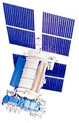
GLONASS
In some ways, the GLONASS program — after an allocation of more than 100 billion rubles (nearly $3 billion) in funding for its 2002–2011 modernization effort — has progressed most steadily in recent years.
With the three newest satellites from a launch last December now in operation, GLONASS has a 20-bird constellation — including 19 modernized space vehicles (SVs), the most in more than a decade. Some 17 of the spacecraft are broadcasting a second full civil signal on the GLONASS L2 frequency, the only such GNSS system doing so.
Its signal-in-space user range error (URE) is down to 1.8 meters — still high compared to GPS’s 1-meter URE, but within the 3.7 meters called for in the GLONASS Interface Control Document (ICD) and several times better than the UREs of just year ago. By the end of last year, GLONASS was typically providing a standalone receiver with five-meter positioning accuracy using pseudoranges.
Launches have taken place regularly as scheduled over the past few years, and another six satellites are set to go up in triple launches in October and December this year. If successful, that should bring the GLONASS constellation to full operational capability (FOC) with 24 satellites early in 2010.
But that’s not all. The next-generation GLONASS-K will begin launching next year and include a CDMA (code division multiple access) signal on L3, which will more closely align with other GNSS systems that the system’s legacy frequency division multiple access (FDMA) design.
A decision about new GLONASS signals at the L1C and L5 frequencies depends on negotiations by a U.S./Russia working group, but could lead to additional CDMA signals, said Sergey Revnivykh, deputy director of the Russian space agency’s Mission Control Center.
The stable progress in rebuilding and modernizing GLONASS has even drawn interest from players in the mobile phone industry. Nokia has been investigating the use of GLONASS for its handsets. And, at the Munich summit, Frank van Diggelen, technical director and chief navigation officer for Broadcom Corporation, a semiconductor company that targets mobile handset manufacturers, appeared to compare GLONASS’s prospects favorably to Galileo.
“If GLONASS, which almost has a complete constellation, finds its way onto consumer devices, then consumers will have access to 65 satellites (GPS 31 + SBAS 7 + QZSS 3 + GLONASS 24 = 65),” van Diggelen said. “This may be enough.” In a worrisome aside for Europe’s system, which is counting on mobile phones playing a prominent role in downstream markets, he added, “Galileo may simply be too late to matter.”
COMPASS
As for Compass, if China executes its currently announced schedule for satellite launches, it would mark a substantial acceleration in that program. Given the caution with which Chinese officials have announced their plans, the 10 satellites in two years commitment could well be met.
Indeed, a Chinese representative indicated that the Compass program is under pressure from Beijing to show progress in bringing the planned five civil and five restricted services online. The schedule also suggests that China has a lot of satellites already built and ready to fly soon.
Autonomous positioning accuracy for the open service is expected to be at least 10 meters, according to Jing Guifei, chief of the international cooperation division in the National Remote Sensing Center of China (NRSCC). A wide area differential service providing one-meter real-time positioning and a short message service (SMS) is also part of the Compass program, Jing said.
As the “newcomer” to the GNSS field, in the words of Yin Jun, director of the European Affairs Division of China’s Ministry of Science and Technology (MOST), Compass “is not in the same place at the start of the race.”
Yin stressed that GNSS should not be a “competitive” exercise. “We need coordination among system providers,” he said. Although a “regional” capability is expected once the first 10 Compass satellites are in place, Yin said a global Compass service would not arrive until between 2015 and 2020.
GPS
As the leading GNSS provider, the United States might be thought to have the luxury of improving on a real and existing system with 31 operational SVs on orbit. In fact, the GPS program is in the midst of a full-blown modernization phase.
Launch of a modernized GPS Block IIR satellite — SV IIR-20(M) — is scheduled for March 24, the first since discovery of a faulty component in the Delta 2 booster last June led to a suspension of launches. A demonstration payload for the new L5 civil signal is on the IIR-20(M), and faces an August 2009 deadline to meet an International Telecommunications Union requirement for securing primary GPS access to the frequency.
The last IIR-M should go up in August, according to Col. Dave Buckman, PNT command lead for Air Force Space Command at Peterson Air Force Base, Colorado.
Launch of the first Block IIF spacecraft is scheduled for October 2009, although anomalies discovered in the signal generator of the second IIF now under construction has introduced some uncertainty into the plan.
GPS produced a one-meter URE in 2008, Buckman said. The GPS III satellites, which will carry the new civil L1C signal, are designed to have a URE that is four times better.
Galileo
Turning at last to Europe’s Galileo, the laborious process of contracting out the fully operational capability (FOC) system development continues. In Munich, Fotis Karamitsos, European Commission director-general for transport and energy, and Paul Verhoef, head of the Galileo unit, indicated that agreements with companies winning the lead contracts for six work packages should be signed between September and the end of this year.
Discussions at the Summit revealed tensions around negotiations with China about a frequency overlay of Compass signals on the security-oriented Public Regulated Service as well as the question of whether the costs to build Galileo can be kept within the €3.4-billion limit agreed by the European Council and the European Parliament.
In answer to a question at the March 3 opening plenary, Karamitsos insisted that “we have no reason to believe that FOC won’t be delivered on time and on budget.”
Responding to a comment that “several member states” and private companies have already suggested creating a “light” version of Galileo — fewer services, signals, and/or satellites, Karamitsos said he that the European Union (EU) member states have a “legal obligation to deliver the full system. Galileo satellites will be acquired in blocks of 10, 8, and 8.
Karamitsos complained of “people negotiating through the press,” adding, “In this time of economic constraints it doesn’t make sense for our industry to try to make money over” the amount allocated for the program.
According to one European source, the reference was to Surrey Satellite Technology Ltd. (SSTL), a UK firm whose acquisition by EADS Astrium closed in January as well as EU members uninterested in using the PRS. SSTL, which specializes in smaller, economical satellite designs, built Galileo’s GIOVE-A satellite now in orbit.
Phil Davies, SSTL’s business development manager, acknowledges that “we've been pushing the idea of ‘Early Services’ for several years now, but I must admit it's an uphill struggle trying to single-handedly revector the Galileo juggernaut.”
Davies referred to a December 17, 2007, op-ed article that he wrote for Space News that he believes “probably remains valid today.”
In that commentary, Davies argued, “Whilst the full set of services might seem attractive it is clear that a simpler specification could be implemented more rapidly and at lower cost with minimal controversy and less demands on the ground segment.
“Such a system would allow Europe to achieve some of the strategic aims for Galileo such as the political and economic benefits,” the op-ed column continued. “Additional services, if shown to be cost beneficial, could be introduced on later batches of satellites that are now planned to be contracted after 2008. In this way Galileo could become an evolving system, rather like GPS with its different blocks of satellites.”
SSTL, along with its bidding partner OHB System AG (OHB), has been short-listed as a candidate for the Galileo FOC space segment (with EADS as the other contender) and are preparing for the submission of a “refined proposal” to the European Space Agency.
GPS, GLONASS, Galileo, Compass: What GNSS Race? What Competition | Inside GNSS
EU- GALILEO
Russian - GONASS
China - COMPASS
GLONASS
In some ways, the GLONASS program — after an allocation of more than 100 billion rubles (nearly $3 billion) in funding for its 2002–2011 modernization effort — has progressed most steadily in recent years.
With the three newest satellites from a launch last December now in operation, GLONASS has a 20-bird constellation — including 19 modernized space vehicles (SVs), the most in more than a decade. Some 17 of the spacecraft are broadcasting a second full civil signal on the GLONASS L2 frequency, the only such GNSS system doing so.
Its signal-in-space user range error (URE) is down to 1.8 meters — still high compared to GPS’s 1-meter URE, but within the 3.7 meters called for in the GLONASS Interface Control Document (ICD) and several times better than the UREs of just year ago. By the end of last year, GLONASS was typically providing a standalone receiver with five-meter positioning accuracy using pseudoranges.
Launches have taken place regularly as scheduled over the past few years, and another six satellites are set to go up in triple launches in October and December this year. If successful, that should bring the GLONASS constellation to full operational capability (FOC) with 24 satellites early in 2010.
But that’s not all. The next-generation GLONASS-K will begin launching next year and include a CDMA (code division multiple access) signal on L3, which will more closely align with other GNSS systems that the system’s legacy frequency division multiple access (FDMA) design.
A decision about new GLONASS signals at the L1C and L5 frequencies depends on negotiations by a U.S./Russia working group, but could lead to additional CDMA signals, said Sergey Revnivykh, deputy director of the Russian space agency’s Mission Control Center.
The stable progress in rebuilding and modernizing GLONASS has even drawn interest from players in the mobile phone industry. Nokia has been investigating the use of GLONASS for its handsets. And, at the Munich summit, Frank van Diggelen, technical director and chief navigation officer for Broadcom Corporation, a semiconductor company that targets mobile handset manufacturers, appeared to compare GLONASS’s prospects favorably to Galileo.
“If GLONASS, which almost has a complete constellation, finds its way onto consumer devices, then consumers will have access to 65 satellites (GPS 31 + SBAS 7 + QZSS 3 + GLONASS 24 = 65),” van Diggelen said. “This may be enough.” In a worrisome aside for Europe’s system, which is counting on mobile phones playing a prominent role in downstream markets, he added, “Galileo may simply be too late to matter.”
COMPASS
As for Compass, if China executes its currently announced schedule for satellite launches, it would mark a substantial acceleration in that program. Given the caution with which Chinese officials have announced their plans, the 10 satellites in two years commitment could well be met.
Indeed, a Chinese representative indicated that the Compass program is under pressure from Beijing to show progress in bringing the planned five civil and five restricted services online. The schedule also suggests that China has a lot of satellites already built and ready to fly soon.
Autonomous positioning accuracy for the open service is expected to be at least 10 meters, according to Jing Guifei, chief of the international cooperation division in the National Remote Sensing Center of China (NRSCC). A wide area differential service providing one-meter real-time positioning and a short message service (SMS) is also part of the Compass program, Jing said.
As the “newcomer” to the GNSS field, in the words of Yin Jun, director of the European Affairs Division of China’s Ministry of Science and Technology (MOST), Compass “is not in the same place at the start of the race.”
Yin stressed that GNSS should not be a “competitive” exercise. “We need coordination among system providers,” he said. Although a “regional” capability is expected once the first 10 Compass satellites are in place, Yin said a global Compass service would not arrive until between 2015 and 2020.
GPS
As the leading GNSS provider, the United States might be thought to have the luxury of improving on a real and existing system with 31 operational SVs on orbit. In fact, the GPS program is in the midst of a full-blown modernization phase.
Launch of a modernized GPS Block IIR satellite — SV IIR-20(M) — is scheduled for March 24, the first since discovery of a faulty component in the Delta 2 booster last June led to a suspension of launches. A demonstration payload for the new L5 civil signal is on the IIR-20(M), and faces an August 2009 deadline to meet an International Telecommunications Union requirement for securing primary GPS access to the frequency.
The last IIR-M should go up in August, according to Col. Dave Buckman, PNT command lead for Air Force Space Command at Peterson Air Force Base, Colorado.
Launch of the first Block IIF spacecraft is scheduled for October 2009, although anomalies discovered in the signal generator of the second IIF now under construction has introduced some uncertainty into the plan.
GPS produced a one-meter URE in 2008, Buckman said. The GPS III satellites, which will carry the new civil L1C signal, are designed to have a URE that is four times better.
Galileo
Turning at last to Europe’s Galileo, the laborious process of contracting out the fully operational capability (FOC) system development continues. In Munich, Fotis Karamitsos, European Commission director-general for transport and energy, and Paul Verhoef, head of the Galileo unit, indicated that agreements with companies winning the lead contracts for six work packages should be signed between September and the end of this year.
Discussions at the Summit revealed tensions around negotiations with China about a frequency overlay of Compass signals on the security-oriented Public Regulated Service as well as the question of whether the costs to build Galileo can be kept within the €3.4-billion limit agreed by the European Council and the European Parliament.
In answer to a question at the March 3 opening plenary, Karamitsos insisted that “we have no reason to believe that FOC won’t be delivered on time and on budget.”
Responding to a comment that “several member states” and private companies have already suggested creating a “light” version of Galileo — fewer services, signals, and/or satellites, Karamitsos said he that the European Union (EU) member states have a “legal obligation to deliver the full system. Galileo satellites will be acquired in blocks of 10, 8, and 8.
Karamitsos complained of “people negotiating through the press,” adding, “In this time of economic constraints it doesn’t make sense for our industry to try to make money over” the amount allocated for the program.
According to one European source, the reference was to Surrey Satellite Technology Ltd. (SSTL), a UK firm whose acquisition by EADS Astrium closed in January as well as EU members uninterested in using the PRS. SSTL, which specializes in smaller, economical satellite designs, built Galileo’s GIOVE-A satellite now in orbit.
Phil Davies, SSTL’s business development manager, acknowledges that “we've been pushing the idea of ‘Early Services’ for several years now, but I must admit it's an uphill struggle trying to single-handedly revector the Galileo juggernaut.”
Davies referred to a December 17, 2007, op-ed article that he wrote for Space News that he believes “probably remains valid today.”
In that commentary, Davies argued, “Whilst the full set of services might seem attractive it is clear that a simpler specification could be implemented more rapidly and at lower cost with minimal controversy and less demands on the ground segment.
“Such a system would allow Europe to achieve some of the strategic aims for Galileo such as the political and economic benefits,” the op-ed column continued. “Additional services, if shown to be cost beneficial, could be introduced on later batches of satellites that are now planned to be contracted after 2008. In this way Galileo could become an evolving system, rather like GPS with its different blocks of satellites.”
SSTL, along with its bidding partner OHB System AG (OHB), has been short-listed as a candidate for the Galileo FOC space segment (with EADS as the other contender) and are preparing for the submission of a “refined proposal” to the European Space Agency.
GPS, GLONASS, Galileo, Compass: What GNSS Race? What Competition | Inside GNSS