
OSINT from Satellite images
- Thread starter sayareakd
- Start date
More options
Who Replied?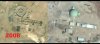
")
sayareakd
Mod
- Joined
- Feb 17, 2009
- Messages
- 17,734
- Likes
- 18,952
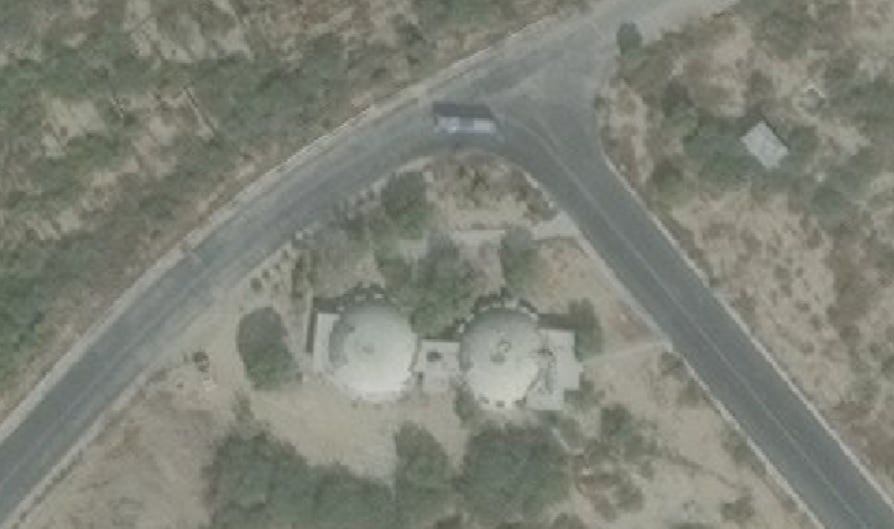
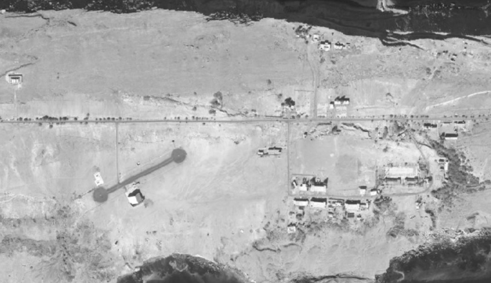
Its in Sargodha in PakistanTPS77 radar station in Pakistan.
View attachment 22811
Looks like some underground structure near by.
Just left side where the airstrip comes to end.
captscooby81
Senior Member
- Joined
- Dec 25, 2016
- Messages
- 7,065
- Likes
- 26,963
List out the locations here which you guys want to see i can pull up from the server the latest images as of October 2017 ...
- Joined
- Jun 5, 2017
- Messages
- 16,330
- Likes
- 70,173
@sayareakd sir which app do u use to get these images.
Arihant Roy
Senior Member
- Joined
- Jan 25, 2018
- Messages
- 1,493
- Likes
- 12,474
Let's start with Rambilli. That hill at the mouth of the delta.List out the locations here which you guys want to see i can pull up from the server the latest images as of October 2017 ...
captscooby81
Senior Member
- Joined
- Dec 25, 2016
- Messages
- 7,065
- Likes
- 26,963
@Arihant Roy Nothing much there to see in Rambili now its as good as its shown in google earth apart from few roads and blocks have come up ....
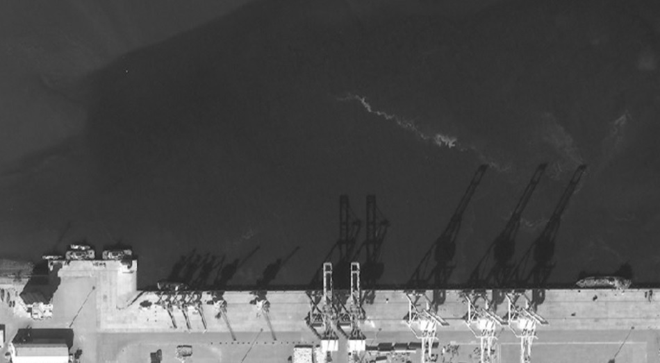
PAF Masroor Karachi
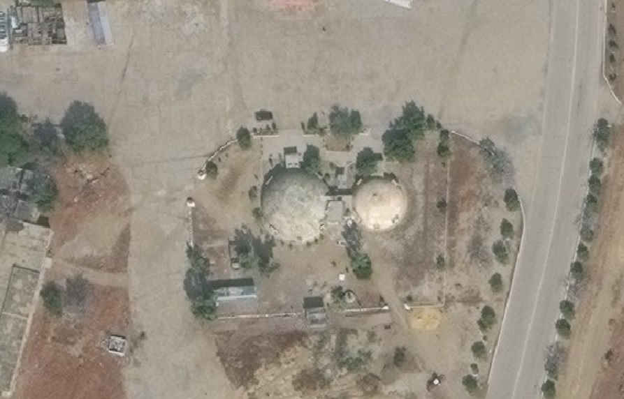
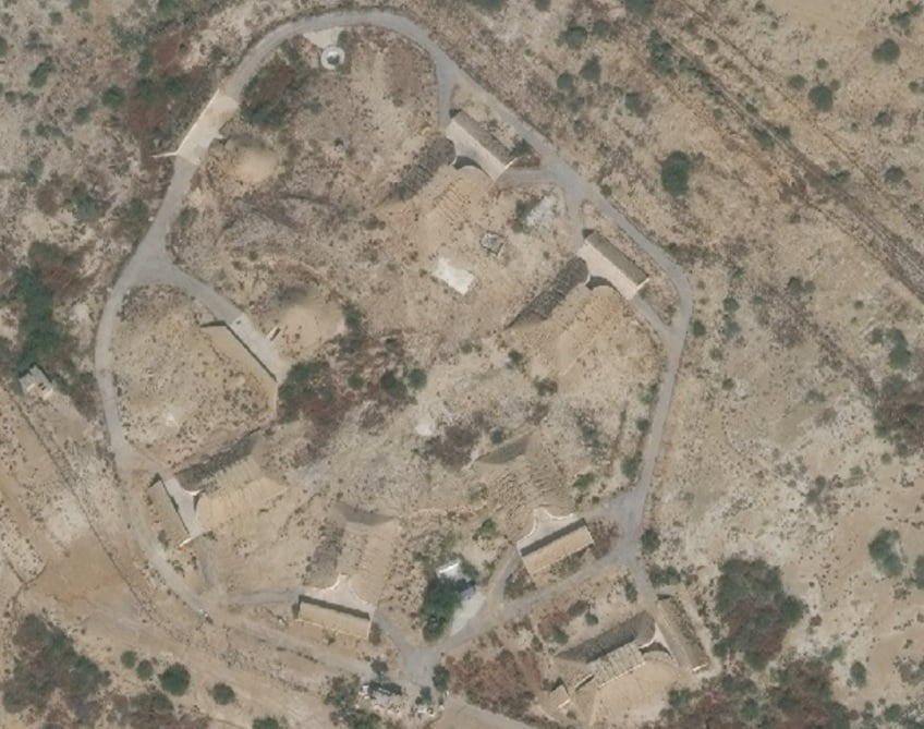
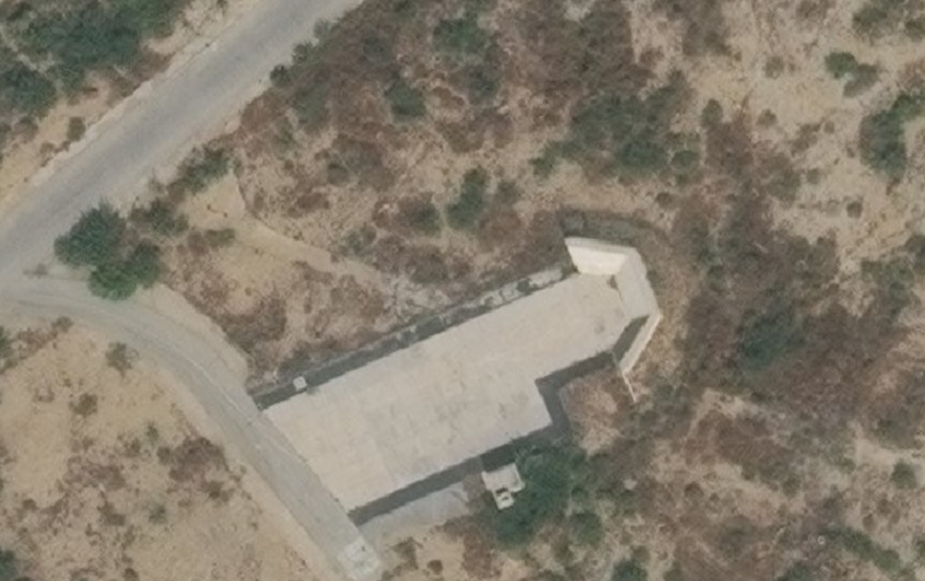
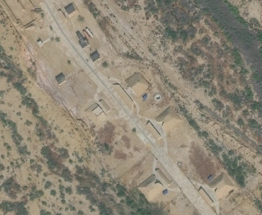
This one site is just outside the Base but very close to the boundary wall

PAF Masroor Karachi
This one site is just outside the Base but very close to the boundary wall
Let's start with Rambilli. That hill at the mouth of the delta.
captscooby81
Senior Member
- Joined
- Dec 25, 2016
- Messages
- 7,065
- Likes
- 26,963
Gwadar .................
- Joined
- May 21, 2016
- Messages
- 3,814
- Likes
- 19,544
Since we have a dedicated thread,I would like to ask all geography enthusiasts about some applications which are good to get such images.
I mean everybody is familiar with Google Earth and so,but what are some lesser known apps/websites similar to it ?
I know one,Wikimapia.
I mean everybody is familiar with Google Earth and so,but what are some lesser known apps/websites similar to it ?
I know one,Wikimapia.
captscooby81
Senior Member
- Joined
- Dec 25, 2016
- Messages
- 7,065
- Likes
- 26,963
Bhuvan ,bing maps, Google Earth,Earth3D,
Since we have a dedicated thread,I would like to ask all geography enthusiasts about some applications which are good to get such images.
I mean everybody is familiar with Google Earth and so,but what are some lesser known apps/websites similar to it ?
I know one,Wikimapia.
Open any famous place in Wikipedia. .on top right corner there are coordinates. Open in new tabSince we have a dedicated thread,I would like to ask all geography enthusiasts about some applications which are good to get such images.
I mean everybody is familiar with Google Earth and so,but what are some lesser known apps/websites similar to it ?
I know one,Wikimapia.
There are around 10 15 options including Google maps., Apple , wikimapia, here maps. , Terra etc.
Can anyone help analyse specific radars, Air defence locations , vehicles in these sites . Etc@Arihant Roy Nothing much there to see in Rambili now its as good as its shown in google earth apart from few roads and blocks have come up ....
PAF Masroor Karachi
View attachment 22818 View attachment 22819 View attachment 22820 View attachment 22821 View attachment 22822 View attachment 22823
This one site is just outside the Base but very close to the boundary wall
View attachment 22824
Strength etc
Possibility of nuke weapon storage.
indiatester
Senior Member
- Joined
- Jul 4, 2013
- Messages
- 5,843
- Likes
- 20,235
Add planet.com , https://cartifact.com/ , and map quest.Since we have a dedicated thread,I would like to ask all geography enthusiasts about some applications which are good to get such images.
I mean everybody is familiar with Google Earth and so,but what are some lesser known apps/websites similar to it ?
I know one,Wikimapia.
sayareakd
Mod
- Joined
- Feb 17, 2009
- Messages
- 17,734
- Likes
- 18,952
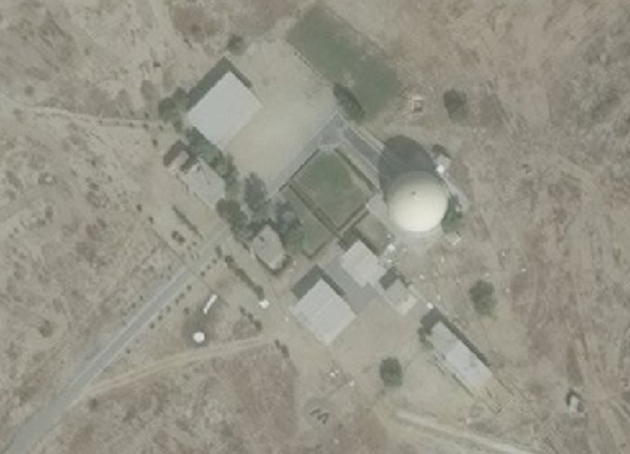
TPS77 radar station in Pakistan.
View attachment 22811
Looks like some underground structure near by.
this shows the location of the structure and the GPS coordinates.
sayareakd
Mod
- Joined
- Feb 17, 2009
- Messages
- 17,734
- Likes
- 18,952
indiatester
Senior Member
- Joined
- Jul 4, 2013
- Messages
- 5,843
- Likes
- 20,235
TPS-77 should look like this.

https://www.lockheedmartin.com/us/products/ground-based-air-surveillance.html
The dome may be a different radar?
| Thread starter | Similar threads | Forum | Replies | Date |
|---|---|---|---|---|
|
|
DFIlite twitter OSINT post | OSINT | 22 | |
|
|
OSINT Images Contribution | Members Corner | 69 | |
|
|
DFI OSINT Images Contribution. | OSINT | 8 | |
| H | OSINT compilation thread | Knowledge Repository | 54 |
Latest Replies
-
 General History Thread
- Azaad
-
 China Economy: News & Discussion
- SexyChineseLady
-
 Failed Terrorist State of Pakistan: Idiotic Musings
- FalconSlayers
-
World Military/Paramilitary/Special Forces
- Zoid Raptor
-
 DRDO, PSU and Private Defence Sector News
- Arjun Mk1A
-
 Infrastructure and Energy Sector
- Atavistic
-
Indian Air Force: News & Discussions
- SilentlAssassin265
-
 ADA Tejas Mark-II/Medium Weight Fighter
- Tejbrahmastra
-
 Israel - Hamas Gaza Conflict Oct-2023
- Blademaster
-
 Indian Special Forces
- NoobWannaLearn
Global Defence
-
World Military/Paramilitary/Special Forces
- Zoid Raptor
-
Turkish defense industry news updates
- Blademaster
-
Small arms and Light Weapons
- NoobWannaLearn
-
 Sukhoi PAK FA
- StealthFlanker
-
 Japan Self Defense Forces - Pictures & Videos
- Love Charger
-
 F-35 Joint Strike Fighter
- binayak95
-
 Aircraft Crash Notification
- vishnugupt
New threads
-
An Indian Admiral and a pakistani Air Commodore
- Zoid Raptor
- Replies: 0
-
 First Asian on the Moon will be a Japanese astronaut
- skywatcher
- Replies: 0
-
 Iran Israel conflict
- patriots
- Replies: 43
Articles
-
 India Strikes Back: Operation Snow Leopard - Part 1
- mist_consecutive
- Replies: 9
-
Aftermath Galwan : Who holds the fort ?
- mist_consecutive
- Replies: 33
-
 The Terrible Cost of Presidential Racism(Nixon & Kissinger towards India).
- ezsasa
- Replies: 40
-
Modern BVR Air Combat - Part 2
- mist_consecutive
- Replies: 22
-
Civil & Military Bureaucracy and related discussions
- daya
- Replies: 32