India-China 2020 Border conflict

Status
Not open for further replies.

Lost user

Tihar Jail
Banned
Joined
Feb 9, 2021
Messages
2,181
Likes
10,450
Country flag

Pentagon's librandu in chief for foreign policy jacky boy interview wid stratnews....

Watch d tone..Some of d gems from interview..
India can be "FORGIVEN" for s400 if India buys thaad..
Hooman rights as bargaining chip as usual..
India should offer Muricans a fucking military base in Andamans ( At this point i absolutely have no idea what to say)....
Just my hunch, and most likely wrong: There will be no US sanctions.. Because, India is the only nation, which does not mind shedding its own blood fighting a great power, or shedding Chinese blood.. or bombing sovereign territory of another nuclear power..
I don't think these western woke fag*ots are ready to shed blood, on a scale , that a great power war entails.. And they can't do it without India..
Note: The above might be inspired from watching Singham on a loop..:india2:
 

ezsasa

Designated Cynic
Mod
Joined
Jul 12, 2014
Messages
31,919
Likes
148,066
Country flag
Ya'll Nibbiars
Looks like the blue coat dumbass doesn’t know that the concept of Quad was first publicly revealed by prime minister abe in India, he is talking as if India is an outsider in quad being invited by US. Murican exceptionalism much...

If murican middle level bureaucrats stick to these world Phamus negotiation tactics, CCP will win the new Cold War before it even starts.

This is where Ashok malik’s points become noteworthy..
========
The outcome is an imminent crisis of irrelevance. As a discipline, South Asia studies is not updating itself. A gap in comprehension is emerging; it will eventually become unsustainable. It will also limit influence on policy design, insofar as that is an academic motivation 3/3.


Last edited:

mist_consecutive

Golgappe Expert
Contributor
Joined
Oct 2, 2018
Messages
4,896
Likes
41,345
Country flag
@mist_consecutive


Your area get interpretation from this on your pics not saying anything more
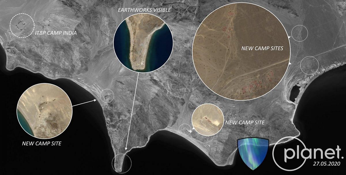
In our scans of the area, we were not able to detect any intrusions by the Chinese across the red line in Image 2 above. We did, however, notice several Indian and Chinese minor posts, with probably no more than 3 to 5 persons each, facing the red line within their respective territories. No Chinese post was observed between the red and yellow lines.
Incorrect lines are marked in red.

The "red" line, according to Abhijit Iyer Mitra, which he says is Indian interpretation of LAC, is also Google's marked LAC line. Chinese post is 1.7 km inside (towards our side) according to Feb 2021 satellite image.

Mate, no point fighting or trying to prove me wrong. I speak what satellite images show me.
 

doreamon

Senior Member
Joined
Mar 24, 2019
Messages
3,007
Likes
15,162
Country flag
If murican middle level bureaucrats stick to these world Phamus notiotiation tactics, CCP will win the new Cold War before it even starts.

This is where Ashok malik’s points become noteworthy..
========
The outcome is an imminent crisis of irrelevance. As a discipline, South Asia studies is not updating itself. A gap in comprehension is emerging; it will eventually become unsustainable. It will also limit influence on policy design, insofar as that is an academic motivation 3/3.


Some good comments on that thread


Abdus Salem killed

New Member
Joined
Mar 10, 2021
Messages
4,103
Likes
15,759
Incorrect lines are marked in red.

The "red" line, according to Abhijit Iyer Mitra, which he says is Indian interpretation of LAC, is also Google's marked LAC line. Chinese post is 1.7 km inside (towards our side) according to Feb 2021 satellite image.

Mate, no point fighting or trying to prove me wrong. I speak what satellite images show me.
The red line is the Google earth LAC

the grey yellow line is the Chinese LAC

See both Google earth and open street map if you don't believe me

Not trying to prove you wrong
 
Last edited:

doreamon

Senior Member
Joined
Mar 24, 2019
Messages
3,007
Likes
15,162
Country flag
No, we fight China's superiority complex, like we did at Galwan, and Pakistan's 2-front Ghazwa wet-dream.
Buying THAAD patriot pac 3 so that we can buy s400 😅 ... we have our own BMD system .with that money we can provide 3 layer protection to all major cities . And regarding non balistic targets besides s400 in future we have our own indo isreali missiles .. XRSAM ll be ready to be inducted very soon . Qrsam ll also be ready soon which is NASAM 2 catagory .
If usa willing to sell F15ex fighter jet as a negotiation we shd opt for that . We have real shortage of modern fighter jets .It ll provide us weapon system far surpassing meteor in near future .
 

mist_consecutive

Golgappe Expert
Contributor
Joined
Oct 2, 2018
Messages
4,896
Likes
41,345
Country flag
The red line is not the Google LAC it's the Chinese lac
the grey line is the Chinese LAC
See both Google earth and open street map if you don't believe me
Okay, I realize the red-grey line got us confused regarding what we are actually referring to. Let me pull out the article.

Image 1 shows the location of the Gogra region with respect to Pangong, sourced from Chinese mapping company AutoNavi and superimposed on OpenStreetMap. The red arrow points to the Gogra region. Near the arrow is a faint grey line, which is the Indian interpretation of the Line of Actual Control (LAC), and a red U-curve, which is the Chinese interpretation.


Image 1 - From Chinese company Autonavi, and superimposed over OpenStreetMap

Image 2 shows both Indian (red) and Chinese (yellow) interpretations of the LAC stencilled by hand onto the layout of the area. Four points of interest are marked with yellow pins. The Indian base can be seen at the south, whereas two points of concern (POC) can be seen to its north and one point of concern to its east. All 3 POCs are well inside the Chinese side of the LAC.


Image 2 - Probably from Google Earth

In our scans of the area, we were not able to detect any intrusions by the Chinese across the red line in Image 2 above. We did, however, notice several Indian and Chinese minor posts, with probably no more than 3 to 5 persons each, facing the red line within their respective territories. No Chinese post was observed between the red and yellow lines.
Observation 1:- Focusing only upon HotSpring region, Image 1 red line U-curve = Image 2 yellow line U-curve.
Observation 2:- Focusing only upon HotSpring region, Image 1 grey line at arrow = Image 2 red line above the yellow u-curve.

Now that we have ascertained what means what, I will now use only Image 2 in my below arguments.

From Image 2, observations, red line - Indian definition of LAC, yellow line - China's definition of LAC.

Now in the last part of the article above, it says,

n our scans of the area, we were not able to detect any intrusions by the Chinese across the red line in Image 2 above. We did, however, notice several Indian and Chinese minor posts, with probably no more than 3 to 5 persons each, facing the red line within their respective territories. No Chinese post was observed between the red and yellow lines.
In simple words,
  • China did not cross the red line in image 2 - China did not cross the Indian-definition of LAC
  • No Chinese posts between the red and yellow lines in image 2.
Now, look at this image I posted before,


The red vertical line is the LAC (by Google), not drawn by me. It is the same red line as Image 2.

Conclusion: -
Abhijit Iyer is either consciously lying or truly unaware.

--------------------------------------------------------------------------------------------------------

This is my last attempt justifying my post, if someone doesn't want to believe satellite images and data, suit yourself.
Such reactions are not a surprise for me, because last time too when I posted that Black top & Helmet top is under Chinese control from satellite images, everyone including veterans heckled me and ridiculed me.

Truth comes out eventually.


HawkisRight

Senior Member
Joined
May 30, 2020
Messages
2,033
Likes
13,376
Country flag
Okay, I realize the red-grey line got us confused regarding what we are actually referring to. Let me pull out the article.


Observation 1:- Focusing only upon HotSpring region, Image 1 red line U-curve = Image 2 yellow line U-curve.
Observation 2:- Focusing only upon HotSpring region, Image 1 grey line at arrow = Image 2 red line above the yellow u-curve.

Now that we have ascertained what means what, I will now use only Image 2 in my below arguments.

From Image 2, observations, red line - Indian definition of LAC, yellow line - China's definition of LAC.

Now in the last part of the article above, it says,


In simple words,
  • China did not cross the red line in image 2 - China did not cross the Indian-definition of LAC
  • No Chinese posts between the red and yellow lines in image 2.
Now, look at this image I posted before,


The red vertical line is the LAC (by Google), not drawn by me. It is the same red line as Image 2.

Conclusion: -
Abhijit Iyer is either consciously lying or truly unaware.

--------------------------------------------------------------------------------------------------------

This is my last attempt justifying my post, if someone doesn't want to believe satellite images and data, suit yourself.
Such reactions are not a surprise for me, because last time too when I posted that Black top & Helmet top is under Chinese control from satellite images, everyone including veterans heckled me and ridiculed me.

Truth comes out eventually.

Can u tell What is d exact timeline of Chinese incursion as per sat data u analysed dated feb 21....btw Mitra's article is from last year June 20
 

sorcerer

Senior Member
Joined
Apr 13, 2013
Messages
26,919
Likes
98,471
Country flag
India carrying out uranium exploration in Arunachal Pradesh

Hyderabad: Uranium exploration has been taken up in Arunachal Pradesh by the Atomic Minerals Directorate for Exploration and Research, a senior official has said. AMD is a constituent unit of the Department of Atomic Energy (DAE).

"AMD is carrying out detailed geological investigations for uranium in parts of Arunachal Pradesh," AMD director D K Sinha told in an email response.


mist_consecutive

Golgappe Expert
Contributor
Joined
Oct 2, 2018
Messages
4,896
Likes
41,345
Country flag
What were the other imgs you were going to post about why china retreated!
I am writing an article upon Galwan :)

Can u tell What is d exact timeline of Chinese incursion as per sat data u analysed dated feb 21....btw Mitra's article is from last year June 20
Ahhh damn I didn't realize it was an old article, I just wasted my time on nothing :frusty:
 
Status
Not open for further replies.

Global Defence

New threads

Articles

Top