mokoman
Senior Member
- Joined
- May 31, 2020
- Messages
- 6,240
- Likes
- 33,940
Full report .
Source: Liaowang think tank
weapons and equipment "do not live long", but they concentrate nearly half of
their forces here! What does India want to do on the border? Recently, the
"Liberation Army Daily" published reports reflecting the advanced deeds of the
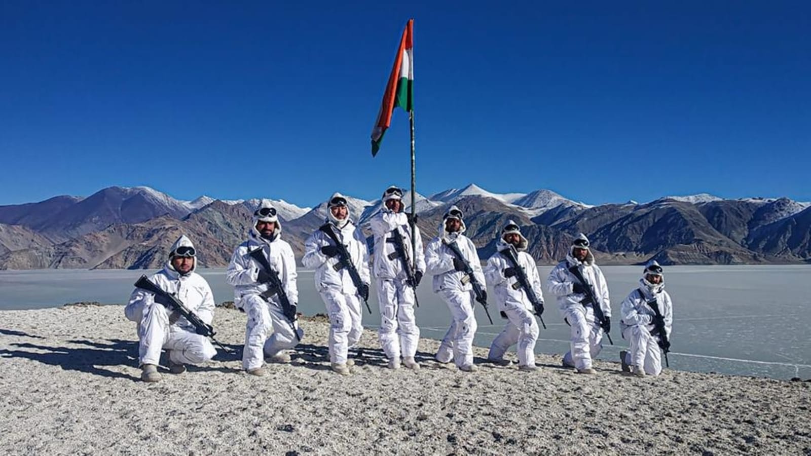
officers and soldiers of the Sino-Indian Border Task Force in defending the
country and bordering the country, which aroused public attention. In June 2020,
the Indian army illegally crossed the line, took the lead in provocation, and
violently attacked Chinese negotiators, deliberately creating conflicts in the
Kalwan Valley. After the conflict, China has maintained a high degree of
restraint in order to maintain the overall situation of the relations between
the two countries and the two militaries, promote the cooling and relaxation of
the situation. However, the Indian side has repeatedly hyped up the casualties,
distorted the truth, misled international public opinion, and slandered the
officers and soldiers of the Chinese border defense forces.
In June 2020, the Indian army illegally crossed the line, took the lead in
provocation, and violently attacked Chinese negotiators, deliberately creating
conflicts in the Kalwan Valley. ( Video screenshot) Today, the Chinese media has
announced the facts about the conflict in the Kalwan Valley, restored the brave
battle in Karakorum, and led people to the frontline of the frontier defense
struggle.
What is the working environment of border guards? Under what challenges are they
defending national sovereignty and territorial integrity? The following is a
detailed explanation of the real situation of the battlefield environment on the
Sino-Indian border. The border
stretches along the border, which is close to the mountains and rivers of the
motherland
. The Sino-Indian border stretches for more than 1,700 kilometers. Because the
two sides did not reach a consensus on the division of the border, some border
dispute areas have emerged. The disputed lines of the eastern section of the
China-India border mainly include: the traditional customary line of China and
India (the line we advocate), the illegal "McMahon Line" (the line that India
claims), the line of actual control, etc.; in the western and middle sections,
there are Sino-Indian lines. The traditional custom line (our side advocates the
line), the illegal "Johnson line (the Indian side advocates the line), the
actual control line.
The Karakoram Mountains in the Ngari region of Tibet. Figure|Visual China in
historyAbove, the border between China and India has long been roughly divided
by the Himalayas and Karakoram Mountains, forming a traditional customary line.
This was formed in the long history of peaceful and friendly coexistence between
the two peoples and within the scope of the jurisdiction of both parties.
The disputed area in the eastern section is located in the area south of the
"McMahon Line" and north of the traditional dividing line, that is, my country's
southern Tibet. It is under the jurisdiction of Cona County, Longzi County,
Medog County and Chayu County in Tibet, with a total area of more than 90,000
square meters. Kilometers. In addition, India has also put forward territorial
claims on many disputed areas and weakly controlled areas.
The disputed area in the middle section is located in the Ngari region of Tibet,
bordering India's Himachal Pradesh and Uttar Pradesh. There are 4 disputed areas
with a total area of about 2,650 square kilometers.
The disputed area in the western section is located in the Hotan area of
Xinjiang and the Ali area of Tibet, bordering the Indian-controlled Kashmir
area. There are 3 disputed areas with a total area of about 33,000 square
kilometers.
Border frictions and conflicts between China and India are mainly concentrated
in the passage area .
Due to the barrier between the Karakoram Mountains and the Himalayas, the land
transportation between China and India can only travel along the mountain
channel. There are more than 200 large and small passages along the
1,700-kilometer China-India border, most of which can only pass people, mules
and horses. Due to the strong seasonality of the climate, these passages are
impassable for most of the time due to snow, and only a few passages can pass
all year round.
Important passages in the eastern section include: *Cona-Tawang-Bundila-Tispur
passage This is the largest passage in the eastern section of the Sino-Indian
border, connecting our Tibet military town Zedang and the important Indian city
of Tispur. Cona-Bangshan is 48 kilometers long and is a simple road with poor
road conditions and difficulty in driving. Bangshankou-Tawang-Tispur is 389
kilometers long. It climbs over mountains and ridges along the way. In winter
and spring, the mountains are blocked by heavy snow and traffic is difficult.
The damaged road is not easy to repair. In the 1962 Sino-Indian border
self-defense counterattack, our army wiped out more than 7,000 Indian troops in
the area.
*Ranwu-Chayu Passage an important passway from Qamdo, Tibet to northeastern
India. It is a high mountain and canyon terrain with a total length of about 532
kilometers and a valley width of 100-500 meters. It is open in all seasons.
During the Sino-Indian border self-defense counterattack in 1962, our army wiped
out 1,256 Indian troops in the area and achieved the "Varong Victory".
*Sikkim Section Passage is located in Yadong County, Rigaze District, Tibet
Autonomous Region. It is the closest passage for Sikkim to Tibet. The mountains
are covered by heavy snow in winter and spring, and cars can pass through the
rest of the time . The passage is only tens of kilometers away from the Siliguri
Corridor, the strategic hub of India. If necessary, our army can quickly cut off
the Siliguri Corridor to isolate the Indian Northeast State Garrison. The
confrontation in Donglang in 2017 took place here.
The important passages in the middle section are: Shibuqi Pass Pass, Mana Pass
Pass and Uzala Pass Pass. Among them, the Shibqi Pass is the most important one.
It leads west to Simla, a military town in northern India, and east to Shiquan
River in the Ali region of my country.
Important passages in the western section include: Chipchap River Valley
Passage, an important passage between Indian-controlled Kashmir and the Aksai
Chin region of China. It is located in the uninhabited area of the Karakoram
Plateau in Hotan County, Xinjiang, with an average elevation of 5,300 meters. In
1962, China and India During the border self-defense counterattack, our army
cleared all of India's strongholds that crossed the traditional customary line.
The passage of the Qiangchenmo River Valley is an important passage between the
Keam Hot Springs and the Aksai Chin area, with an average elevation of 4,500
meters. The Kalwan River Valley incident in June 2020 occurred just north of the
channel.
The Mordor Passage is an important passway from the military town of Lehcheng to
Ritu County, Ngari Prefecture, Tibet, with an average elevation of 4,300 meters.
During the self-defense counterattack in 1962, our army had four victories and
four victories in the Pangong Lake area. It removed all 31 Indian strongholds
and successfully recovered Barrigas and Dimchuk.
Nagadong Passage is located in Dianjiao Village, Zhaxigang Township, Gar County,
Ngari Prefecture, with an average elevation of 4450 meters. This passage is the
main road from Leh to Shiquan River. If occupied, the Xin-Tibet Highway will be
seriously threatened.
Alpine mountains, test the troops' operations The battlefield environment is an
objective condition on which all military activities depend. It directly affects
the choice and application of both sides' combat styles, combat forces, and
combat methods, and restricts the process and outcome of combat.
The battlefield environment on the Sino-Indian border is an alpine mountainous
region, and the main characteristics are the "three highs"-high altitude, high
cold, and high hypoxia. The China-India border area mainly includes 3 types of
typical topography, namely the plateau wide valley area, the high mountain deep
valley area and the high mountain valley dense forest area .
*The plateau wide valley areas are mainly distributed in the western and middle
sections of the China-India border, with high altitude and wide valleys. The
average altitude is above 4000 meters, and some places can reach more than 6000
meters; the width of the valleys is generally above 1000 meters, and some even
reach Dozens of kilometers. The hills have small ups and downs, with an average
height of 300-400 meters. The valleys are relatively flat, mostly deserts and
meadows, but also rivers, lakes, and swamps. [Note: Average height, the average
height from the base of the feature or landform to the top. ] Heavy snow covers
the mountain from November to March of the following year, but the snow cover is
less than 1 meter, which has little impact on traffic. There are national
highways and county highways in the area, and the road conditions are good,
which is convenient for large forces to move and fight. The plateau and wide
valley area is not conducive to defense, but it is conducive to the attack of
armored mechanized troops. For example, the Dajila Pass in the middle section is
2000 meters wide and can pass through the pass all year round. Vehicles can also
drive off-road through the pass. In history, the enemy has used this pass to
invade our territory many times.
*High mountain and deep valley area is mainly distributed in the middle
section of the border and part of the eastern section, with high mountains, deep
valleys and narrow mouths. The average altitude is 4000-6000 meters, the terrain
is violently undulating, the mountain is steep, and the height difference is
large. It is a typical V-shaped valley; the average specific height is 1500-2000
meters, and some areas can reach 3000 meters; the valley bottom is generally
50-300 meters wide, and some The area is less than 10 meters, the slope on both
sides of the valley is about 50-70 degrees, and some are even close to upright.
Every winter and spring, the mountains are blocked by heavy snowfall. There are
fewer roads in the zone and fewer roads of operational value. Except for a few
national highways, most of them are simple roads and trails, winding and
winding, with a minimum radius of only 6 meters. Moreover, the longitudinal
slope of the road is large, some of which exceed 20%.Heavy equipment such as
tanks and artillery are difficult to maneuver. High mountains and deep valleys
are not conducive to offensive, large forces are difficult to move, and the use
of large-caliber artillery is limited, but it is conducive to defense. You can
build a defense system by using mountain ridges and narrow and dangerous
terrain.
*Alpine valley dense forest area is mainly distributed in the eastern part of
the border, with both high-altitude ice peaks and canyon abyss. The average
altitude is about 4000 meters. The slopes on both sides of the mountain pass are
steep and the terrain is steep; the water system is developed, the current is
turbulent, the bridge is difficult to build on the river, there are few bridges,
and flash floods are prone to occur in summer and autumn; the jungle is dense,
and some areas are dense virgin forests. There are only a few national highways
in this area, with narrow county and township roads, steep slopes and sharp
curves, and poor traffic capacity. The dense forest area in the mountains and
valleys is not conducive to the operation of large forces, and the use of
large-caliber artillery is limited, but it is conducive to small forces to
intersect and detour. During the Sino-Indian border self-defense counterattack,
our army inserted into the enemy's back from the "Pele Road" to cut off its
retreat. Generally speaking, the air in the alpine mountains is thin, with low
air pressure, low oxygen content, strong sunlight radiation, and strong wind;
when the altitude is above 5000 meters, the air density is about 60% of that of
the plain area, and the oxygen content is only 50% of that of the plain area.
%-60%, the weather is complex and changeable, the winter is long and cold, the
snow is thick, the temperature is low, the summer is hot, and the temperature
difference between morning and evening is large. This battlefield environment
will have a serious impact on personnel, weaponry, and troop operations. People
will experience altitude sickness to varying degrees when they first arrive in
the alpine mountains. Persisting here for a long time, people's vision, color
discrimination, hearing, memory, physical strength, endurance and thinking
ability will decline to varying degrees. People are susceptible to colds,
causing pulmonary edema, cerebral edema, high altitude heart disease, etc.
Strong sunlight can also cause dermatitis, skin burns and snow blindness, and
severe cold can easily cause frostbite accidents. According to estimates, in
areas with an altitude of 4,500 meters, human body functions are only about 50%
of that in low-altitude areas, and the speed of trekking is lower than that in
low-altitude areas by more than 60%. The impact of alpine mountains on weapons
and equipment is also very obvious.
A certain regiment of the Xinjiang Military Region organized an armored
detachment to carry out mobile coordinated training under severe cold
conditions. Figure | Xinhua News Agency At an altitude of 4,000 meters, the
range and accuracy of artillery and missiles will decrease, and the warheads
will fly high, remote, and spread widely . Strong winds on the plateau can also
easily cause trajectory deviation, which directly affects the accuracy of
artillery shooting and the burning degree and speed of the propellant charge.
Light weapons are prone to malfunctions such as jamming, non-continuous firing,
and reduced shooting accuracy. Hypoxia will reduce the power of vehicles and
weapon platforms by about 30%, increase fuel consumption by 30%-40%, reduce
driving speed by 40%-50%, reduce load by 10%-20%, and increase the failure rate
of equipment by 15-25 percentage point. The alpine mountain environment also
affects the performance of information equipment. The acquisition and
transmission of electromagnetic waves are seriously attenuated, the propagation
distance is shortened by 40%-70%, and the blind area is increased. In addition,
bad weather conditions will destroy the ionosphere, seriously hinder and
interfere with the propagation of electromagnetic waves, increase the failure
rate of electronic information equipment, and reduce the service life. It can be
seen that the alpine mountains have brought severe challenges to the operations
of the troops: First, it is restricted in many ways . The combat area, the size
of the force, the use of equipment, the mobility of the troops, and the
coordination of command and other aspects are restricted. For example, in the
eastern section, only mountain troops with divisions and brigades can be
deployed, and the use of heavy equipment such as large-caliber artillery and
tanks is restricted.
Second, the combat effectiveness of the troops has been significantly reduced .
Cold and oxygen will result in greatly reduced the effectiveness of physical
strength and weaponry, aviation troops, mechanized use is restricted.
The third is the difficulty of logistics support . The Sino-Indian border is far
from our strategic rear, and supplies are scarce. A large number of war
materials need to be transported from long distances. In addition, there are few
mountain roads, long distances, and poor road conditions, which greatly
increases the difficulty of logistics support.
Chen Bing tens of thousands, what does India want to do? The Sino-Indian border
is an important strategic direction of the Indian army. Under the strategic
guidance of “Protecting East, Stabilizing China, and Seizing the West”, India
will deploy 20% of its military forces on the Sino-Indian border and 30% of its
forces as a reserve team. Strategic depth zone.
*Eastern force deployment The eastern section of the China-India border is the
focus of the deployment of the Indian army. Among them, the deployment of troops
in Tawang direction of about 8.5 million people, including army a military (4th
Army stationed in Tezpur); three division headquarters, which Chayu channel
deployment step 2 Mountain Division, Cona channel deployment mountain stage 5
divisions; 14 brigades, about 55,000 people. Paramilitary forces and armed
police deployed 12 battalions, about 1.5 million people. The Air Force deploys 5
flying wings with approximately 15,000 people, stationed at 5 airports in
Chohat, Tispur, Chabuya, Gaohaiti, and Mohanbari, equipped with 21 Su-30MKI, 33
transport aircraft, and 36 aircraft. Helicopters are responsible for air
operations in the area and support ground operations. The Sikkim section has
approximately 64,000 troops, including 1 army headquarters (33rd Army in
Sukhna); 3 divisions (Shanbu 17th Division in Gangtok, Shanbu 20th Division in
Binaguri, and Shanbu 27 The division is based in Kalimpong), and the 17th and
27th divisions of Shanbu are deployed in the Nathula Pass; 14 brigades with
approximately 55,000 people. Paramilitary forces and armed police deployed 3
battalions. The Air Force deploys 2 wings with approximately 6,000 personnel.
The 16th Wing is stationed in Hasimara and the 20th Wing is stationed in Bagh
Dougla. It has 30 fighters (MiG-21) and 39 fighter-bombers (MiG- 27), 10
helicopters.
*The middle and western sections are deployed in the western section. The Indian
army deploys 35,000 troops, including 1 army headquarters (14th Corps stationed
in Leh); 2 divisions (mountain 8th division stationed in Awangtipur, 3 infantry
The division is stationed in Karp), with about 25,000 people, focusing on the
defense of the Kazan Pass; 10 battalions of paramilitary forces with nearly
10,000 people, and guarding the west and north directions. The Air Force
deployed the 21st Flying Wing (based in Leh) and 2 helicopter squadrons,
equipped with 20 Mi-8 and "Cheetah" helicopters; the 19th forward base support
unit (Toishi), with 23 helicopters, 5 meters Grid-29.
The Indian army deployed about 38,000 troops in the middle section, including 1
army division (Shanbu 6th Division in Bareilly); 5 brigade divisions, focusing
on the defense of the Qiangla Pass; 12 paramilitary battalions, about 12,000
people. The Air Force deploys 2 flying wings, stationed at 2 airports in
Bareilly and Gorakpur, with 35 Su-30MKI, 36 multi-role fighters, and 17
helicopters.
The deployment of troops is a direct reflection of combat thinking. In terms of
military deployment, India emphasizes "offensive deployment" and has established
a deployment policy of "consolidating first-line forces, strengthening
second-line reserve forces, expanding the depth of the battle, and enhancing
defense flexibility" to demonstrate its territorial ambitions.
The main features of the Indian army's deployment include: *Strong purposeful
deployment of forces. The Indian army believes that the eastern section is
"the most vulnerable direction" and the Sikkim section is "the most sensitive
part of Indian defense." Therefore, the focus of its deployment is on the
eastern section and the Sikkim section, where 70% of the troops in the
Sino-Indian border area are deployed.
*Large defense depth The Indian Army is deployed in 3 echelons in the border
area to increase its defense flexibility. The first echelon is mainly stationed
by paramilitary forces at a distance of 10-20 kilometers from the actual control
line; the second echelon is guarded by brigade and battalion units at a distance
of 50-100 kilometers from the actual control line, constituting the main
defensive zone; The 100-300 km section of the control line is held by the main
forces of the army, division, and brigade, forming a defense-in-depth zone, and
is equipped with powerful air combat forces and ground air defense forces.
* Give full play to the strengths of the mountain troops. The Indian Army
deployed mountain infantry divisions as far as possible according to the combat
characteristics of the alpine mountains. Among the 8 infantry divisions
deployed, the mountain infantry divisions account for 7; of the 38 brigades,
mountain brigades and mountain artillery brigades account for 30. Mountain
infantry divisions are equipped with helicopter detachments and artillery
adapted to mountain combat in order to better exert their expertise.
*Front light and heavy In order to reduce the garrison of military strongholds
in the forward areas and reduce the burden of logistical support, the Indian
army has adopted a policy of lightly deploying front-line and heavy-duty
deployments, and dispatched troops to military strongholds in front-line
sensitive areas to demonstrate sovereignty. Deploy forces with strong resistance
to shallow and deep areas to enhance their defense capabilities. Deploy an
offensive force with strong firepower and mobility to the deep area. Once there
is a situation, it can quickly go forward to support frontline operations.
The ambition for hegemony hides it.
In the past 70 years of independence, India has repeatedly provoked neighboring
countries in pursuit of its “hegemony” status in the South Asian subcontinent.
After the Gulf War, the Indian army learned from the experience of the US
military's "information warfare + firepower warfare" and explored joint
operations in alpine mountains and formed combat characteristics with its own
characteristics in practice.
The first is to give play to air superiority and combine air and ground
operations. Due to limited ground mobility in mountain operations, the Indian
army gave full play to its air superiority and carried out joint air-to-ground
operations. To remove obstacles for ground operations, the general army can be
supported by 3-4 flying wings and 100-350 sorties of fighters, and
military-level operations can be supported by 2-3 flying wings and 30-80
sorties. Combat can be supported by 1-2 flying wing and 10-30 sorties of
fighters, and brigade-level combat can be supported by 1 flying squadron. Focus
on attacking the frontier and the opponent's shallow, near and deep important
targets to remove obstacles for ground operations; use air power to block the
battlefield and cut off the front and back contacts of the opponent to create
conditions for ground operations; implement in-depth assaults and use air power
to focus on attacking the opponent's border area airports, ammunition materials
warehouses, command center, heavily Group, the main transportation lines,
traffic hubs to reduce ground combat stress.
The second is to attach importance to information warfare. The Indian Army
regards information warfare as a "force multiplier," not only equipped with a
large number of information warfare equipment, but also closely combining "soft
kill" and "hard destruction" as the main means to achieve combat goals. In
recent years, the Indian army has used drones more and more frequently, often
sending drones to reconnaissance.
The third is the depth of defense operations. The Indian army relied on terrain
and positions to organize defenses, steadily blocked, consumed a large amount of
the opponent's active force, and constantly attacked the opponent's follow-up
troops, logistics supply lines, and shallow and deep targets. For some special
terrain areas, the Indian army has adopted a front-line defense that is heavy
and light.
The fourth is to attach importance to night operations. Most of the Indian
army’s main battle equipment and ground troops are equipped with night vision
equipment. They are good at night offensives, carry out aerial assaults, ground
penetration, and airborne behind enemy lines, and work closely with frontal
attacks to capture predetermined targets.
Fifth, he is well versed in the way of fighting in alpine mountains. After 1962,
the Indian Army focused on learning from the experience and lessons of combat in
alpine mountains. Over the past decades, it has continuously tempered in actual
combat in alpine mountains, flexibly using firepower warfare, air-to-ground
combat, information warfare, logistics support and counter-support and other
tactics and practical experience. Not to be underestimated. In addition to
paying attention to absorbing the combat experience of the Soviet Union, the
United States and other countries, India has also spared no expense in
purchasing a large number of advanced weapons from abroad, striving to be
superior in quantity and quality. Most of India’s light weapons are produced in
the country, while heavy weapons are mostly purchased, imitated or jointly
produced from abroad.
The main battle equipment of the Indian army includes field artillery, tanks and
armored vehicles, anti-tank missiles, anti-aircraft missiles and combat aircraft
. The Indian Army Mountain Infantry Division governs 3 mountain infantry
brigades and 1 artillery brigade. Each mountain infantry brigade is equipped
with 66 artillery pieces, and the artillery brigade is equipped with 84
artillery pieces. There are about 282 artillery pieces in the whole division;
the infantry division has 3 infantry brigades. 1 artillery brigade, each
infantry brigade equipped with 78 artillery, artillery brigade equipped with 84
artillery, a total of about 318 artillery in the division. In addition, the
American AN/TPQ-37 long-range anti-artillery weapon positioning radar has been
introduced, which can effectively improve the artillery’s rapid reaction
capability. The Indian Armored Division administers 3 armored brigades and 1
artillery brigade, with a total of 367 tanks, 295 armored vehicles, and 188
artillery pieces. Tanks include T90, T-72M1, "Arjun" and the old "Victor" and
other models; armored vehicles are mainly BMP-1 infantry fighting vehicles, BMP2
armored transport vehicles and BRDM2 armored reconnaissance vehicles, all of
which are purchased or copied Soviet-style equipment is only equivalent to the
level of the 1970s and 1980s. The Indian Infantry Division and Shan Infantry
Division are equipped with anti-tank missile companies, equipped with 15 missile
launchers and 150 missiles. BMP-1 infantry fighting vehicles, BRDM-2 armored
reconnaissance vehicles and attack helicopters are all equipped with anti-tank
missiles. In terms of air defense systems, the Indian army mainly has 6 types
and about 15 air defense radars in the Sino-Indian border area, including
THD-1955, PSM-33, "Indra" II and other models, and the detection range of air
targets is about 220- 290 kilometers. In the east section and the direction of
Sikkim, the actual control line can be detected within a range of 50-100
kilometers on our side; in the middle and west sections, it can detect targets
close to the actual control line, and it is equipped with multiple air defense
missiles. The Indian army has deployed 10 flying wings along the border, with
about 320 combat aircraft of various types. The main fighters include Su-30MKI,
MiG-29, MiG-27, MiG-23, MiG-21, Mirage-2000, "Jaguar", etc.; helicopters include
AH-64E, Mi-25, Mi- 35. Mi-17, "Cheetah", etc. In addition, 3 A-50 early warning
aircraft and 8 P-8I patrol aircraft were deployed. P-8Is were even dispatched to
the Kalwan Valley area for reconnaissance and strengthened surveillance of
border areas to make up for the lack of early warning capabilities of the Indian
Air Force.
China and India have established diplomatic relations for more than 70 years.
The relations between the two countries have gone through ups and downs over the
years, and it has not been easy to achieve today's development.
China’s position on resolving the Sino-Indian border issue is clear and
consistent. We are always committed to properly resolving disputes through
dialogue and maintaining peace and stability in the border area . It is hoped
that the Indian side and China will work together to maintain the peace and
tranquility of the China-India border area and promote the long-term, healthy
and stable development of bilateral relations. This is in the common interests
of the two peoples.