bennedose
Senior Member
- Joined
- Jun 21, 2013
- Messages
- 1,365
- Likes
- 2,169
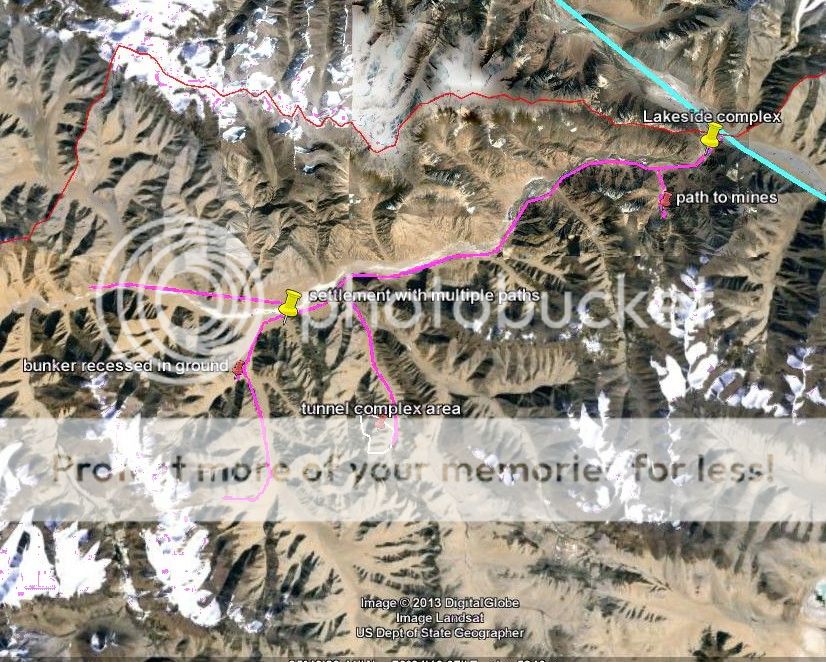
So far I have concentrated on the northern part of the LAC in north west Aksai Chin near DBO.
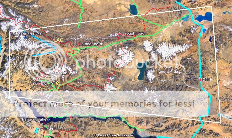
Next I will move to the south-west area of the LAC to the Chushul area. The Chushul area differs from the northern parts near DBO in three significant ways. First, Chinese logiistics lines are somewhat shorter - the two main roads to the area are 120 and 150 km long (as per my measurements that straighten out minute road curves). Secondly, the roads do not run through Aksai Chin as they do in the north but in westen Tibet. Thrid, and possibly most significant is the fact that the area, and the access roads themselves are 800 meters to 1000 meters lower in altitude than Aksai Chin. For this reason there are human settlements along the roads - although some of them clearly look like "planned" Chinese settlements brought in by the PLA rather than indigenous Tibetan villages. there is some vegetation and there are farmlands, hay and green farm plots visible.
The condition of the roads themselves appears to be somewhat better than the roads in Aksai Chin, but here again long stretches still appear "kaccha" and simply cross rivers without any sign of bridges or other construction work.
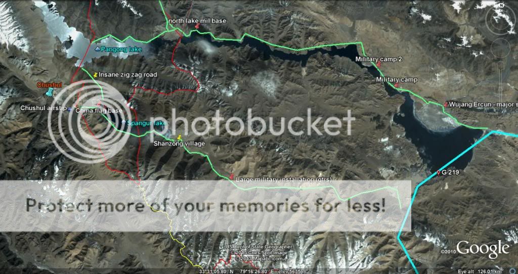
The area near the LAC close to Chushul saw some of the fiercest battles in 1962. The two roughly parallel green coloured roads are the two main Chinese roads leading to the rergion from the main G 219 highway (in blue). These two roads are like two brackets that exactly enclose the geography in the region. At the LAC there are two long (not oval) east-west lakes. The northern lake is the longer one and is called Pangong lake. (blue letters in map)The western reaches of Pangong lake are under Indian control. The more northen one of the two Chinese roads runs on the north shore of Pangong lake and ends at the LAC.
About 15-20 km south of Pangong lake is another lake called the Spangur lake (again in blue letters in the map below). The second Chinese road is on the south shore of this lake. The area between the two lakes is mountainous and there appear to be no visible lakeside roads along the narrow strip of land between the two lakes. There is however one road that I have labelled as "Insane zig-zag road" that leads from the north shore of Spangur lake (the southern lake) to the south shore area of Pangong lake (the northern lake). This road has about 106 hairpin bends over a length of about 6 km and the road itself must be 20 or 30 km long over this segment.
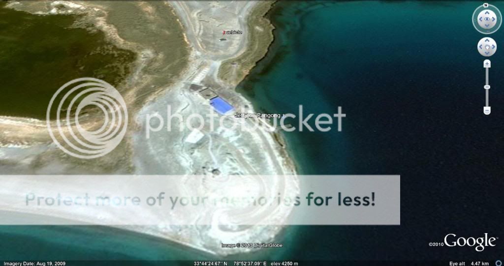
Surprisingly I was able to spot no boats or wakes of boats or jetties with boats anywhere on these lakes.
All these features can be examined using the kmz file linked below.
About half of the southern lake, Spangur lake was under Indian control in 1962, but the border was pushed back up to the current LAC which is at the western end of Spangur lake. Chushul lies in this area, which is to the west of the end of spangur lake and south of Panging lake. There appears to be an unpaved airstrip just to the west of Spangur lake and I suspect this is the now unused Indian airstrip at Chushul.
I post the overview map below along with the Google earth kmz file. I will post details I have found and my comments in later posts
kmz file: https://docs.google.com/file/d/0B3J...0B3JNY4IY8u2bTjUyak9KajN5WFU/edit?usp=sharing
Overview image- click on image to see original
Next I will move to the south-west area of the LAC to the Chushul area. The Chushul area differs from the northern parts near DBO in three significant ways. First, Chinese logiistics lines are somewhat shorter - the two main roads to the area are 120 and 150 km long (as per my measurements that straighten out minute road curves). Secondly, the roads do not run through Aksai Chin as they do in the north but in westen Tibet. Thrid, and possibly most significant is the fact that the area, and the access roads themselves are 800 meters to 1000 meters lower in altitude than Aksai Chin. For this reason there are human settlements along the roads - although some of them clearly look like "planned" Chinese settlements brought in by the PLA rather than indigenous Tibetan villages. there is some vegetation and there are farmlands, hay and green farm plots visible.
The condition of the roads themselves appears to be somewhat better than the roads in Aksai Chin, but here again long stretches still appear "kaccha" and simply cross rivers without any sign of bridges or other construction work.
The area near the LAC close to Chushul saw some of the fiercest battles in 1962. The two roughly parallel green coloured roads are the two main Chinese roads leading to the rergion from the main G 219 highway (in blue). These two roads are like two brackets that exactly enclose the geography in the region. At the LAC there are two long (not oval) east-west lakes. The northern lake is the longer one and is called Pangong lake. (blue letters in map)The western reaches of Pangong lake are under Indian control. The more northen one of the two Chinese roads runs on the north shore of Pangong lake and ends at the LAC.
About 15-20 km south of Pangong lake is another lake called the Spangur lake (again in blue letters in the map below). The second Chinese road is on the south shore of this lake. The area between the two lakes is mountainous and there appear to be no visible lakeside roads along the narrow strip of land between the two lakes. There is however one road that I have labelled as "Insane zig-zag road" that leads from the north shore of Spangur lake (the southern lake) to the south shore area of Pangong lake (the northern lake). This road has about 106 hairpin bends over a length of about 6 km and the road itself must be 20 or 30 km long over this segment.
Surprisingly I was able to spot no boats or wakes of boats or jetties with boats anywhere on these lakes.
All these features can be examined using the kmz file linked below.
About half of the southern lake, Spangur lake was under Indian control in 1962, but the border was pushed back up to the current LAC which is at the western end of Spangur lake. Chushul lies in this area, which is to the west of the end of spangur lake and south of Panging lake. There appears to be an unpaved airstrip just to the west of Spangur lake and I suspect this is the now unused Indian airstrip at Chushul.
I post the overview map below along with the Google earth kmz file. I will post details I have found and my comments in later posts
kmz file: https://docs.google.com/file/d/0B3J...0B3JNY4IY8u2bTjUyak9KajN5WFU/edit?usp=sharing
Overview image- click on image to see original

Last edited: