Tonnage Through Tibet
SECRET
A methodology for assessing highway logistics applied in the Chinese Communist attack on India.
TONNAGE THROUGH TIBET
Philip Vetterling and Avis Waring
A more than routine interest has recently been focused on problems of highway logistics by the Communist Chinese threat along the northeastern border of India. The magnitude of this threat depends in large part on the Chinese ability to move military supplies by road from railheads deep in China to the areas of conflict; air transport, the only alternative, is at present not available to the Chinese in significant capacity. It was therefore possible to make an estimate of the threat, in terms of the size of the military forces that could be supplied, by computing the capacity of the roads, setting this against the supply requirements of the forces actually in Tibet, and so determining what excess capacity was available to support additional troops in operations against India. Two other possibly limiting factors had also to be calculated - the number of trucks needed to move the supplies, and the amount of petroleum required to fuel the trucks. The methodology for these calculations, described in the following pages, can be used to estimate the size of military force that can be supported in other campaigns dependent on supply by road.
Roads to the World's Roof
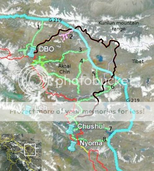
The Chinese forces at the front lines on the Indian border were at the end of roads that wind 700 to 1,800 miles over high and rugged terrain. The three main access routes to Tibet are indicated on the accompanying map. The most important of these is the Tsinghai-Tibet highway running south from Golmo to Lhasa. Golmo can be reached by road either from the railhead in the vicinity of Hsia-tung on the transSinkiang railroad or from that at Hsi-ning west of Lan-chou.
The major route for the movement of supplies appeared to be the former, from the Hsia-tung area southward through Golmo for about 1,000 miles to An-to or 1,300 miles to Lhasa. The average elevation of this road from Golmo on is about 14,000 feet. Troops along the western border of the North East Frontier Agency, those in the Chumbi Valley Opposite Sikkim, and those located as far west as the southern part of Ladakh were supplied by this route.
The other two routes, supplying the extreme flanks, are about equal in importance to each other. The SzechwanTibet highway, running west from the railhead at Ch'eng-tu in Szechwan Province, served the troops in the Ch'ang-tu area and the eastern border of NEFA. It goes on from there to Lhasa, a total distance from Ch'eng-tu of about 1,200 miles, over extremely rugged terrain ranging to 12,000 feet in elevation. The third route runs from the railhead in the Urumchi area in northwestern China southwest to Kashgar, then southeast to the Ladakh area. From Urumchi to Rudog it covers about 1,340 miles at elevations ranging from 3,500 feet in the northern portions to between 11,000 and 16,000 feet in the south.
The combined practical forward capacity of these access routes under ideal conditions was figured at 2,000 short tons per day-1,000 tons delivered to Lhasa via Golmo on the Tsinghai-Tibet highway, 500 tons delivered to Ch'ang-tu from Szechwan for the eastern flank, and 500 tons delivered over the Kashgar-Rudog road for the Ladakh front. These main access routes are supplemented by roads leading forward to the frontier and subsidiary east-west and north-south routes to a total of some 7,500 miles.
Development of a Methodology
By the mid-1950's policy makers as well as transportation intelligence specialists had become greatly concerned about the wide divergence in estimates of the capacities of identical transportation routes and facilities published in supposedly definitive U.S. and UK intelligence reports. These estimates were important to policy makers as a basis for determining the size of enemy forces that could be deployed and supported in various areas of the world. Without a common understanding of the factors which entered into the calculation of the capacities of the various forms of transportation, however, it had been impossible for the specialists who made the estimates to arrive at reasonably uniform conclusions. The disparities confused and irritated the policy makers.
As a consequence, the Subcommittee on Transportation of the Economic Intelligence Committee, composed of transportation specialists of the U.S. community, undertook a series of studies which led to the formulation of methodologies for estimating the capabilities of railroads, roads, ports, and inland waterways.1 These were then sent to the XXXX XXXXX XXXX XXXXX XXXXX XXX to get its views. After much consultation and exchange of correspondence, working-level agreement on the method for computing railroad capacity was reached in 1960 and on that for computing road capacity in 1961. These methods were subsequently approved by the logistics specialists who provide intelligence support for SHAPE and are now widely used by the intelligence components of NATO countries.
In the U.S. government the task of estimating road capacities for intelligence purposes is performed primarily by the intelligence components of the Department of Defense. The estimate of 2,000 tons as the capacity of the major supply routes into Tibet was made originally by DOD analysts by these now standard methods and accepted by other components of the intelligence community. The process is described in brief below.
One begins with the ideal capacity of a road of a given type of surface in perfect condition and good weather, straight, and without traffic hindrances. On paved roads 5-ton trucks are assumed to move at 25 miles per hour spaced 300 feet apart to allow for the "concertina" (compression wave) action inherent in any continuous truck convoy operation. On unpaved roads the dust hazard requires increased spacing and decreased speed. A simple calculation gives the number of trucks that can be moved in both directions during a 24-hour period, considering only the speed, interval between vehicles, and type of surface.
This basic capacity is then reduced to obtain what is known as operational capacity, which makes allowance for the constraints imposed by driver inefficiency, vehicle casualties, essential maintenance enroute, and unforeseen operational developments. These contingencies are estimated to reduce the basic capacity by 20 percent. A practical capacity is obtained by applying further reduction factors to the operational capacity to take into account the following:
Less than ideal road characteristics;
Turning and crossing operations, including delays caused by convoys entering and leaving the highway and the movement across the highway of other essential traffic, civilian and military;
Operational phasing, including the constraints created by administrative and civilian vehicles, stops for meals, refueling, driver rest periods, and the reduced efficiency of night operations.
The resulting practical capacity is expressed in vehicles per day traveling in both directions. Multiplication by the net load per truck, in this case 3 tons, gives the daily tonnage in both directions, and half of this is the practical forward capacity of the road in tons per day.
The value of the several reduction factors has been derived from engineering data on highway transportation and capacity, taking into account vehicle performance and road design, construction, and maintenance. Where precise data were not available on certain types of roads, the experience of highway transport specialists and engineers in truck convoy operations was consulted in assigning values.
In formula form the calculation looks like this:
B = 0.8A
C = B-a-b-c-d-e-f
D = gC
E = D/2
Where:
A = basic capacity (vehicles per day)
a = surface width reduction factor
b = shoulder width reduction factor
B = operational capacity (vehicle per day)
c = curves and gradient factor
C = practical capacity (vehicles per day)
d = surface deterioration and maintenance factor
D = practical capacity (tons per day)
e = factor for turning and crossing movements
E = practical forward capacity (tons per day)
f = operational phasing factor
g = load per truck in tons
Capacity to Tibet
The derivation of the capacity of the Tsinghai-Tibet and Szechwan-Tibet highways will illustrate the application of this methodology. The surface of the Tsinghai-Tibet highway from Golmo to Lhasa is given as crushed rock and gravel with some earth sections. The basic capacity of such a surface is 8,400 and the operational capacity 6,700 5-ton trucks per day. The reduction factors are as follows:
Symbol Characteristic Description Reduction Factor
a Surface width 30 feet 1.0
b Shoulder width Less than 3 feet 0.8
c Curves and gradient Over 7 percent 0.6
d Surface condition Fair with most subsoil 0.5
e Turning and crossing movements 0.85
f Operational phasing 0.5
g Load per truck 3 tons
The practical capacity is then 6,700 X 1.0 X 0.8 X 0.6 X 0.5 X 0.85 X0.5 = 683 vehicles, carrying, at an average load of 3 tons, 2,049 tons per day in both directions. Halving this gives a practical forward capacity of 1,025 tons, which may be rounded to 1,000 tons per day.
The surface of the Szechwan-Tibet highway from Ch'eng-tu to Lhasa via Ch'ang-tu is given as crushed rock, gravel, and sand, this also having an operational capacity of 6,700 vehicles per day. But the reduction for surface width and condition is greater:
Symbol Characteristic Description Reduction Factor
a Surface width 12 to18 feet 0.6
b Shoulder width Less than 3 feet 0.8
c Curves and gradient Over 7 percent 0.6
d Surface condition Fair to poor, with most subsoil 0.4
e Turning and crossing movements 0.85
f Operational phasing 0.5
g Load per truck 3 tons
1 For a detailed explanation of these methodologies, see Department of the Army Field Manual FM 55-8, Transportation Intelligence, December 1961.
SECRET
Historical Document
Posted: May 08, 2007 07:46 AM
Last Updated: Aug 04, 2011 03:04 PM
Last Reviewed: May 29, 2008 01:48 PM
https://www.cia.gov/library/center-...ence/kent-csi/vol7no2/html/v07i2a02p_0001.htm
**************************
A backgrounder.
China has large warehouses at strategic locations, where food essentials are stocked, ostensibly for the civil population, but actually for the military and the increments during active combat.