Never heard of SAR (synthetic aperture radar)?Maybe.
I am interested in specifics though. The paragraph is pretty much vague.
Let me explain why, but before that, it would help if you read about the U-2 Incident.
Long story short, the U-2 plane, which was a high altitude spy aircraft, was to fly over the USSR and take photographs. On occasions, these flights had to be delayed due to bad weather. Now, high altitude aircraft won't have a problem flying over the clouds. It would have problems photographing the surface.
Now, coming to satellite imagery, how can we actively monitor the Himalayas or the Karakoram, if there are clouds? Is it possible to have FLIR type imaging devices on satellites that will also be accurate and free from distortion? I have my doubts.
That is why I am interested in more details. Now, given the amount of secrecy in this programme, I am not expecting a lot of details.

Pakistani Space Program news & updates
- Thread starter Indx TechStyle
- Start date
More options
Who Replied?pmaitra
Senior Member
- Joined
- Mar 10, 2009
- Messages
- 33,262
- Likes
- 19,594
Never heard about it.Never heard of SAR (synthetic aperture radar)?
Welcome to the forum.
SAR will not cover human movements, read carefully what he meant.Never heard of SAR (synthetic aperture radar)?
- Joined
- Apr 29, 2015
- Messages
- 18,286
- Likes
- 56,238
Quarrying at Margallas: Govt counsel fails to submit satellite images

The provincial government has also objected to the maintainability of the applications of stone crushers against the ban on their activities. PHOTO: APP

The provincial government has also objected to the maintainability of the applications of stone crushers against the ban on their activities. PHOTO: APP
ISLAMABAD: As the top court of the country is resuming the hearing of a suo motu case regarding the illegal activities at Margalla Hills today (Wednesday), the federal government has failed to produce the satellite images of the area.
Additional Attorney-General (AAG) Waqar Rana has submitted a statement in the Supreme Court wherein it is stated that the government has no satellite images of the area. He, however, said that a request had been made to Pakistan Space and Upper Atmosphere Research Commission (Suparco), the only organisation which has the technology to take satellite images of the area.
The research body officials, however, in their statement, said that images of the area comprising the Margalla Hills National Park for 2013 had already been procured.
However, the images for 2016 will be obtained from abroad, pending the payment of fee that will be charged at a rate of 10 euros per square kilometre.
“A request for obtaining imagery of 2016 has been sent to Suparco and to arrange the requisite funds, a letter has been written to law ministry”, the AAG said.
The statement says that the response of Suparco and the law ministry is awaited and once the latest imagery is received, same shall be placed on record. Meanwhile, the Punjab government has told the SC that the police officials have been deployed at the Margalla Hills to stop the illegal activities of quarrying.
Couldn't get any positive news about their agency. And this news either isn't completely regarding suparco. It's a legal issue where their agency was cited.The provincial government has also objected to the maintainability of the applications of stone crushers against the ban on their activities.
- Joined
- Apr 29, 2015
- Messages
- 18,286
- Likes
- 56,238
So, finally they did.
Quarrying in the hills: Govt counsel submits 10 images of Margallas

Suparco extended all possible cooperation within a short span of time, which is highly appreciated and acknowledged, he said. PHOTO: APP
Quarrying in the hills: Govt counsel submits 10 images of Margallas
Suparco extended all possible cooperation within a short span of time, which is highly appreciated and acknowledged, he said. PHOTO: APP
ISLAMABAD: The top court has directed the federal, Punjab and Khyber-Pakhtunkhwa (K-P) governments for the fresh demarcation of the Margalla Hills National Park in view of the satellite images of the area.
The two judge bench, headed by Chief Justice Anwar Zaheer Jamali ordered the federal government to produce complete 40 satellite images of the area for 2016 on the next date of hearing.
During the hearing, Additional Attorney General (AAG) Muhammad Waqar Rana produced 10 satellite images of the area for 2016.
The Pakistan Space and Upper Atmosphere Research Commission (Suparco) is the only organisation, which has the technology to take satellite images of the Margalla Hills National Park area.
During the hearing, the bench observed that 80 per cent stone crushing is taking place illegally.
The top court bench however accepted the petitions of stone crushers for regular hearing.
The hearing of case was adjourned till the first week of August.
Later, AAG Waqar Rana clarified that Suparco provided the images free of cost.
@KyubiSuparco extended all possible cooperation within a short span of time, which is highly appreciated and acknowledged, he said.
- Joined
- Apr 29, 2015
- Messages
- 18,286
- Likes
- 56,238
Suparco to launch own satellite to replace Google Earth
SUPARCO is launching its own Remote Sensing Satellite to replace Google Earth through which a local search engine "Akas-e-Pakistan" will also be operated.
This was revealed by Deputy Chairperson Space & Upper Atmosphere Research Commission (SUPARCO) Dr Arifa Lodhi during a meeting with Additional Chief Secretary Punjab Shamail Ahmad Khawaja here on Sunday.
She said "Akas-e-Pakistan" will replace Goggle Earth and our own institutions will be enabled to utilise the most accurate geological information through enhanced high-resolution satellite imageries free of cost.
SUPARCO is using PAKSAT-ONE IRA through SPOT Space Station of France which costs millions of dollars per annum, she added.
SUPARCO Pakistan and the Government of Punjab will collaborate in the use of space technology applications to accelerate the economic growth process along with exploration of minerals and preparation of forests inventory in the province.
SUPARCO management assured that the Punjab Government with the collaboration of SUPARCO and Punjab Information Technology Board (PITB), will arrange training sessions of the relevant provincial officers of those departments to benefit from the space technology.
He emphasised the need for preparing forests inventory in Punjab besides establishing GIS Laboratories in the provincial departments for Crops Reporting System soil crop condition assessment, mapping of crop land characteristics, forest mapping, flood mapping, resource mapping, crime mapping, infra structure development and health management, identification of contaminant levels in the industrial areas, identification of encroachment in beds of the rivers and exploration of mines and minerals etc.
HariPrasad-1
Senior Member
- Joined
- Jan 7, 2016
- Messages
- 9,611
- Likes
- 21,080
Zaid hamid said in 2008 that withing next 5 years pakistan shall reach moon. All important decision in the world shall be taken after the consultation with Pakistan.And they already reached the moon because it is on their flag.
That did not happen but porkistan became a failed state in that period. Porkistan is in regression and self destruction mode. You can not expect anything good from them.
anoop_mig25
Senior Member
- Joined
- Aug 17, 2009
- Messages
- 5,804
- Likes
- 3,151
why are they launching in first place.they can always use chinese one in first place
why waste money instead transfer it to pk army
- Joined
- Mar 22, 2016
- Messages
- 1,394
- Likes
- 3,097
The P is for Pork. They were confused between "SuperPork" and "SuarCo", so they did both.Why is there a P in SUPARCO ?
_________________
Blackwater
Senior Member
- Joined
- Jan 9, 2012
- Messages
- 21,156
- Likes
- 12,211
Why is there a P in SUPARCO ?
_________________
P for ....Phuddu
which every paki is
:bounce::bounce::bounce::bounce:
mayfair
Senior Member
- Joined
- Feb 26, 2010
- Messages
- 6,032
- Likes
- 13,109
If you are self-proclaimed "Citadel of Islam", would you name your Space agency SUARCO?Why is there a P in SUPARCO ?
Then there is PISS and RANDI.
What does all this tell us?
That BAKI concept of awareness is highly contextual.
- Joined
- Apr 29, 2015
- Messages
- 18,286
- Likes
- 56,238
REMOTE SENSING SATELLITE TO BE LAUNCHED IN MARCH 2018: SUPARCO
Chairman Suparco says this satellite will further enhance country's capability in space science.

Chairman Suparco says this satellite will further enhance country's capability in space science.
Pakistan is striving to deepen space related cooperation with its time tested and old friend China.
This was stated by the Chairman, Pakistan Space and Upper Atmosphere Research Commission (Suparco), Qaiser Anees Khurram in an interview with our correspondent Zahid Hameed.
The Chairman Suparco said that the first communication satellite Paksat-1R was developed and launched in cooperation with Chinese friends. Now we are developing the first-ever remote sensing satellite with the Chinese cooperation, which will be launched in March 2018. He said the launch of this satellite will further enhance the country's capability in space science. This satellite will also help Pakistan in its national security matters and enhance its surveillance capabilities.
http://www.radio.gov.pk/24-Sep-2016/remote-sensing-satellite-to-be-launched-in-march-2018-suparcoQaiser Anees said both the countries are also working in several other space related projects and expressed the confidence that the country will stand on strong footing in terms of space technology and applications in the next four to five years.
Did she mean replacing Google Earth with one satellite??? If so, kindly move it to relevant thread.
And why anything pertaining to Pakistan and its development is always like Govt of Pakistan and Punjab? Seems they have nothing else then Punjab and CPEC in their developmental agenda.
Blackwater
Senior Member
- Joined
- Jan 9, 2012
- Messages
- 21,156
- Likes
- 12,211
Suparco to launch own satellite to replace Google Earth


:biggrin2::biggrin2::biggrin2::biggrin2::biggrin2::biggrin2::biggrin2::biggrin2:
:biggrin2::biggrin2::biggrin2::biggrin2::biggrin2::biggrin2::biggrin2::biggrin2:
- Joined
- Apr 29, 2015
- Messages
- 18,286
- Likes
- 56,238
Pakistan Remote Sensing Satellite (PRSS-1)
Towards late 1990s, SUPARCO planned an Earth Observation Satellite System (EOSS), which by 2006/7 was reconfigured and renamed as Remote Sensing Satellite System (RSSS), comprising of two remote sensing satellites, one carrying an electro-optical payload and the other a Synthetic Aperture Radar (SAR).
The satellites has been rescheduled for end of 2018 thoughThe PRSS-1 project is currently under the process of approval from the Government of Pakistan. The planned satellite will carry a high-resolution electro-optical payload with designed service life of 05 years. The satellite is envisaged to be designed, developed and launched in a low Earth orbit by 2015/16, through cooperation/ collaboration with reputed international satellite manufacturers.
- Joined
- Apr 29, 2015
- Messages
- 18,286
- Likes
- 56,238
For list of some personnels belonging to.some specific departments (or these are candidates). Not sure. @Neo
http://www.suparco.gov.pk/news/all%20Result%20for%20web13-06.pdf
http://www.suparco.gov.pk/news/all%20Result%20for%20web13-06.pdf
- Joined
- Apr 29, 2015
- Messages
- 18,286
- Likes
- 56,238
Pakistan’s largest telescope brings outer space down to Earth

A poster at the institute depicts an astronaut in space.

The country’s largest telescope has been installed in an observatory in the capital’s Institute of Space Technology.

Dr Fazeel Mehmood Khan connects the telescope to a computer, to capture images of a galaxy.
The telescope rotates through machines, and is connected to a computer.
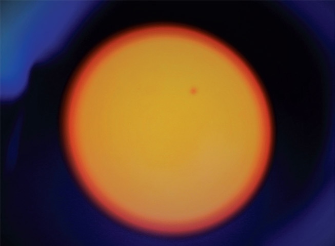
An Image of the sun when Mars came close to Earth in May this year. — Photos by Tanveer Shahzad
A poster at the institute depicts an astronaut in space.
Few residents of the twin cities of Rawalpindi and Islamabad likely know that the country’s largest telescope – capable of observing the solar system, the Milky Way and neighbouring galaxies – is housed in the capital, just 17 kilometres from Zero Point on the Islamabad Expressway.
The telescope observatory is on the roof of the Institute of Space Technology building, in an unassuming area that is an unlikely home to Pakistani scientists and students researching outer space. Although open to students and researchers, anyone with an interest in space can visit the observatory with permission.
Through the telescope, one can see Venus, Jupiter, Mars, Saturn, Pluto, Neptune and Uranus, and the best time to observe the galaxy is at night in an unpolluted environment. Vision is particularly clear after rainfall, when dust has been washed away from the horizon.
In May this year, when Mars neared Earth, Pakistani researchers used the telescope to capture the planet’s movement, which appeared like a dot in front of the sun.
The country’s largest telescope has been installed in an observatory in the capital’s Institute of Space Technology.
“The telescope is the largest functional one in the country, with a 0.4 meter mirror, and observes outer space, the Milky Way and adjoining galaxies,” said Waqas Zubairi, a research assistant at the Institute of Space Technology.
Dr Fazeel Mahmood Khan, who supervises the facility, said it was set up at the institute two years ago. He said the telescope allows individuals to observe distant stars and star clusters, which are at such enormous distances that their light takes thousands of years to reach Earth.
Dr Fazeel Mehmood Khan connects the telescope to a computer, to capture images of a galaxy.
“The telescope is also capable of observing our neighbouring galaxy, Andromeda, at a distance of 2.5 million light years. Although it is the first of its kind in Pakistan, when compared to large facilities in advanced countries, it can only be considered a small baby,” he added.
The telescope rotates through machines, and is connected to a computer.
Dr Khan said several research projects, including observing new extra solar planets, binary stars and gas clouds that give birth to stars and galaxies, are underway in collaboration with international partners.
“Apart from using telescopes, we used the Oak Ridge supercomputer – which is the second fastest supercomputer in the world – to model sophisticated processes involved in the mergers of black holes and galaxies,” he said.
An Image of the sun when Mars came close to Earth in May this year. — Photos by Tanveer Shahzad
“These national and international facilities are key to our graduate programme in astronomy and astrophysics. The programme was launched with the intent to enter, at some point, the elite class of nations that are exploring the mysteries of deep space and the universe.”
- Joined
- Apr 29, 2015
- Messages
- 18,286
- Likes
- 56,238
- Joined
- Jul 12, 2014
- Messages
- 31,923
- Likes
- 148,087
I am assuming this article is a response to the articles about ISRO planning to put a telescope on moon.Pakistan’s largest telescope brings outer space down to Earth
A poster at the institute depicts an astronaut in space.
The country’s largest telescope has been installed in an observatory in the capital’s Institute of Space Technology.
Dr Fazeel Mehmood Khan connects the telescope to a computer, to capture images of a galaxy.
The telescope rotates through machines, and is connected to a computer.
An Image of the sun when Mars came close to Earth in May this year. — Photos by Tanveer Shahzad
Latest Replies
-
 Indian Police Force
- NoobWannaLearn
-
Indian Economy: News and Discussion
- Crazywithmath
-
 Skycraper and Highrises in India
- v952010
Global Defence
-
 Small arms and Light Weapons
- Zoid Raptor
-
 Aircraft Crash Notification
- NutCracker
-
 Drone swarms -India
- LETHALFORCE
-
 Turkish defense industry news updates
- tfxkaanf23
-
 F-35 Joint Strike Fighter
- blackjack
-
 World Military/Paramilitary/Special Forces
- airborneCommando
-
 New Naval Technology
- Blademaster
-
 F-16 Viper
- MiG-29SMT
New threads
-
 World Chess Championship 2024
- SwordOfDarkness
- Replies: 4
-
 Chinese Lunar Exploration Program
- skywatcher
- Replies: 0
-
Boston Dynamics showed flexible new robot Atlas
- Soldier355
- Replies: 1
Articles
-
 India Strikes Back: Operation Snow Leopard - Part 1
- mist_consecutive
- Replies: 9
-
Aftermath Galwan : Who holds the fort ?
- mist_consecutive
- Replies: 33
-
 The Terrible Cost of Presidential Racism(Nixon & Kissinger towards India).
- ezsasa
- Replies: 40
-
Modern BVR Air Combat - Part 2
- mist_consecutive
- Replies: 22
-
Civil & Military Bureaucracy and related discussions
- daya
- Replies: 32