
JAISWAL
Senior Member
- Joined
- Mar 13, 2010
- Messages
- 1,527
- Likes
- 1,027
Tarmak007 -- A bold blog on Indian defence: Indigenous Geographical Information System for military applications ready
++

++

++
.
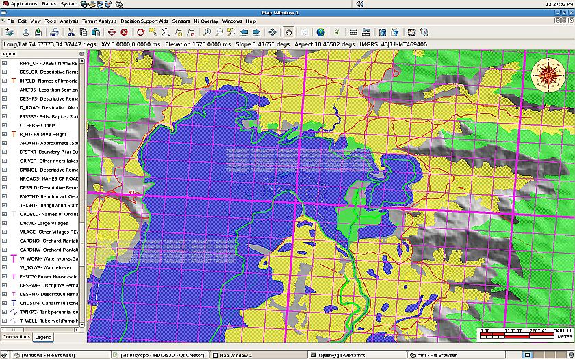
Bangalore: Geographical Information Systems (GIS) play a crucial role in operation planning, execution and monitoring of progress by Armed Forces by showing all entities of interest in the context of a map. The GIS provides spatial information platform such as digital maps, digital elevation maps and satellite images to visualize the operation scenario. This would help enable the disposition of enemy deployments and better planning of own forces' deployment.
Most of the GIS applications used by Indian armed forces are based on commercial off-the- shelf (COTS) software. These COTS GIS come with strict licensing policy and are prone to technology denial. Their interoperability with other GIS systems for exchange of spatial information is limited. To overcome these challenges and pitfalls of COTS GIS, the Centre for Artificial Intelligence and Robotics (CAIR) has undertaken a project to develop home-grown GIS software for military applications, christened as INDIGIS.
"The INDIGIS is a suite of GIS components which are customizable, scalable and data centric. It meets the specific GIS requirements of a collaborative defense environment. The INDIGIS component suite can be customized to build military GIS applications to facilitate planning, execution, monitoring and support of military operations. It offers a common platform for display, analysis and decision support involving spatio-temporal data for Net Centric Operation (NCO) systems," sources said.
Indigenous GIS kernel has been developed as a library of software components to cover the following major function. They are:-
a) processing of geo-spatial data in various formats of interest to Indian military;
b) creation and management of a portable military symbol library;
c) geo-spatial data exchange, analysis and visualization with various Tactical Command Control Communication and Intelligence (TacC3I) systems;
d) analysis and visualization of data from military sensors like GPS, digital compass, Battlefield Surveillance Radar, echo- sounder and unmanned aerial vehicles; f) support for all the usual features of COTS GIS including analysis and visualization of geo-spatial data in 2D and 3D, management of user created spatial data layers (overlays) and simulation modeling and decision support aids for spatial data analysis.
.
INDIGIS FEATURES
* Spatial data interoperability support for majority of commonly-used map and image data formats.
* Scale space visualization for retrieval and rendering of spatial data (raster and vector).
* On the fly projection map data with read-outs.
* Seamless integrated visualization and analysis of topographic -hydrographic data.
* Map updation and trafficabilitity analysis for cross-country movements.
* Integrated tools for military specific requirements like image processing, spatial decision support aids, and modeling tools.
* Portable military symbol library that caters for the requirements of the 3 Services.
* Support for Linux and Windows Operating Systems.
++
++
++
.
Bangalore: Geographical Information Systems (GIS) play a crucial role in operation planning, execution and monitoring of progress by Armed Forces by showing all entities of interest in the context of a map. The GIS provides spatial information platform such as digital maps, digital elevation maps and satellite images to visualize the operation scenario. This would help enable the disposition of enemy deployments and better planning of own forces' deployment.
Most of the GIS applications used by Indian armed forces are based on commercial off-the- shelf (COTS) software. These COTS GIS come with strict licensing policy and are prone to technology denial. Their interoperability with other GIS systems for exchange of spatial information is limited. To overcome these challenges and pitfalls of COTS GIS, the Centre for Artificial Intelligence and Robotics (CAIR) has undertaken a project to develop home-grown GIS software for military applications, christened as INDIGIS.
"The INDIGIS is a suite of GIS components which are customizable, scalable and data centric. It meets the specific GIS requirements of a collaborative defense environment. The INDIGIS component suite can be customized to build military GIS applications to facilitate planning, execution, monitoring and support of military operations. It offers a common platform for display, analysis and decision support involving spatio-temporal data for Net Centric Operation (NCO) systems," sources said.
Indigenous GIS kernel has been developed as a library of software components to cover the following major function. They are:-
a) processing of geo-spatial data in various formats of interest to Indian military;
b) creation and management of a portable military symbol library;
c) geo-spatial data exchange, analysis and visualization with various Tactical Command Control Communication and Intelligence (TacC3I) systems;
d) analysis and visualization of data from military sensors like GPS, digital compass, Battlefield Surveillance Radar, echo- sounder and unmanned aerial vehicles; f) support for all the usual features of COTS GIS including analysis and visualization of geo-spatial data in 2D and 3D, management of user created spatial data layers (overlays) and simulation modeling and decision support aids for spatial data analysis.
.
INDIGIS FEATURES
* Spatial data interoperability support for majority of commonly-used map and image data formats.
* Scale space visualization for retrieval and rendering of spatial data (raster and vector).
* On the fly projection map data with read-outs.
* Seamless integrated visualization and analysis of topographic -hydrographic data.
* Map updation and trafficabilitity analysis for cross-country movements.
* Integrated tools for military specific requirements like image processing, spatial decision support aids, and modeling tools.
* Portable military symbol library that caters for the requirements of the 3 Services.
* Support for Linux and Windows Operating Systems.