Does India Want an 'Undersea Wall' to Detect Chinese Submarines?

Indx TechStyle

Kitty mod
Mod
Joined
Apr 29, 2015
Messages
18,287
Likes
56,238
Country flag
I did not understand. This is my line of thought right from the beginning.
I'm talking of one sided view.
I don't guess you used to troll before as you are doing. Hope you understand and monitor diplomacy of other countries too.
 

HariPrasad-1

Senior Member
Joined
Jan 7, 2016
Messages
9,613
Likes
21,085
Country flag
I'm talking of one sided view.
I don't guess you used to troll before as you are doing. Hope you understand and monitor diplomacy of other countries too.
Other country will play their card and to counter that we need to play ours. If chinese Subs are lurking near our land and sea that we need to take counter measure. Therefore I recommended that sort of wall and monitoring by planes and other surveillance. What trolling did you discover there?

Anyway, did you like my article on china stopping indian entry in NSG?
 

Indx TechStyle

Kitty mod
Mod
Joined
Apr 29, 2015
Messages
18,287
Likes
56,238
Country flag

Listening to the Ocean: India Starts Undersea Project to Monitor Rival Subs
India intends to construct a seabed-based surveillance sensor array. This would monitor all submarine or naval ships patrolling the South China Sea and Indian Ocean Region.

New Delhi (Sputnik) –Indian PM Narendra Modi's government has given its approval to a project under which it will start laying an undersea optical fiber cable to strategically important locations in the Indian Ocean region.
“Union Cabinet has given its approval for the provision of a direct communication link through a dedicated submarine Optical Fibre Cable (OFC) between India's mainland (Chennai) and Port Blair and five other islands viz. Little Andaman, Car Nicobar, Havelock, Kamorta and Great Nicobar,” reads a statement released by Indian government.
Geography and the location of the Andaman and Nicobar Islands in the Bay of Bengal safeguard India's eastern seaboard. The estimated cost of the project is USD 165 mln, including operational expenses for 5 years. The project is likely to be completed by December 2018.
Government sources told to Sputnik that Japan International Cooperation Agency is expected to fund the project. Following its completion, India would construct its own array of seabed-based surveillance sensors stretching from Indonesia’s Sumatra Island to Indira Point in the Andaman and Nicobar Islands. The seabed based surveillance sensors would monitor all submarine or naval ships patrolling the South China Sea and Indian Ocean Region.
Currently satellites are the only medium for providing telecommunications connectivity between the mainland and the Andaman and Nicobar Islands, but the available bandwidth is limited to 1 Gbps.
 

Indx TechStyle

Kitty mod
Mod
Joined
Apr 29, 2015
Messages
18,287
Likes
56,238
Country flag
Undersea Webs

A web of strategic projects is now taking firm shape as India enters into closer multilateral military cooperation relationships with Japan, Australia and the United States, as well as regional powers like Indonesia, Malaysia, Singapore and Vietnam. Matters began taking on urgency in late September 2014, after US President Barack Obama and PM Modi have pledged to intensify cooperation in maritime security. Following this, on March 16, 2015 the defence ministers of the 10-member Association of Southeast Asian Nations (ASEAN) at the end of the two-day 9th ASEAN Defence Ministers’ Meeting in Langkawi, Malaysia, collectively stated that they wanted India to play a far bigger role in both the Indian Ocean Region (IOR) and the South China Sea.

In the near future, therefore, under the auspices of the US–India Defence Framework Agreement, foundational pacts like the Logistics Exchange Memorandum of Agreement (LEMOA), Communication Interoperability and Security Memorandum Agreement (CISMOA), and Basic Exchange and Cooperation Agreement for Geo-Spatial Cooperation (BECA), are likely to be inked by the two countries later this year. Concurrently, Japan can be expected to extend funding from the Japan International Cooperation Agency for the upgradation of naval air bases and construction of new ELINT/SIGINT stations along the Andaman and Nicobar chain of islands, which is made up of 572 islands (of which only 34 are presently inhabited), stretching around 470 miles north to south. But most importantly, preliminary planning has commenced on a Japan-financed project that calls for 1) laying of an undersea optical fibre cable from Chennai to Port Blair; and 2) the construction of an undersea network of seabed-based surveillance sensors stretching from the tip of Sumatra right up to Indira Point. Once completed, this network will be an integral part of the existing US-Japan ‘Fish Hook’ sound surveillance (SOSUS) network that will play a pivotal role in constantly monitoring all submarine patrols mounted by China’s PLA Navy (PLAN) in both the South China Sea and the IOR. This network will in turn be networked with the Indian Navy’s (IN) high-bandwidth National Command Control and Communications Intelligence network (NC3I), which has been set up under the IN’s National Maritime Domain Awareness (NMDA) project at a cost of Rs.1,003 crores. At the heart of the NC3I is the Gurgaon-based, Rs.453 crore Information Management and Analysis Centre (IMAC), whose systems integration software packages were supplied by Raytheon and CISCO.

Oblique references to all these developments were made in the joint statement that was issued last month after the visiting US Secretary of Defense Ashton Carter held delegation-level talks with his Indian counterpart Manohar Parrikar. The joint statement spoke about:

A) new opportunities to deepen cooperation in maritime security and maritime domain awareness;
B) commencement of navy-to-navy discussions on submarine safety and anti-submarine warfare; and
C) enhancing on-going navy-to-navy discussions to cover submarine-related issues.


The US was always interested in Japanese and Indian locations for its SOSUS stations. Initially called Project Caesar, this involved running cables out on continental shelves and connecting them to hydrophones suspended above the sea bottom at optimum signal depths. An ‘experimental station’ was established at the north-western tip of Hokkaido in 1957, with the cable extending into the Soya (La Perouse) Strait. It monitored all Soviet submarine traffic going in and out of Vladivostok and Nakhodka in the Sea of Japan. Undersea surveillance systems and associated shore-based data collection stations code-named Barrier and Bronco were installed in Japan in the 1960s. Acoustic data collected at these sites was transmitted by US defence communications satellites to US Navy (USN) processing and analysis centres in the US. In the 1970s, a network between between Japan and the Korean Peninsula was commissioned. By 1980, three stations at Wakkanai (designated JAP-4), Tsushima (JAP-108) and the Ryukyu Islands (RYU-80) were operational in Japan, along with earlier stations built in the Tsushima Straits and the Okinawa area. The existence of old cables at Horonai Point in north-west Honshu, which during the Cold War led out to SOSUS arrays in the Sea of Japan, has been widely described by scuba divers. By the mid-1980s the SOSUS hydrophone arrays stretched from southern Japan to The Philippines, covering the approaches to China. After the collapse of the USSR and the decline of the submarine threat to the US in the early 1990s, the USN allowed its SOSUS systems in the north-west Pacific to atrophy, although some arrays were retained in working order so as to support civilian scientific research (such as tracking whales and monitoring undersea volcanic activity). According to a USN directive issued in August 1994, all seabed-based fixed-arrays in the Pacific were placed on ‘hot standby’; personnel would ‘not be routinely assigned to monitor fixed-array data’ unless that data was required for operational purposes, but in practice the probability of being able to reconstitute them to full operational status was ‘extremely low’.


However, in the early 2000s, facing an increasing PLAN submarine force and more aggressive PLAN submarine patrols, the USN decided that it needed a new chain of fixed arrays designed primarily to monitor the movement of PLAN submarines between the East China Sea and South China Sea on the one hand, and between the Pacific Ocean and the Indian Ocean on the other. Thus was born the US-Japan ‘Fish Hook Undersea Defense Line’ in early 2005, stretching from Japan southwards to Southeast Asia, with key nodes at Okinawa, Guam and Taiwan. Beginning from near Kagoshima in the southwest part of Kyushu, it runs down the Osumi archipelago to Okinawa, then to Miyako-jima and Yonaguni in the southern part of the Ryukyu Islands, past Taiwan to the Balabac Islands in The Philippines, to Lomkok in the eastern part of the Indonesian archipelago, across the Sunda Strait between Java and Sumatra, and from northern Sumatra to the Andaman and Nicobar Islands. Three major gaps—between Yonaguni and Suao in north-east Taiwan (120km), between Kaohsiung in south-western Taiwan and the Dongsha (Pratas) Islands (450km) where the East China Sea meets the South China Sea, and across the Bashi Channel (220km) between Hengchun at Taiwan’s southernmost tip and Luzon Island in The Philippines—were plugged. In addition, the USN installed a new SOSUS network, stretching from Sasebo down to Okinawa, in 2006, when the US cable-laying ship USNS Zeus operated together with oceanographic survey vessels and nuclear submarines in this area. In July 2013, Beijing claimed that the US and Japan had jointly established ‘very large underwater monitoring systems’ at the northern and southern ends of Taiwan. One of these stretched from Yonaguni to the Senkaku Islands (about 150km), while the other covered the Bashi Channel down to The Philippines. Thus, this US-Japan undersea trip-wire around the PLAN presently extends across the Tsushima Strait between Japan and the Korean Peninsula, and from Japan’s southern main island of Kyushu down past Taiwan to The Philippines. The curve of the hook stretches across the Java Sea from Kalimantan to Java, across the Sunda Strait between Java and Sumatra, and from the northern tip of Sumatra along the eastern side of India’s Andaman and Nicobar island chain. Real-time information-sharing between the US and Japan joins the undersea defence line-up, effectively drawing a tight arc around Southeast Asia, from the Andaman Sea to Japan.

Edited to add picture

Credit: Zebra
 

Indx TechStyle

Kitty mod
Mod
Joined
Apr 29, 2015
Messages
18,287
Likes
56,238
Country flag
US DoD Press Conference on 29-8-2016


Listen to what he says from 17.10 till 22.27 about the maritime awareness domain & the Andaman Sea, when no one even asked him about that sea. This can be reasonably inferred that he certainly had in mind what PSK had originally written about the 'Fish Hook' seabed surveillance network & he took special care to mention the term 'Andaman Sea'

Growing Tentacles

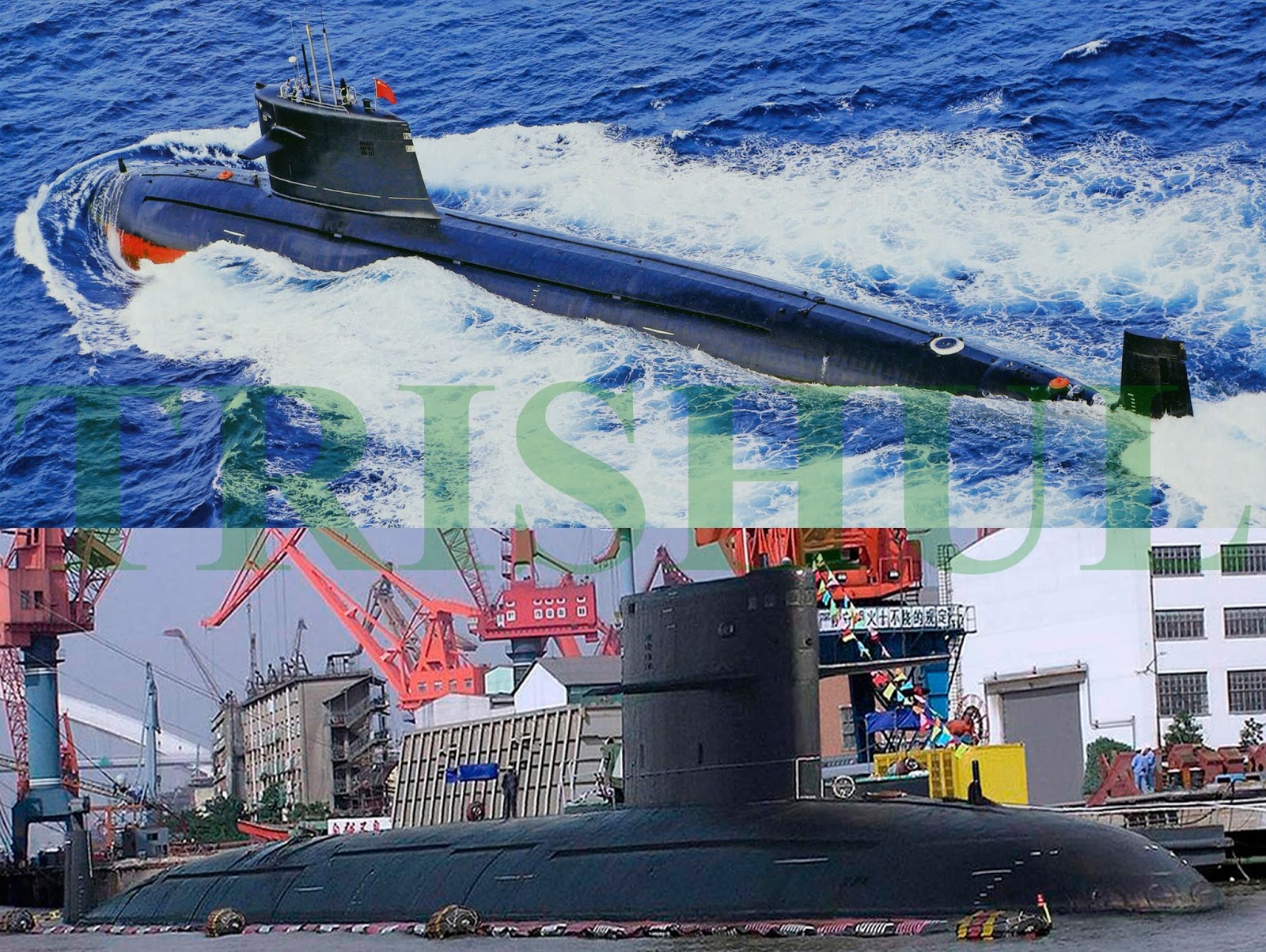
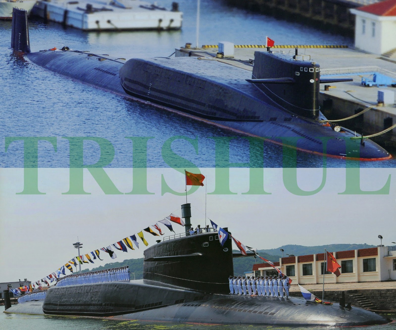
The PLAN presently has an estimated 60 double-hulled submarines, of which 51 are diesel-electric SSKs (two Type 877EKM, ten Type 636, 13 Type 039 Song-class, four S-20/Type 041A Yuan-class, four S-20/Type 041B Yuan-class and 18 Type 035 Ming-class) and eight (four Type 091 Han-class and four Type 093 Shang-class) are nuclear-powered SSNs. In addition, there’s one Type 092 Xia-class and two Type 094 Jin-class SSBNs, with five more of the latter due for delivery in future. Also due for procurement in future are 15 single-hulled SSKs (most likely Russia’s Amur 1650-class) powered by indigenously-developed Stirling Engine air-independent propulsion systems. The number of PLAN submarine sorties has approximately quadrupled over the last seven years, with an average of 12 patrols being conducted each year between 2008 and 2015, following on from six in 2007, two 2006 none in 2005. In the Indian Ocean region (IOR), the PLAN has so far carried out three submarine patrols (all accompanied by Type 925/Type 926 submarine tenders), with the submarines being kept its vessels out at sea for 95 days during each patrol.


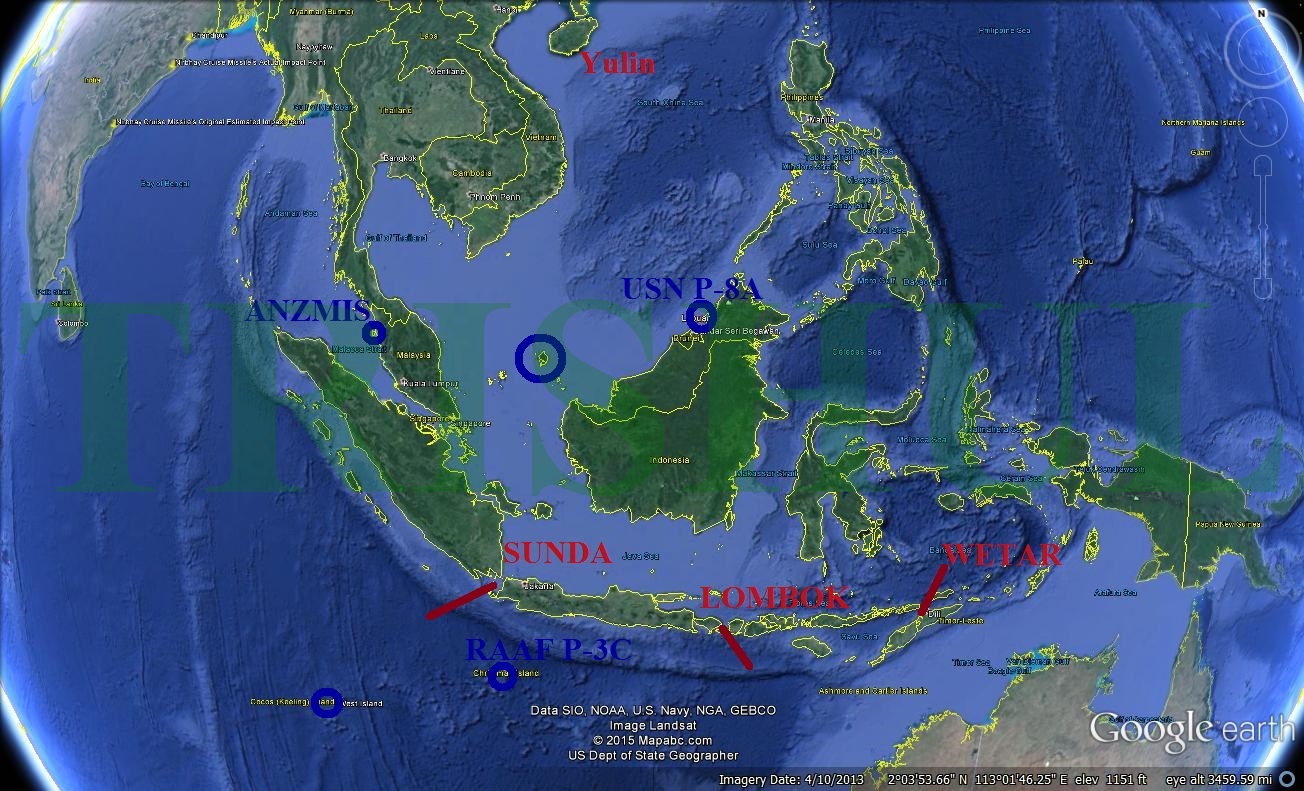
The PLAN’s first SSN patrol within the IOR lasted from December 3, 2013 till February 12, 2014. One Type 093 Shang-class boat left Longpo its bastion at Yulin on December 3. Ten days later, on December 13, the SSN reached the Gulf of Aden via the Ombai Wetar Strait near Indonesia. It remained on patrol in the area for nearly two months. Next to follow was the Type 039 Song-class SSK ‘Great Wall 0329’, which later docked at the China-funded Colombo International Container Terminal in Sri Lanka from September 7 to 14, 2014 along with the Type 925-class tender 
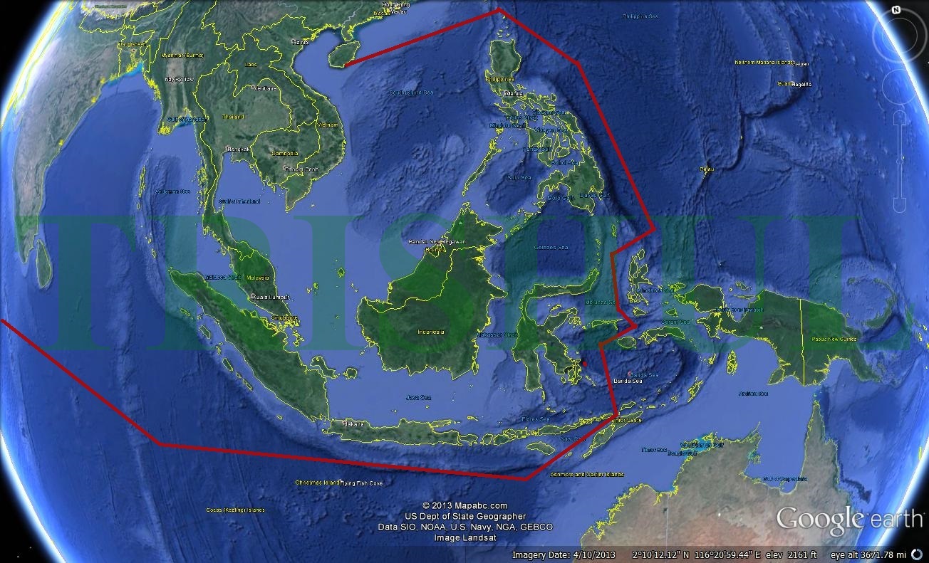
861 Changxingdao. This was followed by a patrol of a Type 091 SSN from December 13, 2014 to February 14, 2015. Next came a S-20/Type 041A Yuan-class SSK that docked at Pakistan’s Karachi port in late May 2015, and was accompanied by a Type 925 Dajiang-class submarine tender. From this, it can be deduced that in the years to come, the PLAN will continue with this practice of launching at the very least two annual long-distance patrols—one each by an SSN and SSK—into the IOR. Entry while remaining submerged into the IOR from either the South China Sea or the Pacific Ocean will be made through either the Lombok Strait or the Ombai Wetar Straits astride Indonesia.


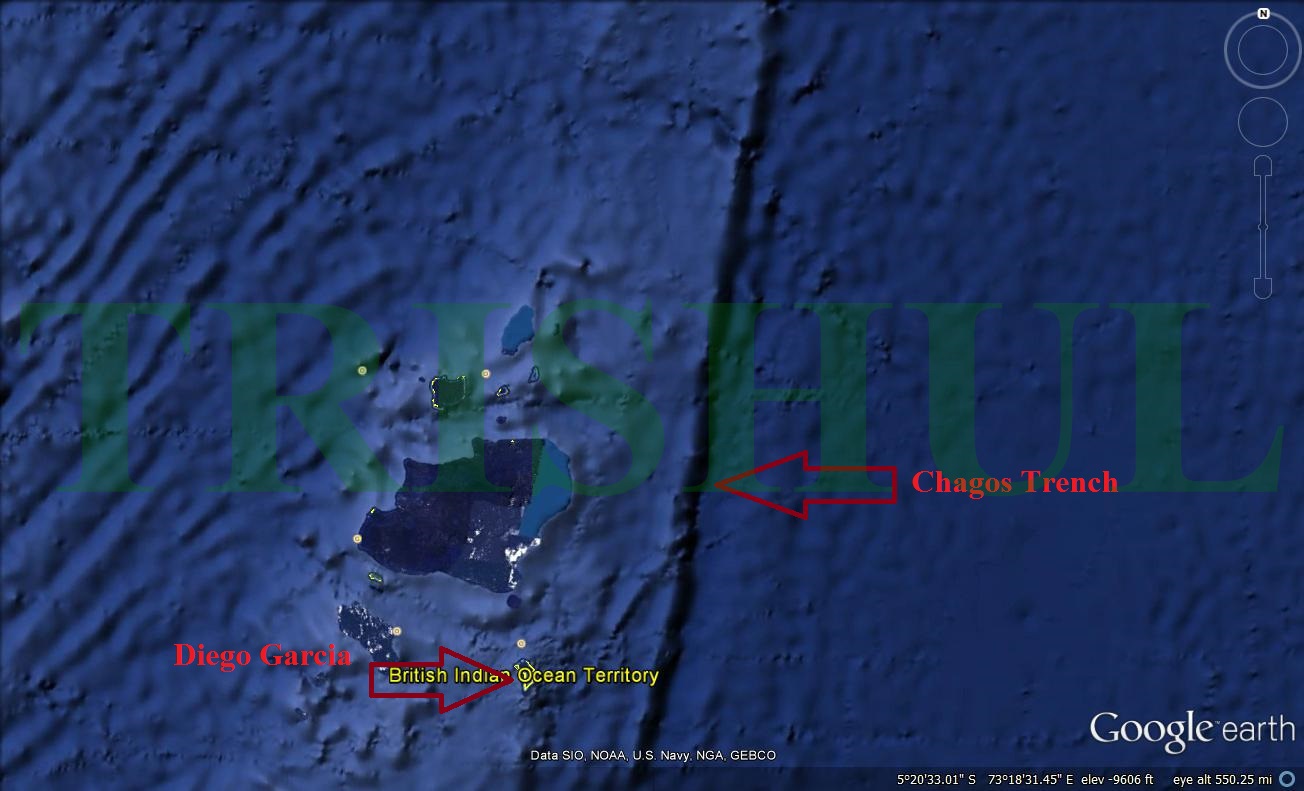
During future hostilities with either the US or India, the most likely destinations of PLAN’s SSNs within the IOR will be the area around Diego Garcia and the Chagos Trench. Diego Garcia is part of the Chagos Archipelago, situated on the southernmost part of the Chagos-Laccadive Ridge. To the east lies the Chagos Trench, a 400 mile-long underwater canyon that ranges in depth from less than 1,000 metres to more than 5,000 metres, and the most likely area where the IN’s SSBNs will be lurking during operational patrols.


All vessels, including warships, enjoy the right of innocent passage through archipelagic waters. Innocent passage requires a vessel to conduct continuous and expeditious transit in a manner that is not prejudicial to the peace, good order or security of the archipelagic state. For a submarine, innocent passage means transiting on the surface, as is the case with the Malacca Strait. But the Lombok Strait astride Indonesia is not considered archipelagic waters, rather it is part of an Archipelagic Sea Lane (ASL) that carves a path from Lombok in southwest Indian Ocean, through the Flores Sea, the Makassar Strait, the Sulawesi and Celebes Seas and on to the Pacific Ocean. It is like this because Indonesia desires sovereignty within the archipelago beyond the normal 12nm territorial water limit, which can be granted in relation to archipelagic states in certain circumstances, provided the ASLs are designated. For a submarine, normal passage means transiting submerged. The other interesting thing about ASLs is that, unlike innocent passage through archipelagic waters, which can be suspended temporarily on a non-discriminatory basis, this is not the case for ASLs. Any PLAN submarine can legally transit Lombok dived. If it chooses to loiter illegally and then gets caught, it can feign normal passage.


Unlike the Sunda Strait—which forms part of a separate ASL, but is realistically too shallow for dived passage by all but the most daring/lucky of submarine operators—the Lombok Strait is relatively deep (varying between 800 and 1,000 metres). At the southern end of the Strait, where the channel is divided by the Island of Nusa Penida, a shallow sill is located. Depths rise to between 200 and 250 metres in the channel to the east of Nusa Penida. The sill is of huge importance to the oceanographic behaviour in the Strait, particularly since the Lombok Sea serves as one of two outlets (the other being the Timor Passage) for a great body of warm water that flows from the Pacific to the Indian Ocean—the so called Indonesian Throughflow. This sill, coupled with the Throughflow and tidal flow, results in relatively large current flows, typically from north to south, but is sometimes reversed. Current flows near the sill can reach 3.5 metres per second during spring tide periods. In the deeper water to the north of the sill it slows to between 0.2 to 0.5 metres. It must be noted, however, that current velocities vary as a function of depth. The upper 100 metres carry 50% of the total water transport through the Lombok Strait. Current velocities are, therefore, maximum at the surface with a sharp decrease from 75 to 300 metres. These currents are a quite significant for submarine operations, particularly diesel-electric SSKs, which must conserve battery life or that cannot take advantage of the deeper areas where the current is minimal. They also create interesting and complicated acoustic conditions for sonar on account of the varying temperature and salinity gradients across the current-related layers.

China’s Undersea Trip-Wire
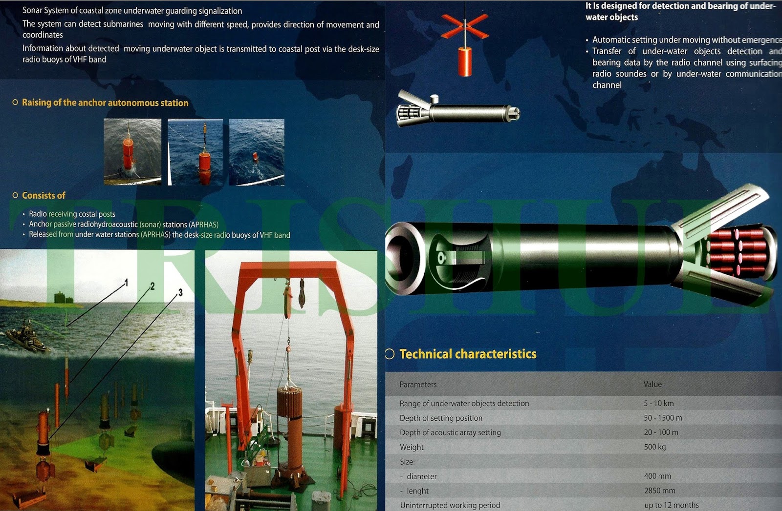
The PLAN’s seabed-based surveillance network, developed jointly by Ukraine and China since 1996, has been under installation along China's territorial waters since 2012, with work expected to be completed later this year. The seabed-based component of this network comprises arrays of hydrophones and magnetic anomaly detectors spaced along undersea cables laid at the axis of deep sound-channels roughly normal to the direction that the arrays are to listen. This capability is next paired with maritime reconnaissance/ASW aircraft assets to establish a multi-tier ASW network. The first naval bases to be covered by this network were the PLAN’s submarine bases in four sites: the Bohai shipyard at Huludao on the Bohai Sea where all nuclear-powered submarines are built; the North Sea Fleet’s Xiaopingdao naval refit base near Dalian where the SSBNs are fitted out for SLBM test-firings from the Bohai Sea across China into Delingha in the Qinghai desert and the desert of Lop Nor in Xinjiang; the North Sea Fleet’s base at Jianggezhuang (Laoshan) approximately 18km east of Qingdao in Shandong Province; and the South Sea Fleet’s bases at Longpo and Yulin at Yalong Bay near Sanya on the southern tip of Hainan Island.

As far back as 2001, a researcher at the PLAN’s Institute 715 had published a survey of ocean surveillance technologies that included a detailed discussion of the US SOSUS programme. Later, one of the most detailed discussions of China’s seabed-based surveillance networks appeared in the journal Shandong Science in 2010. However, Shandong was apparently not the only coastal area pushing forward with R & D on seabed-based sensors. Further down south and located near Shanghai at the mouth of large Hangzhou Bay, an ‘East Sea Ocean Floor Observation Test Station’, also known as the Xiaoqushan Station, was discussed extensively by Chinese researchers in an article appearing in Science Bulletin in 2011. Focussing on the collection of a variety of oceanographic information—tidal and current data, for example—experimentation with sonars is presently ongoing at this station with a wireless data-collection system that was commissioned into service in April 2009. Another analysis by several PLAN researchers in late 2012 discussed this station and military applications for its seabed-based sensors, alongside civilian uses, including environmental protection, navigation, and disaster prevention. The analysis compared different configurations for seabed-based sensor networks, including linear, circular, and tree-type designs, and also evaluating their respective cost, security and reliability implications. It also mentioned the Xiaoqushan Station as the basis for a larger ‘East Sea Ocean Floor Sensor Network’ that will be completed by 2016. The analysis also mentioned undersea mobile sensor stations, as well as fixed seabed sensors.

In early 2013, China Science Daily’s March 26 edition opted to go public with the system by publishing a feature with the banner headline: “Here They Are Quietly Listening to the Ocean: The Whole Story of the Building of Our Country’s First Deep Sea Ocean Floor Sensor Network Base”. According to this article, R & D efforts had commenced in 1996 and an initial prototype of the seabed-based sensor system was tested back in 2005 in the waters surrounding the PLAN’s base at Qingdao in Shandong Province. An additional site was selected for the Longpo naval base, and work formally commenced there in April 2009. Initial set-up was completed in 2010. The undersea-sensor system has since been integrated with a larger surveillance network that also has airborne and space-based components. Two articles appearing in mid-2013 in the technical journal Ship Electronic Engineering, confirmed that this network was now at an active deployment stage. One article discussed the technical challenge of energy supply by proposing a low-power ‘sleep-wake mode’, and mentioned the interesting additional problem that a country’s undersea sensors are subject to being captured by an adversary. Another article discussed the importance of advances in ‘burst communications’ for enhancing the military value of the seabed-based sensor network. A mid-2012 analysis in the naval magazine Modern Ships unequivocally confirmed the existence of PLAN’s network of seabed-based sensors. The cover-story of a second quasi-official naval journal, Naval & Merchant Ships from mid-2013, similarly showed an acute PLAN sensitivity to its perceived vulnerability to Western and Japanese submarines. The central concern shown there was protecting the PLAN’s SSBNs, while the main threat vector mentioned was the USN.

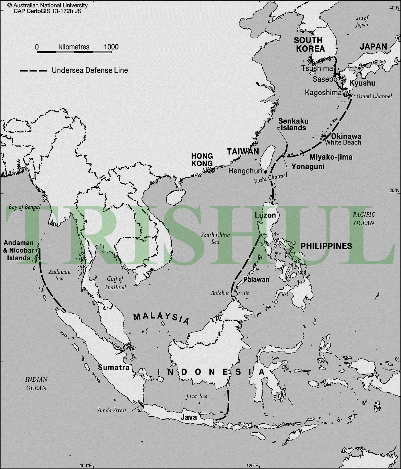
Moreover, it put forward a plausible theory of limited war in the nuclear age: “Limited war theory does not permit the enemy country to become a target. But to win the war one must defeat the enemy’s military forces so that the SSBN can become the ideal target.” The article asserted that the range of PLAN’s SLBMs (the JL-2 SLBM on the Type 094 Jin-class SSBN has a range of 7,400km) must be extended “so that one-way passage to the patrol area is shortened to 5-10 days.” At present, all PLAN-operated submarines are evaluated to be highly vulnerable to detection from “US warships employing active sonar as well as US Navy SSNs lurking near Chinese harbours.” To address this dire situation, the seabed-based surveillance system is deemed critical: “Among the various ASW elements, the seabed-based surveillance system is the foundation and heart, offering advanced warning for the sortie of ASW aircraft and light warship escorts.” The article continued: “The hardest part of ASW is early detection. If China can only find the targets, PLAN’s ASW forces can then apply pressure against the activities of US submarines, limiting their intelligence and attack capabilities.” While this article discusses other critical ASW elements—even highlighting the role of aircraft carriers, for example—a clear focus and conclusion of this analysis is the priority to deploy seabed-based surveillance systems. It envisioned a sequential process: “In order for China to build a relatively tight ASW network, we must first [outside of all major fleet bases] construct fixed seabed sonar arrays for continuous surveillance and control of sea areas close to ports.” The analysis further advocates that after building a network proximate to its naval bases, the PLAN should deploy seabed-based sonar arrays to the west of Okinawa, to the east of Taiwan, and into the Luzon Strait.” Nor should China’s ambitions for undersea surveillance be restricted to the “near seas,” according to this analysis, as it suggested that more distant areas, such as the Bay of Bengal, may be appropriate sites for future Chinese seabed-based sonar arrays “in order to support ASW operations in those sea areas.”
Credit: Zebra
 

busesaway

Regular Member
Joined
Aug 14, 2016
Messages
370
Likes
174
You should post this in the thread concerning Japan-India relations too. It's nice to see military relations moving closer, though I think the money they are giving is quite low.

How much money are Japan providing for the construction? Is it a loan?
 

ezsasa

Designated Cynic
Mod
Joined
Jul 12, 2014
Messages
31,927
Likes
148,110
Country flag
Combine this info with the increase in whales being washed ashore in the past two years, maybe there is something to it.
 

busesaway

Regular Member
Joined
Aug 14, 2016
Messages
370
Likes
174
You should post this in the thread concerning Japan-India relations too. It's nice to see military relations moving closer, though I think the money they are giving is quite low.

How much money are Japan providing for the construction? Is it a loan?
The first article says that Japan International Cooperation Agency will provide $16.5cr to the project, though it doesn't mention if the money is a loan, I presume it's not a loan since the project is cheap enough to fund directly from Union funds.

I wonder when Japan will overturn its constitutional ban against military endeavors. I presume this project is being funded through the JICA because Japan is constitutionally forbidden to do anything outside its remit of 'self-defense'.

But I think it's a positive that Japan and India are moving closer together. I hope India moves forward with military procurement deals with Japan too.

And I while I doubt that the South China Sea will flare up in the same manner the Middle East has, I think it's good for India to expand its soft-military presence overseas, especially in terms of military bases abroad.
 

s002wjh

Senior Member
Joined
Jul 9, 2009
Messages
1,271
Likes
155
Country flag
So India has no issues with US present in India Ocean but China is no no? The way I see it both China and India will challenge US in the future so it's good for US if u two destroyed each other
 

busesaway

Regular Member
Joined
Aug 14, 2016
Messages
370
Likes
174
So India has no issues with US present in India Ocean but China is no no? The way I see it both China and India will challenge US in the future so it's good for US if u two destroyed each other
This is one of my personal pet-hates about Indian foreign policy. It's overtly focused on China while overlooking the problems with Russia and USA.

China has direct conflicts with India, over Pakistan, Tibet, and South China Sea. The United States tends to have 'proxy' conflicts, mainly over Pakistan and Muslims.
 

Indx TechStyle

Kitty mod
Mod
Joined
Apr 29, 2015
Messages
18,287
Likes
56,238
Country flag
India Invites Telecom Majors to Lay Submarine Cables in Indian Ocean
ASIA & PACIFIC
18:27 14.11.2016(updated 20:24 14.11.2016)Get short URL
0 14131

A key Indian military base overlooking the Malacca Straits plans to get connected by secure and fast communication links. India hopes to complete vendor selection and start get the project to lay over 1,300 kms of undersea cables between the base and the southern megapolis of Chennai.


© SPUTNIK/ ALEXEY ZHIDAKOV
India Receives Exclusive Rights for Exploration of Strategic Minerals in Indian Ocean
New Delhi (Sputnik) — India has kick-started plans to provide fast and reliable telecom connection between the island chain of Andaman & Nicobar Islands and the mainland. The state-owned Bharat Sanchar Nigam Limited has invited global bids for improving connectivity to this strategically important location in the Indian Ocean region.
The government has given its approval to a direct communication link through a dedicated submarine Optical Fiber Cable between India’s mainland (Chennai) and six islands of Abdaman & Nicobar Islands at a cost of $ 165 million. Sources told Sputnik that the companies will be selected by January 2017.
Besides being a tourist haven, Andaman & Nicobar Islands are very close to Malacca Straits, a narrow but very busy shipping thoroughfare. India has vastly upgraded its military base with the latest weaponry including Russian Sukhoi-30 MKI combat jets.
 
Joined
Feb 16, 2009
Messages
29,885
Likes
48,598
Country flag
From what people have told me in the past I can tell you something similar to this already
Exists


Sent from my iPhone using Tapatalk
 

Indx TechStyle

Kitty mod
Mod
Joined
Apr 29, 2015
Messages
18,287
Likes
56,238
Country flag
What inconsistent did you find in post in line of my thinking?
You quoted 2-3 months old post.

BTW, I was pointing out immaturity in some of your posts which I think is unusual with you.
From what people have told me in the past I can tell you something similar to this already
Exists


Sent from my iPhone using Tapatalk
Feel free to tell. Who's stopping you?:bounce:
 

Latest Replies

Global Defence

New threads

Articles

Top