CHINESE Medium Altitude Long Endurance DRONES

J20!

Senior Member
Joined
Oct 20, 2011
Messages
2,748
Likes
1,541
Country flag
Not really a MALE drone, but why open up a new thread for just another drone?

http://www.eastpendulum.com/drone-helicoptere-militaire-av500w-evolue

The military helicopter drone AV500W evolves


AIR


BY
HENRI KENHMANN

OCTOBER 6, 2017

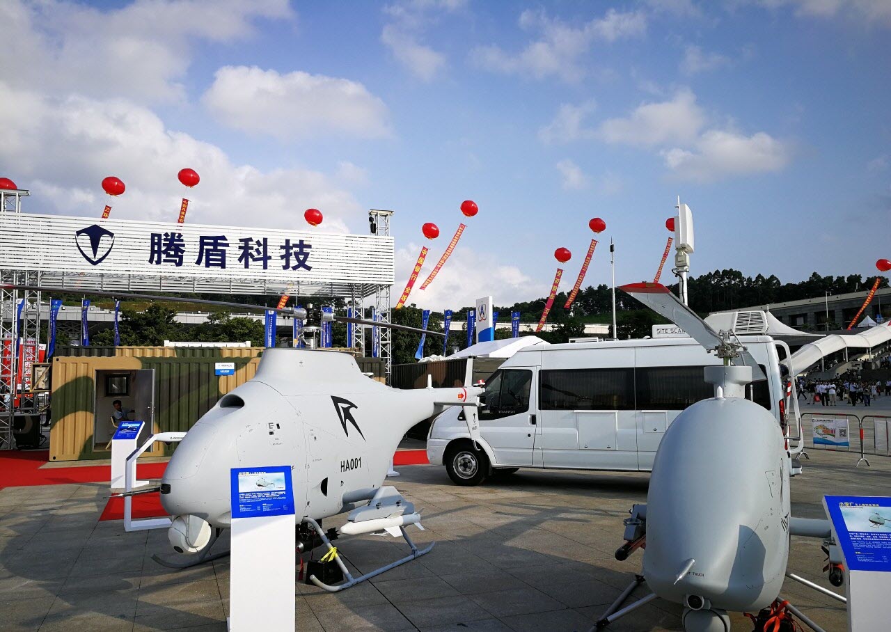
For its second public appearance at the 4th edition of China Helicopter Exhibition in mid-September, the Chinese military VTOL drone AV500W has made a new skin and attracted the eyes of quite a few visitors.

Designed by China Helicopter Research and Development Institute (CHRDI), a research firm specializing in the rotating wing of the AVIC aircraft manufacturer, the AV500W is the armed variant of the AV500 helicopter drone .

The AV500 civil base version is 2,415 meters high, 7,204 meters long and can take off at up to 470 kg with mission payloads not exceeding 160 kg, including 120 kg of equipment, including an optronic ball, a SAR radar and other communication devices.

The aircraft has an 8-hour autonomy in flight and is capable of reaching 4,000 meters of altitude at a maximum speed of 170 km / h.


The digital model of the civilian base drone AV500 (Image: CHRDI)


Its armed version, AV500W, was presented for the first time at the Zhuhai Air Show in November 2016, during which two Saudi delegations, the ADASI company of the UAE Ministry of Defense and the intelligence services of Namibia and of Malawi have all shown great interest in the project .

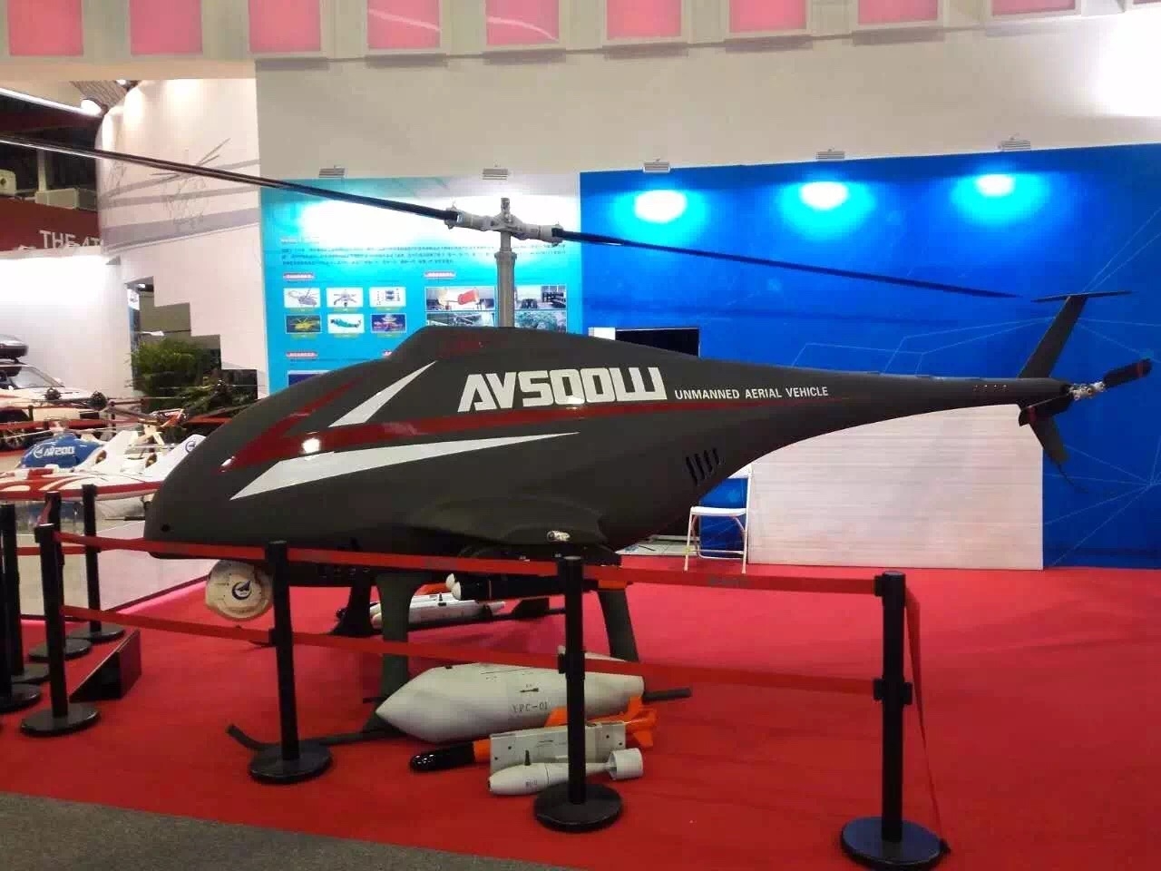
At that time the drone had almost the same physical appearance as its civil twin, with only two fins serving as additional weapons.

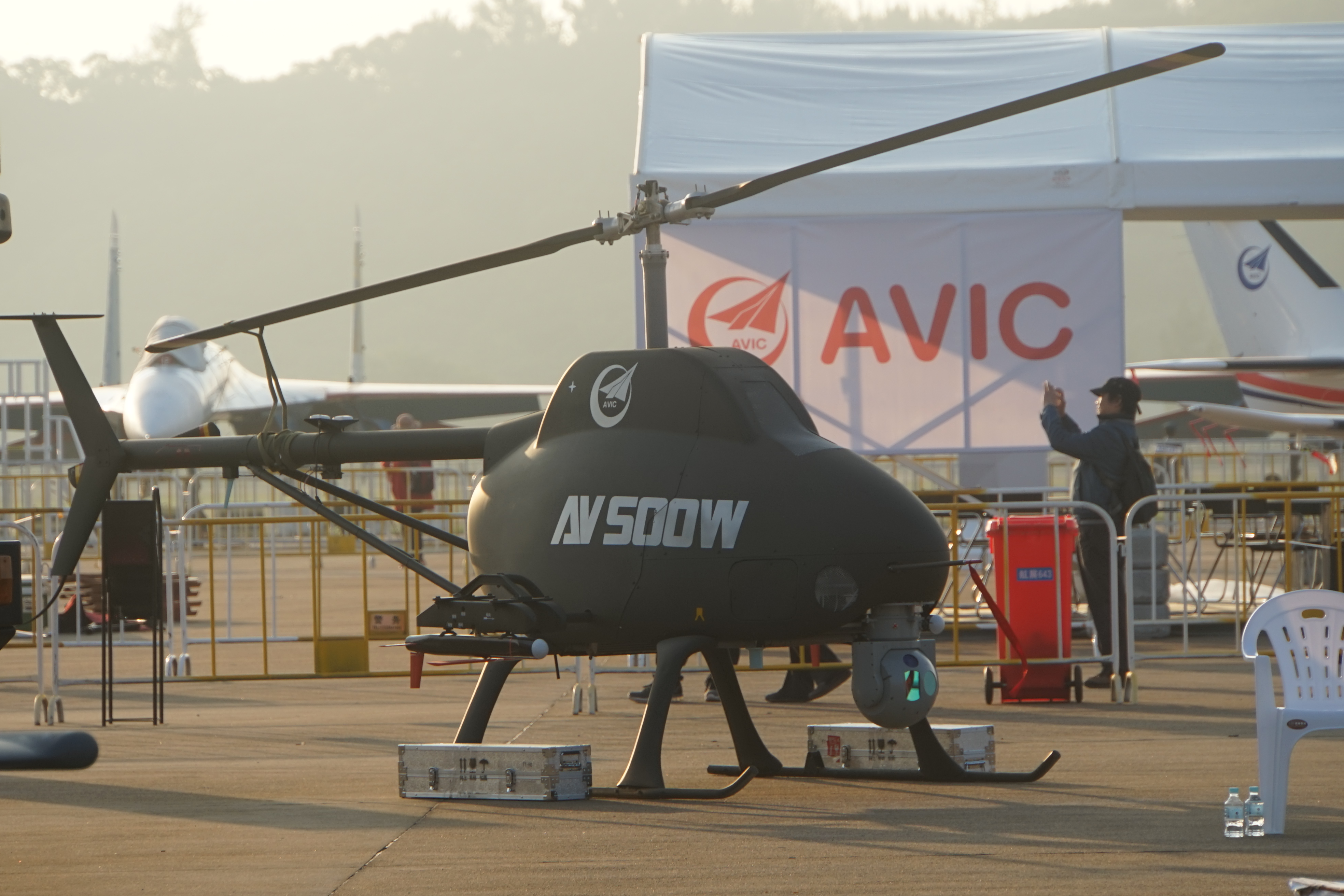
But the "new" AV500W appeared in Tianjin this year is clearly distinguished by a more contoured line and seems to have taken into account passive stealth measures in its new design, at least from the outside.


Former AV500W presented at the Zhuhai Air Show in November 2016


The "new" AV500W appeared mid September in Tianjin


The figures provided by CHRDI during China Helicopter Exposition now mention a MTOW of 450 kg, 20 kg less than the AV500. In-flight autonomy is also reduced to 4 hours only, compared to 6 hours (80 kg of cargo) and 8 hours (55 kg) indicated last year.

The project seems to have made a big step forward since the new video made public shows that the drone has already carried out tests of fire. The AV500W manufacturer presented its armored drone under the new design with a YPC-01 gun pod , two small Air-Sol missiles of 6 and 10 kg each, and two different types of pod of unknown function.

It is unclear whether these developments were required by potential customers, including the Chinese Navy, which is seeking to deploy military helicopter drones for reconnaissance and identification missions.


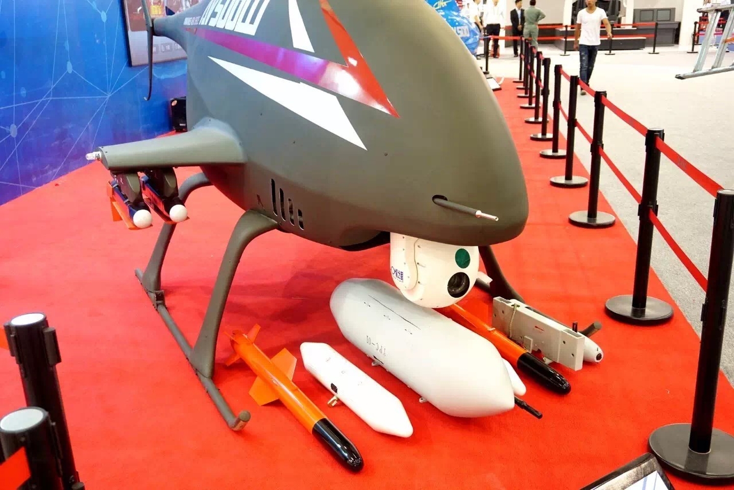
The new armaments of AV500W

Henri K.
 

J20!

Senior Member
Joined
Oct 20, 2011
Messages
2,748
Likes
1,541
Country flag
http://www.eastpendulum.com/drone-1er-vol-reussi-du-tb001-scorpion-a-double-queue

Drone: first successful flight of TB001 "Double tail scorpion"
AIR

BY
HENRI KENHMANN

12 OCTOBER 2017

Tengden (腾 盾 科技), a Chinese company founded in January 2016 and still little known until then, has made itself known recently thanks to the successful inaugural flight of its first drone called TB001 , which becomes one of the largest drones High Altitude-Long Endurance (HALE) of the country.

Already at the last China-ASEAN Exposition Exhibition (CAEXPO) held in Guizhou in mid-September, the young Chinese thumb hit hard by revealing its four different drones at one time - the HALE TB001, the MALE TA001 and two helicopter drones HA001 and HB001 .


The presentation of the Tengden drones at CAEXPO 2017 (Photo: 910 大熊)
The "TB001" is named "Scorpio with double tail", a nickname derived from that of a famous bandit who appeared in the novel " Au bord de l'eau ", which is one of the four classic novels of early Chinese literature. large size Chinese drone with two engines and also two generators on board.

In a twin-wing configuration with high wings, this new Chinese drone is 10 meters long, 3.3 meters high, and has a large span of 20 meters. Its MTOW of 2,800 kg allows it to embark nearly a ton of payloads.

According to the manufacturer's figures, the drone is able to reach an altitude of 8,000 meters and fly at a speed of 260 km / h. Its autonomy is 6 000 km or 35 hours in flight.

The drone is controlled either by a LOS link within a radius of 280 km, or by a satellite link over a distance of more than 3 000 km.

Tengden says that three prototypes of TB001 have been built so far.


Production and inaugural flight of drone TB001 (Photos: 腾 盾 科技)


On Tuesday, September 26, just two weeks after his first public appearance, the double-tail Scorpion successfully completed its inaugural flight that lasted a little thirty minutes.

The location of this first flight test was not reported but it is the Taipingsi military airport in Chengdu, not far from the Tengden site.

Officially, the private company plans to offer its HALE drone for civilian missions such as environmental monitoring, geological surveys, mapping, pipeline inspection, atmospheric research or even sports photography.

But the military ambition is also clearly displayed by Tengden since the TB001 is mainly presented to CAEXPO with a panoply of Air-Sol ammunition, notably the guided bombs of the family FT designed by the Chinese aerospace group CASC.

This is also the case for the three other Tengden drone models, all of which were exposed by weapons.


The drone MALE TA001 (Photo: 910 大熊)


The two Tengden helicopter drones (Photo: 910 大熊)
The question now arises as to how a young company created less than two years ago with a capital of one million yuan, or about 128 thousand euros, already manages to fly a drone of such size and the other three models before the end of the year, when it took several years for some countries to emerge.

Curiosity thus leads us to dig deeper into its management team and its financing.

It turns out that the two founders of Tengden, Dr. GUO Liang (郭亮), 34, and Professor QIN Kai Yu (秦开宇), both teach at the University of Electronic Science and Technology of China ), a university located in Chengdu and ranked first in China in the field of electronics and information technology.


The headquarters of Tengden in Chengdu

It is also reported that QIN has been appointed director of the Institute of Aeronautics and Astronautics of the UESTC since May 2012, while GUO, a graduate of Nanjing University of Aeronautics and Astronautics, is CEO of AOSSCI, a company specializing in the development of drones.

It is assumed, therefore, that the Tengden drone projects actually come from the work carried out by the UESTC on the one hand and the AOSSCI on the other at least at the technical level. This explains why the company has successfully completed the development cycle of four drones in such a short time.

Financially, it is also interesting to note that some local press had called the four Tengden drones, including TB001, as "designed" by the Guangxi Railway Investment Group , a state-owned group focused on railway investment.

It is therefore more than likely that the Tengden Foundation was able to benefit from the funds coming directly from this national group. This is a typical model of what he calls "Production-Education-R & D integration" (产学研 结合) in China.

For example, the same model can be found at Xi'an ASN Technology Group, a supplier of several military drones to the Chinese army, which is in fact a subsidiary of the Northwestern Polytechnic University.

We are therefore waiting to see if this mode of operation will quickly generate first orders for Tengden, if not already, with domestic customers.

To be continued.

Henri K
 

Armand2REP

CHINI EXPERT
Senior Member
Joined
Dec 17, 2009
Messages
13,811
Likes
6,734
Country flag
*sigh

And the "French"/Indian troll arrives. Where's your source for that?

Its called a satellite data-link.:Here's my source:
Hit play, the source is your own video.


J20!

Senior Member
Joined
Oct 20, 2011
Messages
2,748
Likes
1,541
Country flag
Hit play, the source is your own video.

@Armand2REP, pulling numbers out of your ass and posting them doesn't make them fact. That video doesn't mention any specs let alone your 150km figure.

http://www.eastpendulum.com/drone-1er-vol-reussi-du-tb001-scorpion-a-double-queue

According to the manufacturer's figures, the drone is able to reach an altitude of 8,000 meters and fly at a speed of 260 km / h. Its autonomy is 6 000 km or 35 hours in flight.

The drone is controlled either by a LOS link within a radius of 280 km, or by a satellite link over a distance of more than 3 000 km.
You're a "CHINI EXPERT" and all, but I'd rather believe the manufacturer's specifications over your deductions/insinuations. 280 km radius for LOS control or 3000km by data link.


Specs of on the Tengoen TB001 UCAV from the China-ASEAN Expo in Nanning.

Manufacturer specs:
Max take-off weight: 2800kg
Operational ceiling: 8000m
Line-of-sight control radius: 280km
Satellite control radius: 3000km+
Endurance: 35 hours

[/QUOTE
Do you have any other sources for your 150km range figure other than your imagination?
 
Last edited:

Armand2REP

CHINI EXPERT
Senior Member
Joined
Dec 17, 2009
Messages
13,811
Likes
6,734
Country flag
@Armand2REP, pulling numbers out of your ass and posting them doesn't make them fact. That video doesn't mention any specs let alone your 150km figure.

http://www.eastpendulum.com/drone-1er-vol-reussi-du-tb001-scorpion-a-double-queue


You're a "CHINI EXPERT" and all, but I'd rather believe the manufacturer's specifications over your deductions/insinuations. 280 km radius for LOS control or 3000km by data link.


Do you have any other sources for your 150km range figure other than your imagination?
It is simple science applicable to all drones without satellite data links which was demonstrated in your video with the control truck using a parabolic antenna. That means LOS and the range is a function of observable distance to the horizon. Your Chinese manufacturing specs are irrelevant when you must put a payload on it that will drastically reduce its max altitude lowering its LOS. Your drone is grossly underpowered for the weight it must carry further reducing its observable horizon.
 

shiphone

Senior Member
Joined
Nov 9, 2009
Messages
2,163
Likes
2,479
Country flag
双尾蝎固定翼无人机翼展20m,最大起飞重量2800kg,升限8000m,巡航速度最高260km/h,视距任务半径280km,卫通任务半径更是达到3000km以上。
yeah.... the 'idiot expert' is always funny... lol

LOS operation redius : 280 KM
SATCOM operation radius : over 3000 KM


the SATCOM subsystem and SAR payload were also displayed on the EXPO...


the ground control station with SATCOM antenna was exhibited on the outside space of the same EXPO

 
Last edited:

J20!

Senior Member
Joined
Oct 20, 2011
Messages
2,748
Likes
1,541
Country flag
It is simple science applicable to all drones without satellite data links which was demonstrated in your video with the control truck using a parabolic antenna. That means LOS and the range is a function of observable distance to the horizon. Your Chinese manufacturing specs are irrelevant when you must put a payload on it that will drastically reduce its max altitude lowering its LOS. Your drone is grossly underpowered for the weight it must carry further reducing its observable horizon.
Typical internet troll. Blah blah blah... No source, no specs, no clue.

Long story short, you pulled that 150km figure out of your ass. Go troll somewhere else man, haven't you ruined enough threads on this sub-forum with your BS? You've concluded that TB001 is under-powered by looking at a picture of it.

NB. LOS is not limited to 150km fool. The MQ 9's LOS range radius is 150NM ie 280km. http://www.airforce-technology.com/projects/predator-uav/
 
Last edited:

Armand2REP

CHINI EXPERT
Senior Member
Joined
Dec 17, 2009
Messages
13,811
Likes
6,734
Country flag
Typical internet troll. Blah blah blah... No source, no specs, no clue.

Long story short, you pulled that 150km figure out of your ass. Go troll somewhere else man, haven't you ruined enough threads on this sub-forum with your BS? You've concluded that TB001 is under-powered by looking at a picture of it.

NB. LOS is not limited to 150km fool. The MQ 9's LOS range radius is 150NM ie 280km. http://www.airforce-technology.com/projects/predator-uav/
Not at all. I used your own test footage and a horizon calculator.


http://www.ringbell.co.uk/info/hdist.htm

H: 1770m = Distance to the horizon 150.3 Kilometres
 

J20!

Senior Member
Joined
Oct 20, 2011
Messages
2,748
Likes
1,541
Country flag
Not at all. I used your own test footage and a horizon calculator.


http://www.ringbell.co.uk/info/hdist.htm

H: 1770m = Distance to the horizon 150.3 Kilometres
1. That image is not from the TB001's first flight footage.
2. That image is from this article: http://china-defense.blogspot.com/2016/06/alit-ch-4-ucav-remote-kill-via.html from JUNE 2016. More than a year ago!!!
3. That image was taken by a CH4 during a test in which the drone targeted and destroyed a target whilst flying 1000km from the controlling station via a satellite data-link.

Sunday, June 05, 2016
ALIT CH-4 UCAV remote kill via satellite link, testing distance is over 1000km.

Two tests were conducted, one with the current version of the aircraft, the second with upgraded electroptical payload. The new EO ball is now fully upgraded, visual light camera upgraded to 1080p from analog and a 20km target recognition range, FLIR now has continuous zoom and 18km target range, new servo control and target tracking system, added integrated inertial guidance, auto focusing and image enhancing systems. CH4 is quoted to have a take off weight of 1300kg, payload 345kg, ceiling 4000m, and a 35 hours endurance.


4. Just because the drone fired and monitored the target from a 1.72km altitude does not imply that its max altitude is 1.772km. The CH4's max altitude is 4000m/4km.

5. The TB001 and the CH4 are two different MALE drones produced by two different companies. The CH4 has been exported to Saudi Arabia, Iraq and Egypt and has been active for many years. The TB001 is still in prototype phase and has only ever flown once.


6. Stop trolling this thread son. You pulled that 150km range figure out of your ass in an attempt to derail this thread. Get a life my "French" ie Indian friend. It's fun debunking your BS at times, but it gets boring fast.


Last edited:

Armand2REP

CHINI EXPERT
Senior Member
Joined
Dec 17, 2009
Messages
13,811
Likes
6,734
Country flag
@J20! Oh wait, I must have missed it. I did not know you had a hardened military satcom network to run encrypted data links across the globe. Seriously, it only takes the US, French, UK and Italian constellations just to provide coverage for NATO operations. Please let us know what that China constellation is that even lets you run your mystery satcom guided drones. You certainly weren't testing it in that TB001 video with a parabolic antenna and you certainly didn't sell it to the Iraqis.


Look at all those pretty parabolic LOS antennas in the background. :pound:
 

J20!

Senior Member
Joined
Oct 20, 2011
Messages
2,748
Likes
1,541
Country flag
@J20! Oh wait, I must have missed it. I did not know you had a hardened military satcom network to run encrypted data links across the globe. Seriously, it only takes the US, French, UK and Italian constellations just to provide coverage for NATO operations. Please let us know what that China constellation is that even lets you run your mystery satcom guided drones. You certainly weren't testing it in that TB001 video with a parabolic antenna and you certainly didn't sell it to the Iraqis.


Look at all those pretty parabolic LOS antennas in the background. :pound:
I see you're trying to shift focus from the footage from a CH4 you tried to pass off as footage from the TB001's flight. Do you admit that you where wrong about your 150km BS?

As a matter of fact yes, the CH4 systems sold to Iraq are limited to LOS control. What does that have to do with theTB001? The CH4's first demonstration of a strike via satellite data-link was in June 2016, the picture you tried to pass off as footage from TB001. Iraq's CH4's where purchased in early 2015:

https://thediplomat.com/2015/10/revealed-chinese-killer-drones-in-iraq/

The number of satellites China has in orbit number more that the satrlites Italy, the UK and France have put together. Only the US has more active satellites in orbit:

https://www.statista.com/statistics/264472/number-of-satellites-in-orbit-by-operating-country/

Italy, France and the UK do not have any indigenous MALE UCAVs in service either. So I don't know how your Italy/France/UK nonsense prove your 150km BS
 

Armand2REP

CHINI EXPERT
Senior Member
Joined
Dec 17, 2009
Messages
13,811
Likes
6,734
Country flag
I see you're trying to shift focus from the footage from a CH4 you tried to pass off as footage from the TB001's flight. Do you admit that you where wrong about your 150km BS?

As a matter of fact yes, the CH4 systems sold to Iraq are limited to LOS control. What does that have to do with theTB001? The CH4's first demonstration of a strike via satellite data-link was in June 2016, the picture you tried to pass off as footage from TB001. Iraq's CH4's where purchased in early 2015:
You already got called out on the TB001, if you need a reminder of its parabolic LOS antenna see here from your own picture...


The number of satellites China has in orbit number more that the satrlites Italy, the UK and France have put together. Only the US has more active satellites in orbit:

https://www.statista.com/statistics/264472/number-of-satellites-in-orbit-by-operating-country/
What kind of logic do you have that equates number of satellites to a specific type of satellite, ie hardened military SATCOMs? Wait do you actually pay $49 a month just see how many satellites you have? :rofl:

Italy, France and the UK do not have any indigenous MALE UCAVs in service either. So I don't know how your Italy/France/UK nonsense prove your 150km BS
We have Predator drones thanks because they are the best but actually have the encrypted SATCOMs to run them. You on the other hand have hardwired infrastructure not capable of supporting operations outside your territorial borders.
 

J20!

Senior Member
Joined
Oct 20, 2011
Messages
2,748
Likes
1,541
Country flag
You already got called out on the TB001, if you need a reminder of its parabolic LOS antenna see here from your own picture...


What kind of logic do you have that equates number of satellites to a specific type of satellite, ie hardened military SATCOMs? Wait do you actually pay $49 a month just see how many satellites you have? :rofl:


We have Predator drones thanks because they are the best but actually have the encrypted SATCOMs to run them. You on the other hand have hardwired infrastructure not capable of supporting operations outside your territorial borders.
1. Called out by what? Your make believe 150km figure? Yeah, of course it has an LOC antenae considering that it can operate via LOS or satellite data link.

Specs of on the Tengoen TB001 UCAV from the China-ASEAN Expo in Nanning.

Manufacturer specs:
Max take-off weight: 2800kg
Operational ceiling: 8000m
Line-of-sight control radius: 280km
Satellite control radius: 3000km+
Endurance: 35 hours
2. Here,'s the TB001's satalite data link antannae.. Why are you ignoring it and acknowledging only the LOS antennae?


All advanced MALE UCAV's have both LOS and satellite data link control functions slowing them to operate thousands of km's away from their control stations. The MQ9 predators LOS range is 280km's too by the way.

3. Stop pretending to be French my Indian friend. The French and UK armed forces use the predator because they have no indigenous platform capable of performing the same function currently. Try not to sugar coat it. Same goes for your native India.

4. The CH4has already demonstrated a strike via satellite data link a year agao. I've provided a link for that. You unwittingly provided the footage of that strike in your attempt to falsely justify your bullsh*t 150km figure.

http://china-defense.blogspot.com/2016/06/alit-ch-4-ucav-remote-kill-via.html

https://www.popsci.com/chinese-drones-make-key-breakthrough-firing-on-command-by-satellite

LAUNCH FROM THE OTHER SIDE OF THE WORLD

This CH-4 Unmanned Combat Aerial Vehicle (UCAV), with an improved electro-optical sensor turret, fires an anti-tank missile during a test. With its pilots sitting in a control station 1,000km away, the Chinese usage of a satellite link for combat operations is a major boost to Chinese global military capabilities.
Must I repost the pics? You can't simply ignore the facts that are inconvenient for your self-gratifying theories. Pretending China doesn't have the orbital assets in place doesn't make it so. I repeat operator of the second largest satellite constellation.
 
Last edited:

Armand2REP

CHINI EXPERT
Senior Member
Joined
Dec 17, 2009
Messages
13,811
Likes
6,734
Country flag
@J20 Must I repost the actual test video of the TB001?


There is your parabolic LOS antenna again, not SATCOMs of which you have no constellation to test it.
I am more than happy to cut through your propaganda again. :bounce:
 

J20!

Senior Member
Joined
Oct 20, 2011
Messages
2,748
Likes
1,541
Country flag
It's not a MALE uav but looks like the EA-03 HALE UAV is in PLAAF service with 0 announcements made:

http://www.eastpendulum.com/drones-longue-portee-ea-03-deployes-a-la-frontiere-sino-indienne

EA-03 long-range drones deployed at the Sino-Indian border


BY
HENRI KENHMANN
OCTOBER 7, 2017

If it is difficult to speak objectively about the recent conflict between India, Bhutan and China in the Doklam region, which resulted in the (temporary) withdrawal of all parties as of August 28th , it can at least be confirmed that the Chinese armed forces had progressively strengthened on the Sino-Indian border for the duration of the confrontation, deploying several fighter planes, fighter bombers as well as long-range reconnaissance drones EA-03, better known as the " Soaring Dragon " that the prototype carries, in one of the five Chinese airports in Tibet.

The information was first revealed by our colleague huitong, author of Chinese Military Aviation . According to the satellite images of Shigatse Heping Airport from August 24 this year - four days before the end of the confrontation - at least three EA-03 drones, eight J-10 fighters, two JH-7A fighter bombers and two Su-30MKK heavy bomber bombers were identified on site, less than 250 km as the crow flies from the exact location of the conflict.

Other, more recent images, as of September 6, indicate that the same EA-03s were still moving in the area after the showdown.


Shigatse-Heping Airport, August 6, 2017 (Image: TerraServer)


The image as of August 24, 2017, three EA-03 are located near the track (Image: TerraServer)


On September 6th, the three EA-03s are still in motion (Image: TerraServer)
These images not only confirm that the new EA-03, High Altitude and Long Endurance (HALE) drone, has indeed entered active and operational service, but there was above all a clear intention of the Chinese army to to carry out a precision military operation on its border with India, which requires means of surveillance and recognition at the same time close and almost permanent presence.

Developed by the 611 Chengdu Institute of the AVIC group, the same design office that designed the J-10 , J-20 and FC-1 fighters , the EA-03 is a drone with more than 7,000 kg take-off and capable of flying at 750 km / h on a cruise ceiling at 18,000 meters altitude.

Characterized by its configuration a bit special rhomboid wing, the machine has a consistent autonomy of 7,000 km, or 36 hours in flight, according to its designer.

This relatively large range gives the EA-03 a range of about 3,000 km, enough to cover all of India, or even beyond. If deployed locally on a front line and relayed to several, it allows the Chinese army to keep an eye and ears permanently on 600 km deep from the point of conflict in Doklam.

And it is probably for these reasons that three EA-03s were simultaneously at Shigatsé Heping, where the word Heping ironically means "Peace" in Chinese.

It is currently unclear whether these three HALE drones from the Chinese army are part of those that came out of the Anshun factory in 2016 or were produced before. Be that as it may, it is not excluded that this is the first operational deployment of the EA-03.


At GAIC's Anshun plant where EA-03s are produced, at least 4 of these drones rolled off the assembly line in August 2016 (Image: DigitalGlobe)


An EA-03 assembly in Anshun (Photo: GAIC)
As for the other fighter planes in Shigatsé Heping, the information indicates that the units of the Chinese Air Force actually come in turn and are not permanently stationary in place.

For example, the J-10 seen on the satellite images in early August would come from a unit of the Southern Theater Command, which replace the other J-10s of the Western Command who invested the same between April and July.

Moreover, the fact that Chinese fighter bombers JH-7A and Su-30MKK are also present also shows that the Chinese army did not only intend to protect its airspace, with J-10 type interceptor fighters. but would also have been prepared to hit Indian targets on the ground if the showdown would continue.

If we believe in the Indian media NDTV, China would have resumed the construction of roads in Doklam . Materials not used in the previous attempt would have been moved to another site, under the protection of 500 Chinese soldiers.


The five Chinese civil-military airports in Tibet


Shigatse-Heping Airport, Bhutan and Arunachal Pradesh
Still on the border with Bhutan but east, in Arunachal Pradesh, a Mi-17 Indian Army crashed on October 6 by killing the 7 people on board. The helicopter was on a refueling mission at an avant-garde station in a disputed zone with China.

To be continued.

Henri K
 

Screambowl

Ghanta Senior Member?
Senior Member
Joined
Jan 1, 2015
Messages
7,950
Likes
7,908
Country flag
Impressive
drones + their rocket arty will give sufficient cover to Chinese PLA and Indian soldiers will be caught with their pants down once again.

Looks like administration in India is busy fighting elections and they don't care about threats.
 

IndiaRising

Senior Member
Joined
Oct 10, 2014
Messages
2,788
Likes
9,592
Country flag
Impressive
drones + their rocket arty will give sufficient cover to Chinese PLA and Indian soldiers will be caught with their pants down once again.

Looks like administration in India is busy fighting elections and they don't care about threats.
yeah, thats why they ran with their tail tucked behind their arse the first time around. all of this drone bs is worth nothing when their own government realized that the trade deficit they enjoy against india will wither away if they continue to warmonger
 

Screambowl

Ghanta Senior Member?
Senior Member
Joined
Jan 1, 2015
Messages
7,950
Likes
7,908
Country flag
yeah, thats why they ran with their tail tucked behind their arse the first time around. all of this drone bs is worth nothing when their own government realized that the trade deficit they enjoy against india will wither away if they continue to warmonger
They realized it but the way they are beefing up their military at sino Ind border looks like they are preparing for future.

They might soon deploy their CH3-Ch4 or already have .. I suppose. What India has to counter it? That butterfly lakshya and or Rustam mochi wala number 2? None of them are yet properly developed.
 

Aghore_King

Regular Member
Joined
May 8, 2017
Messages
460
Likes
1,121
Country flag
How about destroying drones in flight with cheaper turbo prop jets ...is it plausible...??
 

Latest Replies

Global Defence

New threads

Articles

Top