Frontier Infrastructure: What's up on the PRC or Chinese side?

bennedose

Senior Member
Joined
Jun 21, 2013
Messages
1,365
Likes
2,169
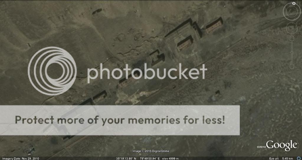
The road pattern at the LAC near DBO/Depsang plain is as follows. There are two roads that run for a few km parallel to the LAC. One is a big lollipop loop in the south and the northern one is a T.


The "T" roads that the Chinese have here and elsewhere at the LAC have a characteristic loop at the end to allow patroling vehicles to do a U-turn and retuen to patrol up the other way. Here is an enlargement of the southern end of the T road in the above image. The road is about 5-6 meters wide


To my mind this pattern of roads at the LAC indicate the following things
1. The fact that it runs parallel to the LAC appears like a de facto acceptance of the LAC as it is.
2. The Chinese keep a close watch on the LAC by patrolling in vehicles. I wonder if the drivers have oxygen bottles while they patrol. I have read that O2 bottles are provided for some patrols. That is good for soldier's comfort, but it only delays acclimatization
3. If the parallel roads are a de facto acceptance of the LAC, then the 18 km provocation westwards on the Depsang plain mean that the Chinese are constantly on the lookout to extend their territory and will simply move across if they feel an area is unattended - somewhat like a Kargil intrusion. IOW they cannot be trusted.
 

Ray

The Chairman
Professional
Joined
Apr 17, 2009
Messages
43,132
Likes
23,835
2. The Chinese keep a close watch on the LAC by patrolling in vehicles. I wonder if the drivers have oxygen bottles while they patrol. I have read that O2 bottles are provided for some patrols. That is good for soldier's comfort, but it only delays acclimatization
The maps at Post # 21 are most interesting.

Could you also append such maps for all the areas of the LAC. I know I am asking for too much, but then it will be a great reference.

@Singh, @Yusuf,

Once this thread runs its life, it would be wise to Archive it. The maps and the discourse is more exhaustive than what is available in the open fora.


On coming into High Altitude, one has to undergo a minimum Three Stage Acclimatisation before one can operate.

Thereafter, one is 'normal' and can undertake all type of work to include heavy duty work, though one would still require more frequent breaks than one would require in the plains.

The locals are of course a different kettle of fish and display greater efficiency than the plainsmen.

O2 bottles are not required in vehicles as such, but carrying them is a good precaution.

Notwithstanding, there is no guarantee that High Altitude ailments, to include pulmonary oedema, will not strike you.
 
Last edited by a moderator:

bennedose

Senior Member
Joined
Jun 21, 2013
Messages
1,365
Likes
2,169
Tonnage Through Tibet

SECRET

A methodology for assessing highway logistics applied in the Chinese Communist attack on India.
Ray saab - than you for this valuable post. This is exactly the sort of information I was searching for but could never find.

Each branch road from the G 219 to the LAC in Aksai Chin varies from 120 to over 200 km in length and none of them are "pucca" all the way. All cross river beds at some place or other, All are above 5 km high in altitude. Below is an image of a truck on the track from the DBO area to G 219. The truck appears to be going to the G 219 and is 15-20 km away from the G 219. The track is about as wide as the truck - i.e. 4 meters and is hardly a highway. It appears to be a kutcha track. A trail of what might be dust is seen behind the truck.


Note that this truck is on the shortest road from the G 219 to the LAC. The lines I have drawn along the highway indicate the length of this road - so the distance from the G 219 to LAC to be 170 km on this track/road. There is another road/track to the south leading from the G 219 to the DBP/Depsang area. That is over 220 km long.
 

Ray

The Chairman
Professional
Joined
Apr 17, 2009
Messages
43,132
Likes
23,835
@bennedose.

The Methodology that I have appended, is a rough and ready reckoner and is not universally applicable.

The track that you show on that map will surely make movement slower than what maybe predicted.

What is important to note is that more the passes of vehicles over these types of tracks, the worse the surface becomes, and in the end, if not maintained, they can even vanish!
 
Last edited by a moderator:

bennedose

Senior Member
Joined
Jun 21, 2013
Messages
1,365
Likes
2,169
The maps at Post # 21 are most interesting.

Could you also append such maps for all the areas of the LAC. I know I am asking for too much, but then it will be a great reference.
No Sir you are not asking for too much. My intention is to try and provide everyone with exactly this information. And hopefully after I am done with Aksai Chin I can do the same for the Tibet side of the Arunachal Pradesh border. Of course another name for Tibet is "North Arunachal" LOL!

I hope you have Google Earth installed on your computer. If not you wil have to install it - it is free.

To see all the roads and marks I have made please download the following file
https://docs.google.com/file/d/0B3JNY4IY8u2bZW1jckYxRWVWTWM/edit?usp=sharing

Click on the downloaded file and it will open in Google Earth to display all the marks I have made. it looks like a confusing mess but you can see details if you zoom in
 

W.G.Ewald

Defence Professionals/ DFI member of 2
Professional
Joined
Sep 28, 2011
Messages
14,139
Likes
8,594

bennedose

Senior Member
Joined
Jun 21, 2013
Messages
1,365
Likes
2,169
The locals are of course a different kettle of fish and display greater efficiency than the plainsmen.
Ray, Tibetans have a genetic mutation dating from 10,000 years ago that allows them to survive at altitude better than plainsmen.
 

Ray

The Chairman
Professional
Joined
Apr 17, 2009
Messages
43,132
Likes
23,835
No Sir you are not asking for too much. My intention is to try and provide everyone with exactly this information. And hopefully after I am done with Aksai Chin I can do the same for the Tibet side of the Arunachal Pradesh border. Of course another name for Tibet is "North Arunachal" LOL!


Very appropriate.

Salman should learn of this and he will be wiser!
 

Kunal Biswas

Member of the Year 2011
Ambassador
Joined
May 26, 2010
Messages
31,122
Likes
41,042
It would be wise if there are no political interference in military plannings, which is highly unlikely when talking about present Gov..

===========================


Srinagar-Leh national highway widened for T-72 tanks

===========================

About Light tanks, Its not in option for us..

But other sides is well prepared..

------------

Though this is an off-topic, And want to keep this minimum..

Yes, Sir. One thing I am clueless about, how do we plan to move our armour in the relevant theater (ex. some flat lands north of Chicken-neck enclave or Tibetan plateau). While we do not have the option of railroads & capable roads, even our airlift capability would not be enough is being able to ferry enough mass of armour in a defined time-window.

Even the best we have (C-17) can only airlift 1 of our tanks at a time (or maybe, 2, if engine, APU, ammunition, fuel is ferried separately).

APC's & IFV's alone might not be enough for counter-offensives & we do not have any plans for light-tanks.

Even light-artillery acquisition has failed to take-off (maybe, FMS route could fix that at some point of time).
 

Kunal Biswas

Member of the Year 2011
Ambassador
Joined
May 26, 2010
Messages
31,122
Likes
41,042
Towards Sikkim area, It is proposed long time back, I am assuming works is already on the way that too is some time back..


@bennedoseOne should also take in the tonnage that can be brought up through the Tibet Railway.

I believe they are extending the railways beyond Lhasa.
 

bennedose

Senior Member
Joined
Jun 21, 2013
Messages
1,365
Likes
2,169
Looking at the terrain in the Aksai Chin area I doubt if tanks would be appropriate for various reasons. Aksai Chin is a plateau and it ends on the Indian side in mountainous terrain with alternating high mountains and deep valleys. Because Aksai chin is flat in some (but not all) areas it is conducive to road transport although the Chinese do not appear to have built pukka highways. So while I am sure tanks would be useful on the plateau itself, the logistics of keeping anything other than a small number there would be impractical. No road through Aksai Chin fails to pass through mountains or over rivers

On the other hand I have always felt that the terrain is great for fast lightly armoured vehicles and a special breed of armed helicopter that can operate effectively that those altitudes. I suspect our Dhruv would do well here. Less sure about Apaches.

Could the Chinese bring tanks to the area? I am sure they can bring them, but their logistics lines are also over 150 km in length through rough terrain situated at 5000 plus meters. Interdiction of supply roads would leave the tanks vulnerable to air attack in the open spaces of Aksai Chin. besides - once the tanks get further west towards India you get mountains that tanks cannot negotiate.
 

bennedose

Senior Member
Joined
Jun 21, 2013
Messages
1,365
Likes
2,169
This is the Karakax River at its upper reaches, very close to the Hot Spring Area where an Indian patrol was ambushed in the late 50s. The Kizil Jilga which originates at the end of Raki Nala flows east into the Karakax River at a place little south of this bridge. To the further east, lies a lake, and to the north flows this river, which then turns east, joins Yurungkax river to become the Hotan river, and against north into Hotan area or Tarim Basin. Interestingly, much of Highway G219 is along Yurungkax river.
I am unsure of the exact location of Raki Nala, but I know approximately where it is and it is east of this area. There is a river that flows east across the LAC from the Depsang plain area that joins the Karakax rtiver a little south of the 75 meter bridge. Most of the Chinese installations and buildings are along this river all the way to the LAC, and that includes 2 smaller (20-25 meter) bridges, several crossings across river beds and a barnch road that leads a tunnel - all of which I have marked on the map/kmz.
 

pmaitra

Senior Member
Joined
Mar 10, 2009
Messages
33,262
Likes
19,594
I am unsure of the exact location of Raki Nala, but I know approximately where it is and it is east of this area.
Raki Nala
Holistic map (very important)

There is a river that flows east across the LAC from the Depsang plain area that joins the Karakax rtiver a little south of the 75 meter bridge.
That is the Kizil Jilga.

Most of the Chinese installations and buildings are along this river all the way to the LAC, and that includes 2 smaller (20-25 meter) bridges, several crossings across river beds and a barnch road that leads a tunnel - all of which I have marked on the map/kmz.
Understandably. It is a river valley, and gives direct access to DBO and Depsang Plain area.
 

bennedose

Senior Member
Joined
Jun 21, 2013
Messages
1,365
Likes
2,169
Does this mean that Raki Nala is part of the. watershed of the Tarim basin?

OK got it - just saw that very informative holistc map.
 
Last edited:

Latest Replies

Global Defence

New threads

Articles

Top