Agricultural Patterns around the world

mayankkrishna

Regular Member
Joined
Dec 25, 2010
Messages
264
Likes
359
Country flag

Agricultural fields south-west of Perdizes, Brazil, photographed from the international space station. A mix of regularly gridded polygonal fields and circular centre-pivot fields mark the human land use of the region. Small tributary streams (and their adjacent floodplains) of the Araguari river extend throughout the agricultural landscape. The visual diversity of field forms is matched by the variety of crops produced here: sunflowers, wheat, potatoes, coffee, rice, soybeans and corn


Vestiges of Medieval Brittany among signs of modern civilisation in this simulated natural colour satellite image of Chateaubriant, France. The small city is silver, coloured by light bouncing off the reflective surfaces. The surrounding country is an irregular patchwork of small fields, reflecting land use in the Middle Ages. Plant-covered land is still green and water is dark blue. By late November, crops had been harvested and many of the fields were bare. The exposed soil ranges from pale tan to brown in the image. Other fields (possibly pastures) remained green, even late in the year. Patches of forest on the right and lower edges of the image are brown and dark green


In Minnesota the very regular grid pattern reflects early 19th-century surveying; the size of the fields was determined by the need to have a big enough area to make the use of machinery efficient


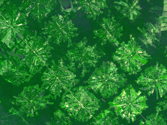
Near Santa Cruz, Bolivia, the radial-pattern fields are part of a planned settlement scheme in a rainforest area. At the centre of each unit is a small community, which is surrounded by fields. A small buffer of forest separates the settlements from one another


Outside Bangkok, Thailand, rice fields fed by an extensive network of canals that is hundreds of years old appear as skinny rectangular fields. Some fields seem to be flooded (deep purple), which is part of the growing cycle of rice plants


From mainland Ukraine, the Crimean peninsula extends southward, bordered on the west by the Black Sea and on the east by the Sea of Azov. Stretching across the peninsula is a network of shallow, marshy inlets sprawling over roughly 1,000 square miles (2,600 square kilometres). This network of lagoons is known as Sivash (also Syvash or Sivasÿ). Surrounding the marshy areas are agricultural fields, most of them rectangular, but some are shaped by centre-pivot irrigation systems. Urbanised areas appear along the shores of the Black Sea, and highways curve and zigzag across the peninsula


South of Khartoum, Sudan, where the White and Blue Nile rivers join, a dizzying arrangement of irrigated fields stretches out across the state of El Gezira. Given the semi-arid climate of the surrounding area, this geometrical spectacle of fertile green fields depends on thousands of miles of canals and ditches that connect the region to the Blue Nile in the west. The man-made rivers and streams are part of an irrigation project called the Gezira scheme, which the British started in the colonial era to grow cotton for export back to Europe


Resembling a work of modern art, variegated green crop circles cover what was once shortgrass prairie in south-western Kansas. The most common crops in this region are corn, wheat, and sorghum. Each of these crops is at a different point of development, accounting for the varying shades of green and yellow
 

mayankkrishna

Regular Member
Joined
Dec 25, 2010
Messages
264
Likes
359
Country flag

The south-western coastline of the Netherlands is a series of islands crisscrossed with river outlets and estuaries. The patchwork of green, cream, and lavender colours on the islands shows the prevalence of agriculture in the province and fields in various stages of growth or harvest


The Orange River serves as part of the border between Namibia and South Africa. Along the banks of this river, roughly 100km (60 miles) inland from where the river empties into the Atlantic Ocean, irrigation projects take advantage of water from the river and soils from the floodplains to grow produce, turning parts of a normally earth-toned landscape emerald green


Green circles in the desert frequently indicate tracts of agriculture supported by centre-pivot irrigation. The Al Khufrah oasis in south-eastern Libya is one of Libya's largest agricultural projects. Because only about 2% of Libya's land receives enough rainfall to be cultivated, this project uses fossil water from a large underground aquifer. Darker colours indicate fields where such crops as wheat and alfalfa are grown. Lighter colours can indicate a variety of agricultural processes: fields that have been harvested recently; fields that are lying fallow; fields that have just been planted; or fields that have been taken out of production


Sand dunes spill across the Snake River plain in Idaho. Freshly harvested fields line the southern boundary of the dunes, and to the north is a darker brush-covered lava plain

Source:gaurdian.co.uk
 

mayankkrishna

Regular Member
Joined
Dec 25, 2010
Messages
264
Likes
359
Country flag
In India (Northwest)

A number of villages appear as brown patches dotting the green landscape of the Punjab plains in India. These verdant plains are fed by five rivers that originate in the Himalayan Mountains to the northeast. The sandy-bottomed Sutlej River is the winding white line that travels from the bottom (left) of the frame to the top. The muddy waters of a secondary river, the Amritsar River, also flow from the bottom (right) but are partially diverted into a linear irrigation canal at the top. The thin linear features throughout the scene are roads and railroads.

The apparent lack of any organized pattern of agriculture in this scene contrasts sharply with some of the patterns observed in other regions, such as the circular patterns associated with center-pivot irrigation, long rectangular plots similar to French long farms, or large square collective farms. This seems to be partly a function of the very small size of traditional farms. This pattern of agricultural development is typical of much of the Indo-Gangetic Plain.
 

mayankkrishna

Regular Member
Joined
Dec 25, 2010
Messages
264
Likes
359
Country flag

The two major industries in and around Hobbs, New Mexico, are aptly depicted in this scene. Thousands of oil wells (silver) dot the left half of this scene while numerous agricultural plots (light brown, orange, green) cover the right half. The town of Hobbs (population 30,000) is visible in the upper center part of the photograph. Hobbs, one of the last great oil-boom towns in the United States, exhibits a landscape typical of southeastern New Mexico and west Texas. The high concentration of oil wells here account for more than 80 years of extraction from a deep oil-producing reservoir. Agriculture is visible as a series of square plots and circular plots within square plots. The circular pattern on each field is due to a center pivot irrigation system in which a fixed point in the center of the field pumps water to a long mechanical arm that pivots 360°. Agriculture in the semiarid region around Hobbs is mostly confined to cotton and grains. The two V-shaped features near Hobbs (top center) are airports.
 

Latest Replies

Global Defence

New threads

Articles

Top